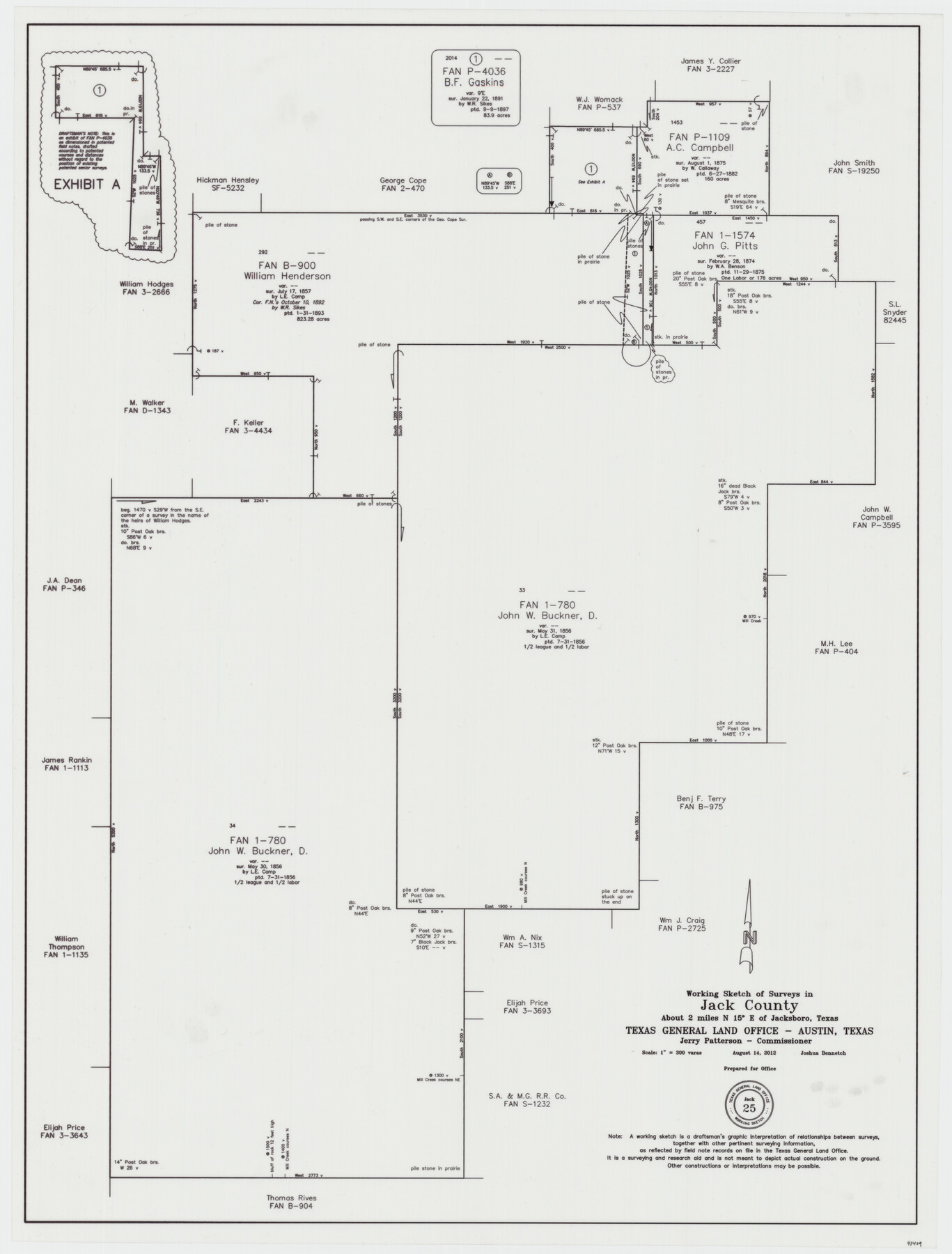
Jack County Working Sketch 25
-
Map/Doc
93409
-
Collection
General Map Collection
-
Object Dates
8/14/2012 (Creation Date)
-
People and Organizations
Joshua Bennetch (Draftsman)
-
Counties
Jack
-
Subjects
Surveying Working Sketch
-
Height x Width
32.7 x 24.9 inches
83.1 x 63.3 cm
-
Scale
1" = 300 varas
Part of: General Map Collection
Trinity River, Levee Improvement Districts, Widths of Floodways

Print $4.00
- Digital $50.00
Trinity River, Levee Improvement Districts, Widths of Floodways
1919
Size 23.5 x 17.6 inches
Map/Doc 65250
Flight Mission No. DQO-3K, Frame 17, Galveston County

Print $20.00
- Digital $50.00
Flight Mission No. DQO-3K, Frame 17, Galveston County
1952
Size 18.9 x 22.5 inches
Map/Doc 85058
Wise County Sketch File 29

Print $20.00
- Digital $50.00
Wise County Sketch File 29
1857
Size 11.1 x 20.7 inches
Map/Doc 76762
Lynn County Boundary File 9a

Print $80.00
- Digital $50.00
Lynn County Boundary File 9a
Size 9.3 x 6.4 inches
Map/Doc 56669
Nolan County Working Sketch Graphic Index

Print $20.00
- Digital $50.00
Nolan County Working Sketch Graphic Index
1935
Size 41.6 x 36.9 inches
Map/Doc 76654
Plan B, Part 3rd Shewing that portion of the boundary between Texas and the United States, included between Logan's Ferry on the River Sabine and the intersection of the 32nd degree of N. Latitude with the western bank of the said river

Print $20.00
- Digital $50.00
Plan B, Part 3rd Shewing that portion of the boundary between Texas and the United States, included between Logan's Ferry on the River Sabine and the intersection of the 32nd degree of N. Latitude with the western bank of the said river
1842
Size 19.4 x 27.2 inches
Map/Doc 65411
Red River County Working Sketch 80

Print $20.00
- Digital $50.00
Red River County Working Sketch 80
1982
Size 24.1 x 29.3 inches
Map/Doc 72063
Knox County Sketch File 27

Print $20.00
- Digital $50.00
Knox County Sketch File 27
1963
Size 20.3 x 19.7 inches
Map/Doc 11964
Bexar County Working Sketch 20

Print $20.00
- Digital $50.00
Bexar County Working Sketch 20
1982
Size 42.4 x 43.6 inches
Map/Doc 67336
Kinney County Rolled Sketch 21

Print $40.00
- Digital $50.00
Kinney County Rolled Sketch 21
1992
Size 39.2 x 57.2 inches
Map/Doc 9358
Zapata County Rolled Sketch 7A

Print $20.00
- Digital $50.00
Zapata County Rolled Sketch 7A
1912
Size 17.9 x 26.6 inches
Map/Doc 8309
[St. L. S-W. Ry. Of Texas Map of Lufkin Branch in Cherokee County Texas]
![64022, [St. L. S-W. Ry. Of Texas Map of Lufkin Branch in Cherokee County Texas], General Map Collection](https://historictexasmaps.com/wmedia_w700/maps/64022.tif.jpg)
Print $40.00
- Digital $50.00
[St. L. S-W. Ry. Of Texas Map of Lufkin Branch in Cherokee County Texas]
1912
Size 23.1 x 122.7 inches
Map/Doc 64022
You may also like
Liberty County Working Sketch 21

Print $20.00
- Digital $50.00
Liberty County Working Sketch 21
1940
Size 20.1 x 15.0 inches
Map/Doc 70480
Mitchell County, Texas

Print $20.00
- Digital $50.00
Mitchell County, Texas
1870
Size 22.7 x 18.0 inches
Map/Doc 741
Flight Mission No. BRE-2P, Frame 16, Nueces County

Print $20.00
- Digital $50.00
Flight Mission No. BRE-2P, Frame 16, Nueces County
1956
Size 18.3 x 22.2 inches
Map/Doc 86725
Reagan County Working Sketch 4

Print $20.00
- Digital $50.00
Reagan County Working Sketch 4
1923
Size 16.8 x 26.3 inches
Map/Doc 71844
Orange County Rolled Sketch 23

Print $20.00
- Digital $50.00
Orange County Rolled Sketch 23
1950
Size 29.0 x 35.3 inches
Map/Doc 7185
Flight Mission No. DCL-6C, Frame 16, Kenedy County

Print $20.00
- Digital $50.00
Flight Mission No. DCL-6C, Frame 16, Kenedy County
1943
Size 18.7 x 22.3 inches
Map/Doc 85873
Maps of Gulf Intracoastal Waterway, Texas - Sabine River to the Rio Grande and connecting waterways including ship channels

Print $20.00
- Digital $50.00
Maps of Gulf Intracoastal Waterway, Texas - Sabine River to the Rio Grande and connecting waterways including ship channels
1966
Size 14.6 x 20.5 inches
Map/Doc 62000
Map of Fisher & Miller's Colony made from the records in the office of the District Surveyor of Bexar comprising also all the recent surveys

Print $20.00
- Digital $50.00
Map of Fisher & Miller's Colony made from the records in the office of the District Surveyor of Bexar comprising also all the recent surveys
1855
Size 22.6 x 36.2 inches
Map/Doc 633
Hopkins County Sketch File 13

Print $4.00
- Digital $50.00
Hopkins County Sketch File 13
1858
Size 12.7 x 8.2 inches
Map/Doc 26709
[Surveys along the Jefferson and Jasper County Boundary]
![92, [Surveys along the Jefferson and Jasper County Boundary], General Map Collection](https://historictexasmaps.com/wmedia_w700/maps/92.tif.jpg)
Print $3.00
- Digital $50.00
[Surveys along the Jefferson and Jasper County Boundary]
1841
Size 11.8 x 16.3 inches
Map/Doc 92
Harris County Rolled Sketch 30

Print $20.00
- Digital $50.00
Harris County Rolled Sketch 30
1889
Size 30.4 x 35.1 inches
Map/Doc 6096
Right of Way and Track Map, the Missouri, Kansas and Texas Ry. of Texas operated by the Missouri, Kansas and Texas Ry. of Texas, San Antonio Division

Print $40.00
- Digital $50.00
Right of Way and Track Map, the Missouri, Kansas and Texas Ry. of Texas operated by the Missouri, Kansas and Texas Ry. of Texas, San Antonio Division
1918
Size 25.6 x 57.8 inches
Map/Doc 64582