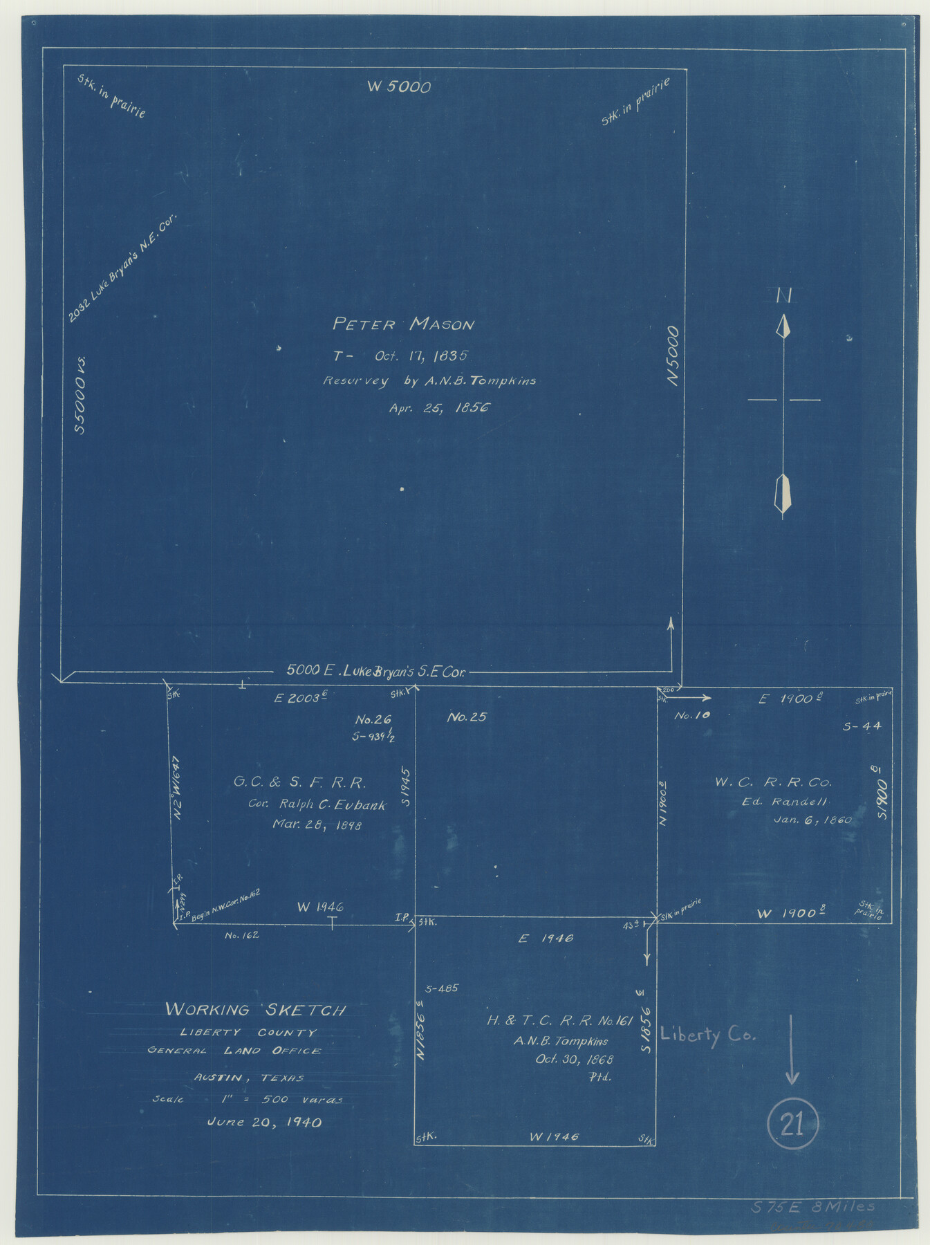
Liberty County Working Sketch 21
-
Map/Doc
70480
-
Collection
General Map Collection
-
Object Dates
6/20/1940 (Creation Date)
-
Counties
Liberty
-
Subjects
Surveying Working Sketch
-
Height x Width
20.1 x 15.0 inches
51.1 x 38.1 cm
-
Scale
1" = 500 varas
Part of: General Map Collection
Flight Mission No. BRA-16M, Frame 73, Jefferson County

Print $20.00
- Digital $50.00
Flight Mission No. BRA-16M, Frame 73, Jefferson County
1953
Size 18.7 x 22.3 inches
Map/Doc 85690
Anderson County Rolled Sketch 10

Print $20.00
- Digital $50.00
Anderson County Rolled Sketch 10
1956
Size 33.4 x 34.6 inches
Map/Doc 8365
Hutchinson County Working Sketch 45

Print $20.00
- Digital $50.00
Hutchinson County Working Sketch 45
1979
Size 20.3 x 17.5 inches
Map/Doc 66405
Val Verde County Working Sketch 69

Print $20.00
- Digital $50.00
Val Verde County Working Sketch 69
1965
Size 35.6 x 37.3 inches
Map/Doc 72204
Foard County Sketch File 32

Print $4.00
- Digital $50.00
Foard County Sketch File 32
1950
Size 14.5 x 9.0 inches
Map/Doc 22864
Nueces County Sketch File 66

Print $18.00
- Digital $50.00
Nueces County Sketch File 66
1981
Size 14.3 x 8.8 inches
Map/Doc 32989
Rusk County Rolled Sketch 10

Print $18.00
- Digital $50.00
Rusk County Rolled Sketch 10
Size 9.7 x 11.3 inches
Map/Doc 48864
Liberty County Working Sketch 58

Print $40.00
- Digital $50.00
Liberty County Working Sketch 58
1968
Size 37.3 x 70.3 inches
Map/Doc 70518
Texas Hill Country Trail Region

Texas Hill Country Trail Region
Size 18.1 x 24.2 inches
Map/Doc 96872
Starr County Working Sketch 9

Print $20.00
- Digital $50.00
Starr County Working Sketch 9
1940
Size 41.5 x 21.4 inches
Map/Doc 63925
Coast Chart No. 210 Aransas Pass and Corpus Christi Bay with the coast to latitude 27° 12' Texas

Print $20.00
- Digital $50.00
Coast Chart No. 210 Aransas Pass and Corpus Christi Bay with the coast to latitude 27° 12' Texas
1887
Size 27.5 x 18.4 inches
Map/Doc 72786
Matagorda Bay and Approaches

Print $20.00
- Digital $50.00
Matagorda Bay and Approaches
1948
Size 35.3 x 45.0 inches
Map/Doc 73380
You may also like
Val Verde County Working Sketch 89

Print $20.00
- Digital $50.00
Val Verde County Working Sketch 89
1974
Size 24.5 x 29.0 inches
Map/Doc 72224
Cherokee County Sketch File 27

Print $4.00
- Digital $50.00
Cherokee County Sketch File 27
1852
Size 8.3 x 8.2 inches
Map/Doc 18171
Flight Mission No. DQN-2K, Frame 114, Calhoun County

Print $20.00
- Digital $50.00
Flight Mission No. DQN-2K, Frame 114, Calhoun County
1953
Size 18.5 x 22.2 inches
Map/Doc 84290

Texas Aranzas-Bay [sic]
![145, Texas Aranzas-Bay [sic], General Map Collection](https://historictexasmaps.com/wmedia_w700/maps/145.tif.jpg)
Print $20.00
- Digital $50.00
Texas Aranzas-Bay [sic]
1832
Size 21.4 x 15.5 inches
Map/Doc 145
Webb County Working Sketch 58

Print $20.00
- Digital $50.00
Webb County Working Sketch 58
1958
Size 37.4 x 37.0 inches
Map/Doc 72424
Map of the southern states, including rail roads, county towns, state capitals, count roads, the southern coast from Delaware to Texas, showing the harbors, inlets, forts and position of blockading ships.

Print $20.00
Map of the southern states, including rail roads, county towns, state capitals, count roads, the southern coast from Delaware to Texas, showing the harbors, inlets, forts and position of blockading ships.
1863
Size 20.1 x 29.9 inches
Map/Doc 93571
Map of Texas comprising the grant of the Texian Emigration and Land-Company

Print $20.00
- Digital $50.00
Map of Texas comprising the grant of the Texian Emigration and Land-Company
1843
Size 9.4 x 10.1 inches
Map/Doc 94049
Lynn County Boundary File 12

Print $60.00
- Digital $50.00
Lynn County Boundary File 12
Size 14.0 x 17.5 inches
Map/Doc 56749
Van Zandt County Working Sketch 10

Print $20.00
- Digital $50.00
Van Zandt County Working Sketch 10
1982
Size 12.4 x 13.1 inches
Map/Doc 72260
[Gulf, Colorado & Santa Fe Railroad Company Block G & M]
![90837, [Gulf, Colorado & Santa Fe Railroad Company Block G & M], Twichell Survey Records](https://historictexasmaps.com/wmedia_w700/maps/90837-2.tif.jpg)
Print $20.00
- Digital $50.00
[Gulf, Colorado & Santa Fe Railroad Company Block G & M]
Size 18.6 x 9.2 inches
Map/Doc 90837
Tom Green County Rolled Sketch 29

Print $20.00
- Digital $50.00
Tom Green County Rolled Sketch 29
Size 17.8 x 23.4 inches
Map/Doc 93646