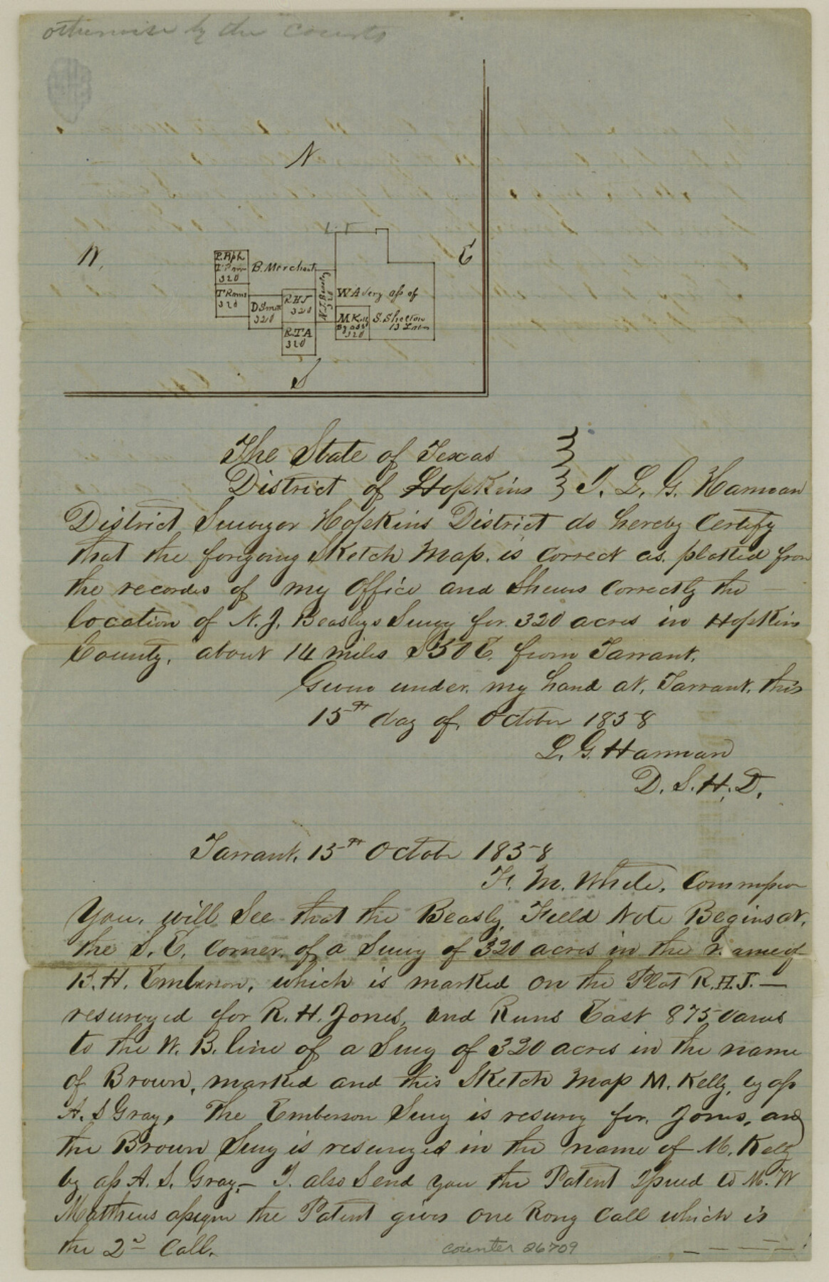
Hopkins County Sketch File 13
[Letter regarding area in southeast of Sulphur Springs]
-
Map/Doc
26709
-
Collection
General Map Collection
-
Object Dates
10/15/1858 (Creation Date)
10/15/1838 (Correspondence Date)
-
People and Organizations
L.G. Harman (Surveyor/Engineer)
-
Counties
Hopkins
-
Subjects
Surveying Sketch File
-
Height x Width
12.7 x 8.2 inches
32.3 x 20.8 cm
-
Medium
paper, manuscript
Part of: General Map Collection
[Letters to and from Maj. W. J. Powell regarding surveys of Texas and Pacific Ry. Lands west of the Pecos. Blks 53-55, Township 1 & 2 map within]
![2249, [Letters to and from Maj. W. J. Powell regarding surveys of Texas and Pacific Ry. Lands west of the Pecos. Blks 53-55, Township 1 & 2 map within], General Map Collection](https://historictexasmaps.com/wmedia_w700/pdf_converted_jpg/qi_pdf_thumbnail_1039.jpg)
Print $124.00
- Digital $50.00
[Letters to and from Maj. W. J. Powell regarding surveys of Texas and Pacific Ry. Lands west of the Pecos. Blks 53-55, Township 1 & 2 map within]
1934
Size 10.2 x 15.4 inches
Map/Doc 2249
Coryell County Sketch File 4

Print $6.00
- Digital $50.00
Coryell County Sketch File 4
1854
Size 12.8 x 8.2 inches
Map/Doc 19342
Briscoe County Sketch File 5

Print $40.00
- Digital $50.00
Briscoe County Sketch File 5
Size 29.8 x 26.5 inches
Map/Doc 10994
Knox County Working Sketch Graphic Index

Print $20.00
- Digital $50.00
Knox County Working Sketch Graphic Index
1923
Size 44.8 x 39.4 inches
Map/Doc 76611
Harris County Boundary File 1

Print $6.00
- Digital $50.00
Harris County Boundary File 1
1963
Size 9.2 x 11.2 inches
Map/Doc 54292
Taylor County Sketch File 23

Print $19.00
- Digital $50.00
Taylor County Sketch File 23
2005
Size 11.0 x 8.5 inches
Map/Doc 87114
Upton County Sketch File 28

Print $5.00
- Digital $50.00
Upton County Sketch File 28
1929
Size 22.8 x 31.8 inches
Map/Doc 12521
Louisiana and Texas Intracoastal Waterway

Print $20.00
- Digital $50.00
Louisiana and Texas Intracoastal Waterway
1929
Size 13.7 x 19.0 inches
Map/Doc 83344
McMullen County Working Sketch 20

Print $20.00
- Digital $50.00
McMullen County Working Sketch 20
1945
Size 34.1 x 29.6 inches
Map/Doc 70721
El Paso County State Real Property Sketch 2

Print $20.00
- Digital $50.00
El Paso County State Real Property Sketch 2
2007
Size 24.4 x 36.2 inches
Map/Doc 88671
Flight Mission No. DQN-3K, Frame 37, Calhoun County

Print $20.00
- Digital $50.00
Flight Mission No. DQN-3K, Frame 37, Calhoun County
1953
Size 16.4 x 16.1 inches
Map/Doc 84350
Sterling County Working Sketch 5

Print $20.00
- Digital $50.00
Sterling County Working Sketch 5
1954
Size 18.9 x 34.9 inches
Map/Doc 63987
You may also like
Smith County Sketch File 12

Print $4.00
- Digital $50.00
Smith County Sketch File 12
1859
Size 8.3 x 12.0 inches
Map/Doc 36769
Andrews County

Print $40.00
- Digital $50.00
Andrews County
1925
Size 42.6 x 57.1 inches
Map/Doc 66703
Parker County Working Sketch 18

Print $20.00
- Digital $50.00
Parker County Working Sketch 18
2000
Map/Doc 71468
Webb County Sketch File 8-1

Print $20.00
- Digital $50.00
Webb County Sketch File 8-1
1929
Size 38.3 x 31.1 inches
Map/Doc 10429
Presidio County Working Sketch 39

Print $20.00
- Digital $50.00
Presidio County Working Sketch 39
1948
Size 44.6 x 43.4 inches
Map/Doc 71716
Flight Mission No. BQR-4K, Frame 71, Brazoria County

Print $20.00
- Digital $50.00
Flight Mission No. BQR-4K, Frame 71, Brazoria County
1952
Size 18.8 x 22.4 inches
Map/Doc 84004
Map of Blocks A, B and C in Parmer County, Texas showing a portion of the C. F. L. & I. Co's. XIT Lands

Print $20.00
- Digital $50.00
Map of Blocks A, B and C in Parmer County, Texas showing a portion of the C. F. L. & I. Co's. XIT Lands
1905
Size 24.2 x 29.4 inches
Map/Doc 91611
Runnels County

Print $40.00
- Digital $50.00
Runnels County
1948
Size 48.8 x 38.8 inches
Map/Doc 73278
Carter Park Addition

Print $20.00
- Digital $50.00
Carter Park Addition
1952
Size 18.3 x 23.2 inches
Map/Doc 92769
Presidio County Working Sketch 57

Print $20.00
- Digital $50.00
Presidio County Working Sketch 57
1955
Size 47.3 x 39.3 inches
Map/Doc 71734
First Addition to Amherst Suburban Farms

Print $20.00
- Digital $50.00
First Addition to Amherst Suburban Farms
Size 26.5 x 20.6 inches
Map/Doc 92430
Aransas Pass to Baffin Bay

Print $20.00
- Digital $50.00
Aransas Pass to Baffin Bay
1976
Size 41.9 x 35.3 inches
Map/Doc 73419