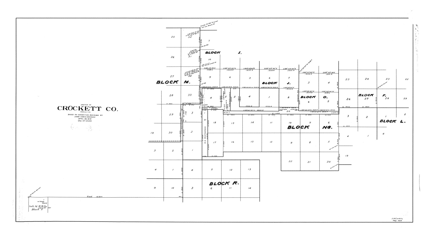
Crockett County Rolled Sketch 30
Sketch in Crockett Co. based on connection described by Judge Chas. E. Davidson, April 30, 1919
-
Map/Doc
8700
-
Collection
General Map Collection
-
Object Dates
1934/5/16 (File Date)
1934 (Creation Date)
-
People and Organizations
J.A. Conklin (Surveyor/Engineer)
-
Counties
Crockett
-
Subjects
Surveying Rolled Sketch
-
Height x Width
24.5 x 43.1 inches
62.2 x 109.5 cm
-
Comments
See SF-12125. Also see Crockett County Sketch File 96 (19964).
Related maps
Crockett County Sketch File 96

Print $4.00
- Digital $50.00
Crockett County Sketch File 96
1934
Size 11.4 x 8.9 inches
Map/Doc 19964
Part of: General Map Collection
Bee County Rolled Sketch 1

Print $20.00
- Digital $50.00
Bee County Rolled Sketch 1
2022
Size 24.4 x 36.0 inches
Map/Doc 97029
South Sulphur River, Charleston Sheet

Print $4.00
- Digital $50.00
South Sulphur River, Charleston Sheet
1924
Size 29.4 x 29.5 inches
Map/Doc 65168
Map showing survey for proposed ship channel from Brownsville to Brazos Santiago Pass

Print $20.00
- Digital $50.00
Map showing survey for proposed ship channel from Brownsville to Brazos Santiago Pass
1912
Size 18.1 x 28.7 inches
Map/Doc 72902
Uvalde County Working Sketch 12

Print $20.00
- Digital $50.00
Uvalde County Working Sketch 12
1943
Size 28.5 x 27.4 inches
Map/Doc 72082
Crane County Working Sketch 18

Print $20.00
- Digital $50.00
Crane County Working Sketch 18
1959
Size 37.9 x 18.8 inches
Map/Doc 68295
Bexar County Sketch File 34

Print $23.00
- Digital $50.00
Bexar County Sketch File 34
1872
Size 12.2 x 12.5 inches
Map/Doc 14498
Matagorda County Sketch File 46

Print $107.00
- Digital $50.00
Matagorda County Sketch File 46
1985
Size 11.2 x 8.5 inches
Map/Doc 30932
Lee County Working Sketch 19

Print $20.00
- Digital $50.00
Lee County Working Sketch 19
1991
Size 33.1 x 20.1 inches
Map/Doc 70398
Nueces River, Bluntzer Sheet

Print $20.00
- Digital $50.00
Nueces River, Bluntzer Sheet
1927
Size 35.3 x 42.9 inches
Map/Doc 65088
Presidio County Working Sketch 130

Print $20.00
- Digital $50.00
Presidio County Working Sketch 130
1989
Size 22.1 x 43.1 inches
Map/Doc 71808
Medina County Working Sketch 7

Print $20.00
- Digital $50.00
Medina County Working Sketch 7
1952
Size 26.3 x 28.5 inches
Map/Doc 70922
Uvalde County Working Sketch 38

Print $20.00
- Digital $50.00
Uvalde County Working Sketch 38
1970
Size 33.3 x 30.8 inches
Map/Doc 72108
You may also like
Brewster County Rolled Sketch 114

Print $20.00
- Digital $50.00
Brewster County Rolled Sketch 114
1964
Size 11.8 x 18.5 inches
Map/Doc 5264
Ector County Working Sketch 10
Print $20.00
- Digital $50.00
Ector County Working Sketch 10
1953
Size 25.4 x 39.0 inches
Map/Doc 68853
Sutton County Working Sketch 5

Print $20.00
- Digital $50.00
Sutton County Working Sketch 5
1969
Size 25.4 x 33.4 inches
Map/Doc 62348
[T. & P. Blocks 35 and 36, Township 4 North; Block I, Township 4 North]
![91297, [T. & P. Blocks 35 and 36, Township 4 North; Block I, Township 4 North], Twichell Survey Records](https://historictexasmaps.com/wmedia_w700/maps/91297-1.tif.jpg)
Print $20.00
- Digital $50.00
[T. & P. Blocks 35 and 36, Township 4 North; Block I, Township 4 North]
Size 19.3 x 22.2 inches
Map/Doc 91297
Crockett County Rolled Sketch 44

Print $20.00
- Digital $50.00
Crockett County Rolled Sketch 44
Size 44.5 x 36.8 inches
Map/Doc 76170
Oldham County Working Sketch 6

Print $40.00
- Digital $50.00
Oldham County Working Sketch 6
1981
Size 32.4 x 50.4 inches
Map/Doc 71328
Shores of Nueces Bay, Texas

Print $40.00
- Digital $50.00
Shores of Nueces Bay, Texas
1882
Size 33.0 x 54.3 inches
Map/Doc 73464

[Terry County Highways]
![92905, [Terry County Highways], Twichell Survey Records](https://historictexasmaps.com/wmedia_w700/maps/92905-1.tif.jpg)
Print $20.00
- Digital $50.00
[Terry County Highways]
Size 17.0 x 16.8 inches
Map/Doc 92905
Culberson County Sketch File 5

Print $4.00
- Digital $50.00
Culberson County Sketch File 5
Size 9.4 x 8.2 inches
Map/Doc 20136
Sutton County Sketch File 61

Print $14.00
- Digital $50.00
Sutton County Sketch File 61
1986
Size 11.2 x 8.9 inches
Map/Doc 37557
Atascosa County

Print $20.00
- Digital $50.00
Atascosa County
1873
Size 22.2 x 23.1 inches
Map/Doc 3249