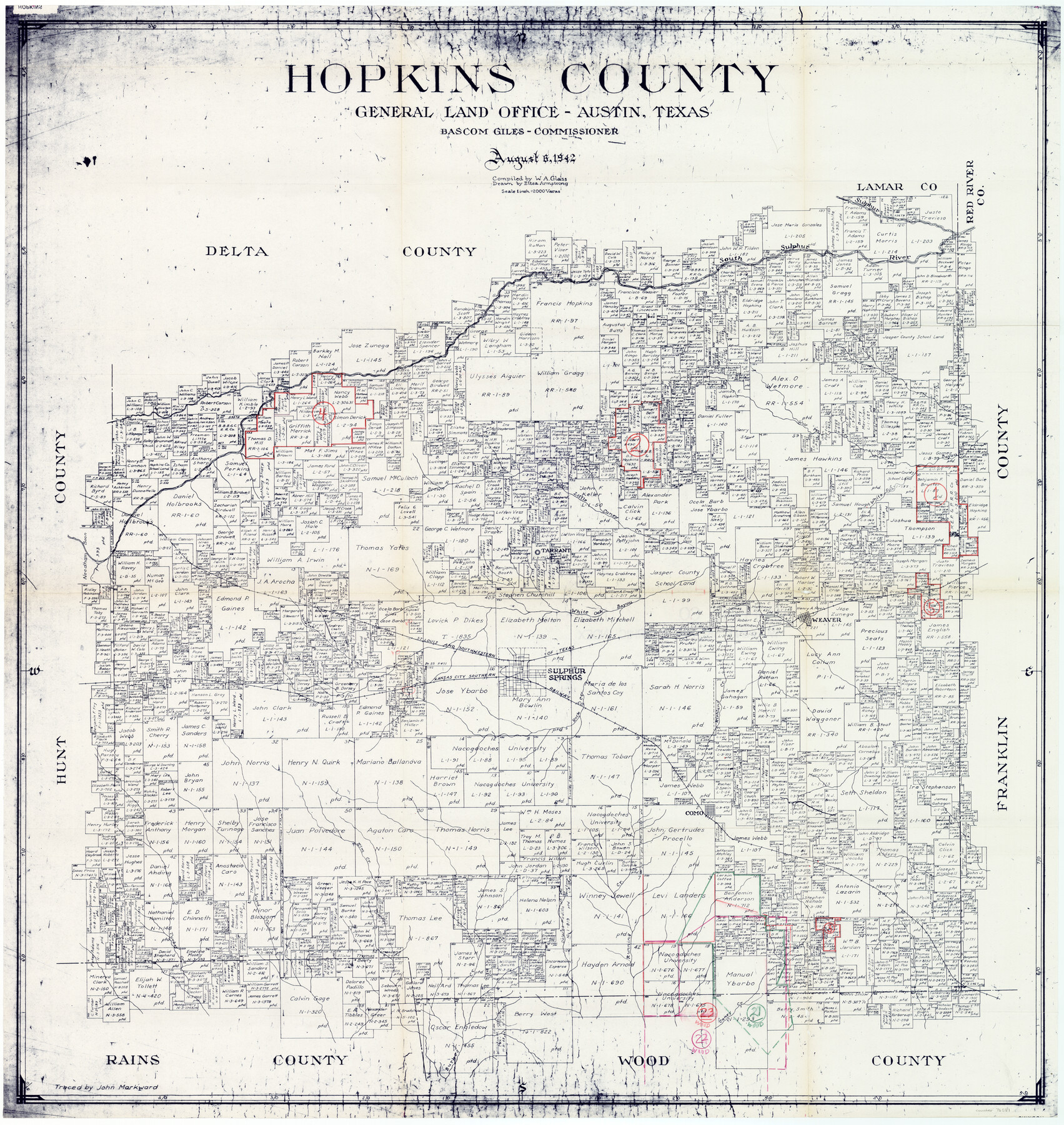
Hopkins County Working Sketch Graphic Index
-
Map/Doc
76581
-
Collection
General Map Collection
-
Object Dates
8/6/1942 (Creation Date)
-
People and Organizations
W.A. Glass (Compiler)
Eltea Armstrong (Draftsman)
-
Counties
Hopkins
-
Subjects
County Surveying Working Sketch
-
Height x Width
40.6 x 38.7 inches
103.1 x 98.3 cm
-
Scale
1" = 2000 varas
Part of: General Map Collection
Gulf Intracoastal Waterway - Aransas Bay to Corpus Christi Bay - Modified Route Main Channel

Print $20.00
- Digital $50.00
Gulf Intracoastal Waterway - Aransas Bay to Corpus Christi Bay - Modified Route Main Channel
1960
Size 31.3 x 42.7 inches
Map/Doc 61902
Official Map of the City of Bryan from Actual Survey [West Part]
![76864, Official Map of the City of Bryan from Actual Survey [West Part], General Map Collection](https://historictexasmaps.com/wmedia_w700/maps/76864.tif.jpg)
Print $40.00
- Digital $50.00
Official Map of the City of Bryan from Actual Survey [West Part]
1898
Size 52.5 x 27.4 inches
Map/Doc 76864
Lee County Working Sketch 20

Print $20.00
- Digital $50.00
Lee County Working Sketch 20
1992
Size 25.3 x 35.4 inches
Map/Doc 70399
Clay County Sketch File 3

Print $2.00
- Digital $50.00
Clay County Sketch File 3
Size 8.7 x 7.7 inches
Map/Doc 18391
Cameron County Rolled Sketch 28A

Print $20.00
- Digital $50.00
Cameron County Rolled Sketch 28A
1986
Size 36.0 x 47.6 inches
Map/Doc 8576
Duval County Sketch File 76

Print $20.00
- Digital $50.00
Duval County Sketch File 76
1959
Size 15.1 x 27.3 inches
Map/Doc 11410
Cooke County Boundary File 20

Print $88.00
- Digital $50.00
Cooke County Boundary File 20
Size 3.2 x 8.6 inches
Map/Doc 51873
Location of the Southern Kansas Railway of Texas, Gray County, Texas

Print $40.00
- Digital $50.00
Location of the Southern Kansas Railway of Texas, Gray County, Texas
1887
Size 19.9 x 75.3 inches
Map/Doc 64036
Coke County Sketch File 36

Print $24.00
- Digital $50.00
Coke County Sketch File 36
1918
Size 14.1 x 8.5 inches
Map/Doc 18652
Coke County Working Sketch 26

Print $20.00
- Digital $50.00
Coke County Working Sketch 26
1961
Size 29.1 x 31.2 inches
Map/Doc 68063
Briscoe County Sketch File D-1

Print $50.00
- Digital $50.00
Briscoe County Sketch File D-1
1901
Size 9.9 x 6.3 inches
Map/Doc 16406
Grayson County Working Sketch 6

Print $20.00
- Digital $50.00
Grayson County Working Sketch 6
1940
Size 28.6 x 40.5 inches
Map/Doc 63245
You may also like
Map of King County

Print $20.00
- Digital $50.00
Map of King County
1903
Size 45.4 x 42.9 inches
Map/Doc 66892
Pecos County Working Sketch 106

Print $40.00
- Digital $50.00
Pecos County Working Sketch 106
1971
Size 64.9 x 38.1 inches
Map/Doc 71579
Galveston Bay Entrance - Galveston and Texas City Harbors

Print $40.00
- Digital $50.00
Galveston Bay Entrance - Galveston and Texas City Harbors
1975
Size 37.4 x 53.5 inches
Map/Doc 69864
Hockley County Sketch File 4

Print $6.00
- Digital $50.00
Hockley County Sketch File 4
Size 9.1 x 11.2 inches
Map/Doc 26536
Reagan County Rolled Sketch R

Print $20.00
- Digital $50.00
Reagan County Rolled Sketch R
Size 33.0 x 31.0 inches
Map/Doc 10734
Schleicher County Sketch File 20

Print $20.00
- Digital $50.00
Schleicher County Sketch File 20
1936
Size 16.8 x 17.4 inches
Map/Doc 12301
Bosque County Sketch File 2

Print $4.00
- Digital $50.00
Bosque County Sketch File 2
1847
Size 7.8 x 12.4 inches
Map/Doc 14740
Atascosa County Sketch File 15

Print $6.00
- Digital $50.00
Atascosa County Sketch File 15
1879
Size 7.1 x 13.5 inches
Map/Doc 13775
Boundary Between the United States & Mexico Agreed upon by the Joint Commission under the Treaty of Guadalupe Hidalgo

Print $4.00
- Digital $50.00
Boundary Between the United States & Mexico Agreed upon by the Joint Commission under the Treaty of Guadalupe Hidalgo
1853
Size 18.2 x 26.8 inches
Map/Doc 72882
Flight Mission No. BRA-3M, Frame 129, Jefferson County

Print $20.00
- Digital $50.00
Flight Mission No. BRA-3M, Frame 129, Jefferson County
1953
Size 18.5 x 22.3 inches
Map/Doc 85403
Montgomery County Rolled Sketch 49

Print $20.00
- Digital $50.00
Montgomery County Rolled Sketch 49
2015
Size 36.1 x 23.9 inches
Map/Doc 95186
Burnet County

Print $20.00
- Digital $50.00
Burnet County
1881
Size 16.0 x 16.2 inches
Map/Doc 75785