La Salle County Rolled Sketch 21
[Map and correspondence relating to Cause No. 3376, La Salle County District Court, SF-14828, Alderman vs. Alderman]
-
Map/Doc
46461
-
Collection
General Map Collection
-
Object Dates
1956/1/11 (File Date)
1955 (Creation Date)
-
Counties
La Salle
-
Subjects
Surveying Rolled Sketch
-
Height x Width
10.0 x 15.1 inches
25.4 x 38.4 cm
-
Medium
multi-page, multi-format
-
Comments
See SF-14828.
Part of: General Map Collection
Hockley County Working Sketch 3

Print $20.00
- Digital $50.00
Hockley County Working Sketch 3
1962
Size 35.4 x 22.0 inches
Map/Doc 66193
Flight Mission No. DQN-2K, Frame 135, Calhoun County

Print $20.00
- Digital $50.00
Flight Mission No. DQN-2K, Frame 135, Calhoun County
1953
Size 19.0 x 22.5 inches
Map/Doc 84304
Callahan County

Print $20.00
- Digital $50.00
Callahan County
1918
Size 45.3 x 41.0 inches
Map/Doc 66743
Harris County NRC Article 33.136 Sketch 17

Print $26.00
- Digital $50.00
Harris County NRC Article 33.136 Sketch 17
2011
Size 22.0 x 17.0 inches
Map/Doc 94758
Flight Mission No. DQN-1K, Frame 42, Calhoun County

Print $20.00
- Digital $50.00
Flight Mission No. DQN-1K, Frame 42, Calhoun County
1953
Size 18.5 x 18.7 inches
Map/Doc 84142
Map of the Harlem State Farm and the Central State Farm, Fort Bend County, Texas

Print $20.00
- Digital $50.00
Map of the Harlem State Farm and the Central State Farm, Fort Bend County, Texas
Size 35.7 x 32.1 inches
Map/Doc 62995
Montague County Working Sketch 32

Print $20.00
- Digital $50.00
Montague County Working Sketch 32
1975
Size 26.0 x 26.1 inches
Map/Doc 71098
Menard County Sketch File 7

Print $4.00
- Digital $50.00
Menard County Sketch File 7
Size 5.8 x 12.0 inches
Map/Doc 31492
Flight Mission No. CGI-3N, Frame 160, Cameron County

Print $20.00
- Digital $50.00
Flight Mission No. CGI-3N, Frame 160, Cameron County
1954
Size 18.5 x 22.3 inches
Map/Doc 84624
Flight Mission No. DCL-6C, Frame 128, Kenedy County

Print $20.00
- Digital $50.00
Flight Mission No. DCL-6C, Frame 128, Kenedy County
1943
Size 18.6 x 22.3 inches
Map/Doc 85958
[Letter regarding surveys in Coryell County]
![69754, [Letter regarding surveys in Coryell County], General Map Collection](https://historictexasmaps.com/wmedia_w700/maps/69754.tif.jpg)
Print $2.00
- Digital $50.00
[Letter regarding surveys in Coryell County]
1846
Size 7.7 x 6.4 inches
Map/Doc 69754
Map of the City of Corsicana (Navarro County) Texas

Print $40.00
- Digital $50.00
Map of the City of Corsicana (Navarro County) Texas
1963
Size 40.1 x 91.8 inches
Map/Doc 93674
You may also like
Colton's New Map of the State of Texas, the Indian Territory and adjoining portions of New Mexico, Louisiana and Arkansas

Print $2.00
- Digital $50.00
Colton's New Map of the State of Texas, the Indian Territory and adjoining portions of New Mexico, Louisiana and Arkansas
1882
Size 8.5 x 5.0 inches
Map/Doc 93921
Flight Mission No. CLL-3N, Frame 20, Willacy County

Print $20.00
- Digital $50.00
Flight Mission No. CLL-3N, Frame 20, Willacy County
1954
Size 18.5 x 22.1 inches
Map/Doc 87086
Asher and Adams' Texas - Western Portion

Print $20.00
- Digital $50.00
Asher and Adams' Texas - Western Portion
1874
Size 24.6 x 18.1 inches
Map/Doc 93787
Bandera County Sketch File 35

Print $2.00
- Digital $50.00
Bandera County Sketch File 35
Size 11.2 x 8.7 inches
Map/Doc 14033
Mills County Boundary File 6

Print $2.00
- Digital $50.00
Mills County Boundary File 6
Size 11.0 x 8.6 inches
Map/Doc 57311
Trinity County Sketch File 32

Print $20.00
- Digital $50.00
Trinity County Sketch File 32
1894
Size 22.4 x 18.3 inches
Map/Doc 12490
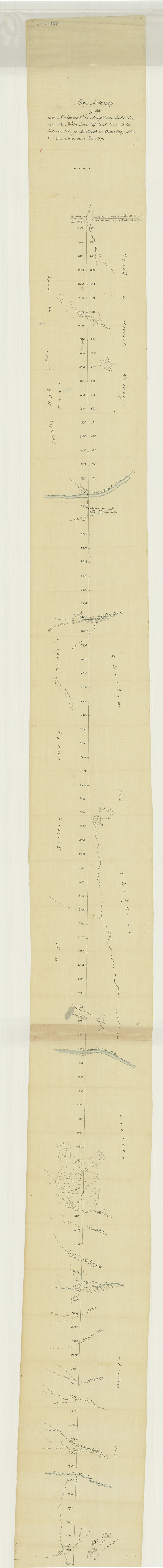
Map of survey of the 100th Meridian west longitude, extending from the north bank of Red River to the intersection of the Northern Boundary of the Creek or Seminole Country
Print $40.00
- Digital $50.00
Map of survey of the 100th Meridian west longitude, extending from the north bank of Red River to the intersection of the Northern Boundary of the Creek or Seminole Country
Size 113.1 x 11.7 inches
Map/Doc 73565
Presidio County Sketch File 89

Print $10.00
- Digital $50.00
Presidio County Sketch File 89
1953
Size 14.3 x 8.9 inches
Map/Doc 34756
Hopkins County Sketch File 10a

Print $4.00
- Digital $50.00
Hopkins County Sketch File 10a
1856
Size 12.2 x 7.8 inches
Map/Doc 26702
Duval County Rolled Sketch Pressly No. 2A

Print $20.00
- Digital $50.00
Duval County Rolled Sketch Pressly No. 2A
1935
Size 22.3 x 34.4 inches
Map/Doc 5771
Hamilton County Working Sketch 13

Print $40.00
- Digital $50.00
Hamilton County Working Sketch 13
1949
Size 43.5 x 57.0 inches
Map/Doc 63351
Upton County Working Sketch 19

Print $40.00
- Digital $50.00
Upton County Working Sketch 19
1949
Size 51.7 x 43.3 inches
Map/Doc 69515