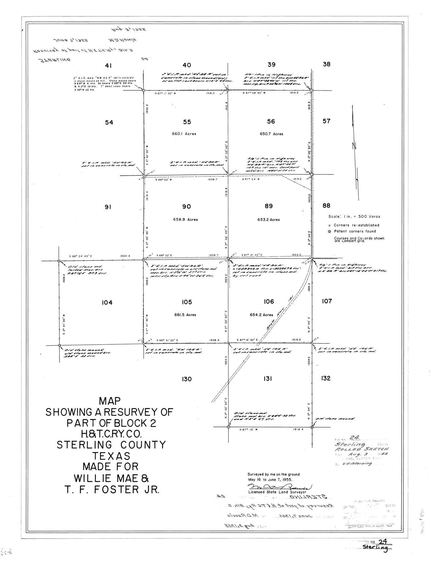
Sterling County Rolled Sketch 24
Map showing a resurvey of part of Block 2, H. & T. C. Ry. Co., Sterling County, Texas made for Willie Mae & T.F. Foster, Jr.
-
Map/Doc
7850
-
Collection
General Map Collection
-
Object Dates
1955/6/7 (Survey Date)
1955/8/3 (File Date)
-
People and Organizations
M.D. Rawls (Surveyor/Engineer)
-
Counties
Sterling
-
Subjects
Surveying Rolled Sketch
-
Height x Width
25.8 x 19.6 inches
65.5 x 49.8 cm
-
Medium
mylar, print
-
Scale
1" = 500 varas
Part of: General Map Collection
Limestone County Sketch File 10

Print $4.00
- Digital $50.00
Limestone County Sketch File 10
Size 8.4 x 9.4 inches
Map/Doc 30171
Bell County Working Sketch 19

Print $40.00
- Digital $50.00
Bell County Working Sketch 19
1994
Size 48.3 x 38.4 inches
Map/Doc 67359

Duval County Sketch File 43

Print $20.00
- Digital $50.00
Duval County Sketch File 43
Size 22.9 x 21.1 inches
Map/Doc 11398
Dimmit County Working Sketch 22

Print $20.00
- Digital $50.00
Dimmit County Working Sketch 22
1951
Size 37.3 x 38.7 inches
Map/Doc 68683
Refugio County Sketch File 17a

Print $2.00
- Digital $50.00
Refugio County Sketch File 17a
1916
Size 11.4 x 9.0 inches
Map/Doc 35275
Controlled Mosaic by Jack Amman Photogrammetric Engineers, Inc - Sheet 29

Print $20.00
- Digital $50.00
Controlled Mosaic by Jack Amman Photogrammetric Engineers, Inc - Sheet 29
1954
Size 20.0 x 24.0 inches
Map/Doc 83482
Index for Texas Railroad ROW & track maps available on microfilm at THD & Archives and Records

Print $2.00
- Digital $50.00
Index for Texas Railroad ROW & track maps available on microfilm at THD & Archives and Records
1977
Size 11.2 x 8.8 inches
Map/Doc 60758
Reagan County Sketch File 1

Print $20.00
- Digital $50.00
Reagan County Sketch File 1
1914
Size 24.3 x 30.3 inches
Map/Doc 12210
Leon County Rolled Sketch 6

Print $20.00
- Digital $50.00
Leon County Rolled Sketch 6
1951
Size 31.6 x 37.6 inches
Map/Doc 6597
Flight Mission No. DCL-5C, Frame 69, Kenedy County

Print $20.00
- Digital $50.00
Flight Mission No. DCL-5C, Frame 69, Kenedy County
1943
Size 18.5 x 22.3 inches
Map/Doc 85852
Flight Mission No. CRC-4R, Frame 64, Chambers County

Print $20.00
- Digital $50.00
Flight Mission No. CRC-4R, Frame 64, Chambers County
1956
Size 18.7 x 22.3 inches
Map/Doc 84868
You may also like

Eastland County Working Sketch 24

Print $20.00
- Digital $50.00
Eastland County Working Sketch 24
1922
Size 36.1 x 27.1 inches
Map/Doc 68805
Wharton County Sketch File 22

Print $20.00
- Digital $50.00
Wharton County Sketch File 22
1911
Size 20.1 x 15.4 inches
Map/Doc 12666
General Highway Map, Dallas County, Rockwall County, Texas

Print $20.00
General Highway Map, Dallas County, Rockwall County, Texas
1936
Size 18.7 x 25.2 inches
Map/Doc 79066
Preliminary Chart of the Entrance to Brazos River, Texas

Print $20.00
Preliminary Chart of the Entrance to Brazos River, Texas
1858
Size 17.9 x 21.3 inches
Map/Doc 76249
Red River County Sketch File 12

Print $40.00
- Digital $50.00
Red River County Sketch File 12
Size 12.5 x 21.5 inches
Map/Doc 35129
Reagan County Rolled Sketch 17

Print $20.00
- Digital $50.00
Reagan County Rolled Sketch 17
Size 34.8 x 32.9 inches
Map/Doc 9812
La Salle County Working Sketch 35

Print $20.00
- Digital $50.00
La Salle County Working Sketch 35
1958
Size 31.4 x 16.8 inches
Map/Doc 70336
J. De Cordova's Map of the State of Texas Compiled from the records of the General Land Office of the State

Print $20.00
J. De Cordova's Map of the State of Texas Compiled from the records of the General Land Office of the State
1849
Size 35.7 x 33.6 inches
Map/Doc 93964
Republic Counties. January 1, 1840

Print $20.00
Republic Counties. January 1, 1840
2020
Size 24.5 x 21.7 inches
Map/Doc 96313
Ellis County Sketch File 7

Print $40.00
- Digital $50.00
Ellis County Sketch File 7
1859
Size 12.2 x 15.6 inches
Map/Doc 21839
Galveston County NRC Article 33.136 Sketch 29

Print $21.00
- Digital $50.00
Galveston County NRC Article 33.136 Sketch 29
2005
Size 22.4 x 31.9 inches
Map/Doc 83282