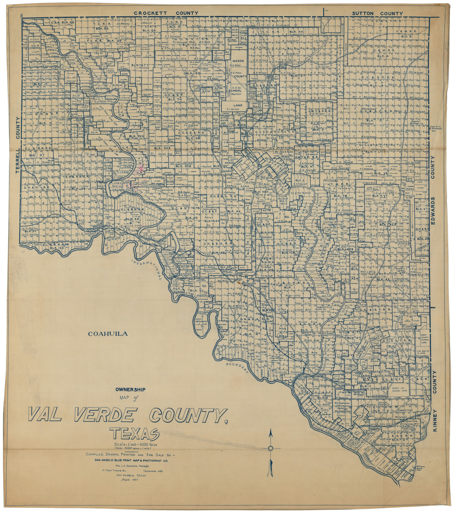
Ownership Map of Val Verde County
-
Map/Doc
92847
-
Collection
Twichell Survey Records
-
Object Dates
8/1927 (Creation Date)
-
People and Organizations
San Angelo Blueprint Map & Photoprint Co. (Draftsman)
San Angelo Blue Print Map & Photoprint Co. (Compiler)
-
Counties
Val Verde
-
Subjects
County
-
Height x Width
32.7 x 36.9 inches
83.1 x 93.7 cm
Part of: Twichell Survey Records
Lands of the Eastern Mediterranean

Lands of the Eastern Mediterranean
1959
Size 25.5 x 19.5 inches
Map/Doc 92383
Revised Plat, Section J, Tech Memorial Park, Inc., Infants Garden

Print $20.00
- Digital $50.00
Revised Plat, Section J, Tech Memorial Park, Inc., Infants Garden
1961
Size 29.1 x 33.7 inches
Map/Doc 92786
[Oil and Gas Fields in West Texas]
![89884, [Oil and Gas Fields in West Texas], Twichell Survey Records](https://historictexasmaps.com/wmedia_w700/maps/89884-1.tif.jpg)
Print $40.00
- Digital $50.00
[Oil and Gas Fields in West Texas]
Size 38.5 x 59.2 inches
Map/Doc 89884
[Land on East Side of Creek, Exhibit G]
![91372, [Land on East Side of Creek, Exhibit G], Twichell Survey Records](https://historictexasmaps.com/wmedia_w700/maps/91372-1.tif.jpg)
Print $20.00
- Digital $50.00
[Land on East Side of Creek, Exhibit G]
Size 19.4 x 29.6 inches
Map/Doc 91372
[Sections 61-65, I. & G. N. Block 1 and part of Block 194]
![91678, [Sections 61-65, I. & G. N. Block 1 and part of Block 194], Twichell Survey Records](https://historictexasmaps.com/wmedia_w700/maps/91678-1.tif.jpg)
Print $20.00
- Digital $50.00
[Sections 61-65, I. & G. N. Block 1 and part of Block 194]
Size 24.9 x 17.3 inches
Map/Doc 91678
Eubank Farm N/2 of NE/4 Section 3, Block D3

Print $20.00
- Digital $50.00
Eubank Farm N/2 of NE/4 Section 3, Block D3
Size 20.9 x 14.0 inches
Map/Doc 92336
[Washington County RR. Co. Block 1 and Cherokee Iron Furnace Co. Block 1]
![92065, [Washington County RR. Co. Block 1 and Cherokee Iron Furnace Co. Block 1], Twichell Survey Records](https://historictexasmaps.com/wmedia_w700/maps/92065-1.tif.jpg)
Print $20.00
- Digital $50.00
[Washington County RR. Co. Block 1 and Cherokee Iron Furnace Co. Block 1]
1911
Size 22.4 x 25.4 inches
Map/Doc 92065
[Part of Connected map of Stephen F. Austin's Colony on file at the GLO]
![90208, [Part of Connected map of Stephen F. Austin's Colony on file at the GLO], Twichell Survey Records](https://historictexasmaps.com/wmedia_w700/maps/90208-1.tif.jpg)
Print $20.00
- Digital $50.00
[Part of Connected map of Stephen F. Austin's Colony on file at the GLO]
1923
Size 18.8 x 18.2 inches
Map/Doc 90208
Sketch Showing Section 3, Block JW, Subdivided to Show Quantity East of Texas Sections

Print $40.00
- Digital $50.00
Sketch Showing Section 3, Block JW, Subdivided to Show Quantity East of Texas Sections
Size 5.8 x 49.9 inches
Map/Doc 91303
[Block D3, Block A, Block O]
![92750, [Block D3, Block A, Block O], Twichell Survey Records](https://historictexasmaps.com/wmedia_w700/maps/92750-1.tif.jpg)
Print $20.00
- Digital $50.00
[Block D3, Block A, Block O]
Size 25.2 x 13.1 inches
Map/Doc 92750
Working Sketch Carson County

Print $3.00
- Digital $50.00
Working Sketch Carson County
1907
Size 10.6 x 17.1 inches
Map/Doc 90223
[Sketch Between Hemphill County and Oklahoma]
![89664, [Sketch Between Hemphill County and Oklahoma], Twichell Survey Records](https://historictexasmaps.com/wmedia_w700/maps/89664.tif.jpg)
Print $40.00
- Digital $50.00
[Sketch Between Hemphill County and Oklahoma]
Size 8.1 x 62.5 inches
Map/Doc 89664
You may also like
Panola County Working Sketch 27

Print $20.00
- Digital $50.00
Panola County Working Sketch 27
1956
Map/Doc 71436

Bandera County

Print $40.00
- Digital $50.00
Bandera County
1904
Size 30.7 x 61.0 inches
Map/Doc 3274
Maverick County Working Sketch 14

Print $20.00
- Digital $50.00
Maverick County Working Sketch 14
1970
Size 41.2 x 42.6 inches
Map/Doc 70906
Chambers County Rolled Sketch 23

Print $40.00
- Digital $50.00
Chambers County Rolled Sketch 23
1940
Size 36.5 x 49.2 inches
Map/Doc 8591
Liberty County Sketch File 40

Print $3.00
- Digital $50.00
Liberty County Sketch File 40
Size 9.8 x 17.3 inches
Map/Doc 29996
Railroad Track Map, H&TCRRCo., Falls County, Texas

Print $4.00
- Digital $50.00
Railroad Track Map, H&TCRRCo., Falls County, Texas
1918
Size 11.7 x 18.5 inches
Map/Doc 62861
Wise County Rolled Sketch 3

Print $20.00
- Digital $50.00
Wise County Rolled Sketch 3
Size 36.4 x 45.0 inches
Map/Doc 10156
Pecos County Working Sketch 68

Print $20.00
- Digital $50.00
Pecos County Working Sketch 68
1955
Size 41.4 x 24.0 inches
Map/Doc 71540
Oldham County

Print $40.00
- Digital $50.00
Oldham County
1925
Size 41.5 x 53.2 inches
Map/Doc 95604
Concho County Working Sketch 6
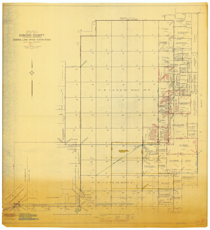
Print $20.00
- Digital $50.00
Concho County Working Sketch 6
1948
Size 47.3 x 43.2 inches
Map/Doc 68188
DeWitt County Working Sketch 13

Print $20.00
- Digital $50.00
DeWitt County Working Sketch 13
1986
Size 37.6 x 40.9 inches
Map/Doc 68603