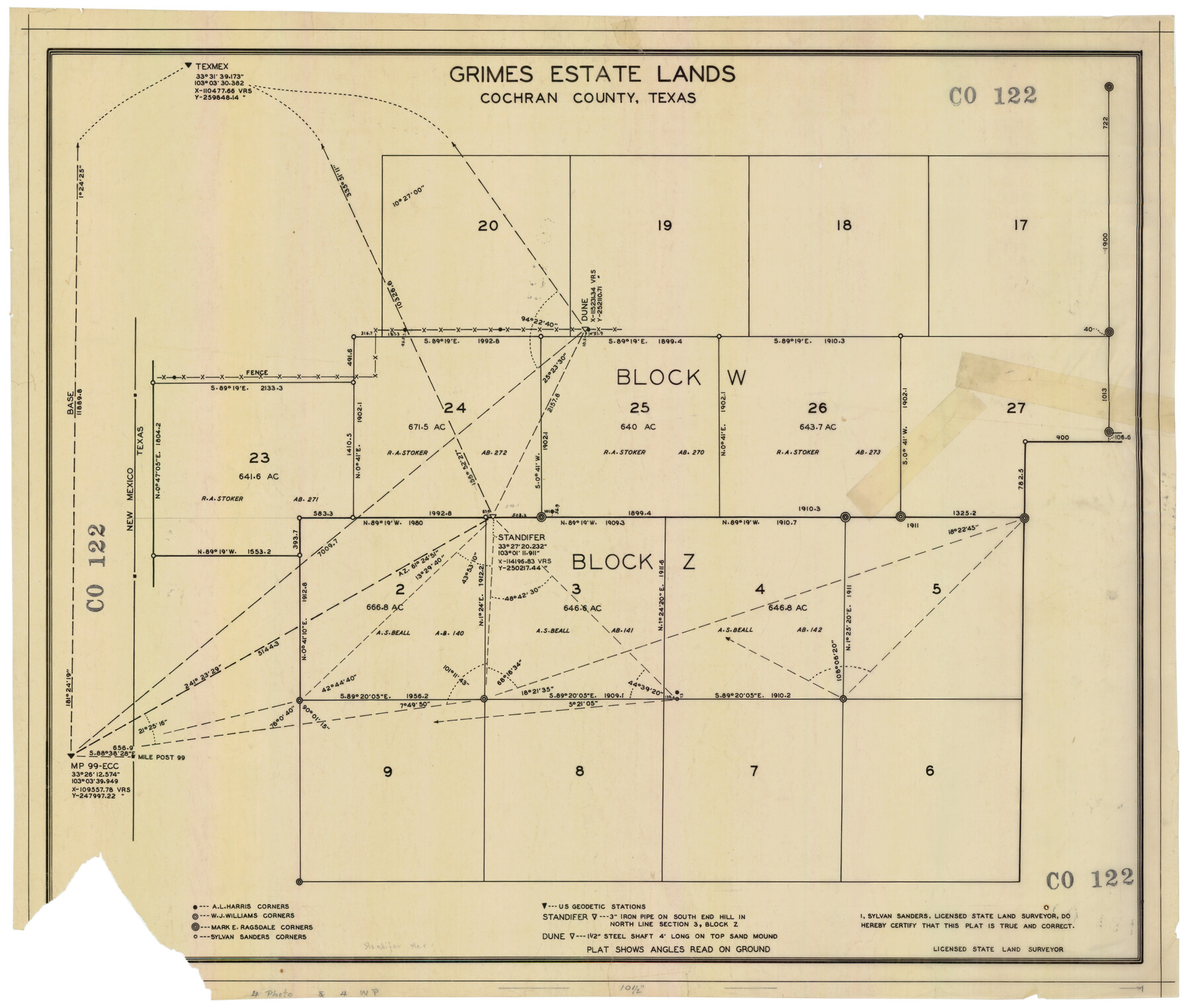
Grimes Estate Lands, Cochran County, Texas
CO122
-
Map/Doc
92520
-
Collection
Twichell Survey Records
-
People and Organizations
Sylvan Sanders (Surveyor/Engineer)
-
Counties
Cochran
-
Height x Width
25.6 x 21.6 inches
65.0 x 54.9 cm
Part of: Twichell Survey Records
Burnham Townsite at Justiceburg

Print $20.00
- Digital $50.00
Burnham Townsite at Justiceburg
Size 36.6 x 29.0 inches
Map/Doc 92694
Renderbrook Ranch

Print $20.00
- Digital $50.00
Renderbrook Ranch
1932
Size 16.9 x 13.5 inches
Map/Doc 92279
Sketch Showing Original Corners Affecting Block I and Adjacent Surveys from Actual Connections by W. D. Twichell

Print $20.00
- Digital $50.00
Sketch Showing Original Corners Affecting Block I and Adjacent Surveys from Actual Connections by W. D. Twichell
Size 23.4 x 24.4 inches
Map/Doc 90162

[Leagues 247, 320, and 321]
![91291, [Leagues 247, 320, and 321], Twichell Survey Records](https://historictexasmaps.com/wmedia_w700/maps/91291-1.tif.jpg)
Print $2.00
- Digital $50.00
[Leagues 247, 320, and 321]
Size 8.2 x 15.1 inches
Map/Doc 91291
Washburn situated in Armstrong County, Texas on surveys 62, 63, 98 & 99, Block B4

Print $20.00
- Digital $50.00
Washburn situated in Armstrong County, Texas on surveys 62, 63, 98 & 99, Block B4
Size 44.2 x 31.4 inches
Map/Doc 90261
Map of Public Roads in Terry County, Texas

Print $20.00
- Digital $50.00
Map of Public Roads in Terry County, Texas
Size 34.0 x 36.1 inches
Map/Doc 91941
W. L. Ellwood's Subdivision of Parts of Leagues 9 and 10, Donley County School Land, 7 Wilbarger County School Land and Parts of Section 50, 61, and 74, Block 20 Hockley County, Texas

Print $20.00
- Digital $50.00
W. L. Ellwood's Subdivision of Parts of Leagues 9 and 10, Donley County School Land, 7 Wilbarger County School Land and Parts of Section 50, 61, and 74, Block 20 Hockley County, Texas
1923
Size 20.2 x 19.8 inches
Map/Doc 92249
[Northwest Garza Co., E. J. Powell surveys and vicinity]
![90852, [Northwest Garza Co., E. J. Powell surveys and vicinity], Twichell Survey Records](https://historictexasmaps.com/wmedia_w700/maps/90852-2.tif.jpg)
Print $2.00
- Digital $50.00
[Northwest Garza Co., E. J. Powell surveys and vicinity]
Size 8.9 x 14.2 inches
Map/Doc 90852
[Sketch of Railroad Switchyard stretching from Ross to Monroe Streets, Amarillo, Texas]
![91830, [Sketch of Railroad Switchyard stretching from Ross to Monroe Streets, Amarillo, Texas], Twichell Survey Records](https://historictexasmaps.com/wmedia_w700/maps/91830-1.tif.jpg)
Print $20.00
- Digital $50.00
[Sketch of Railroad Switchyard stretching from Ross to Monroe Streets, Amarillo, Texas]
Size 10.0 x 36.1 inches
Map/Doc 91830
[G. C. & S. 35, Part of H. & T. C. 49, Capitol Leagues 217, 218, 223, 224, 225]
![90687, [G. C. & S. 35, Part of H. & T. C. 49, Capitol Leagues 217, 218, 223, 224, 225], Twichell Survey Records](https://historictexasmaps.com/wmedia_w700/maps/90687-1.tif.jpg)
Print $3.00
- Digital $50.00
[G. C. & S. 35, Part of H. & T. C. 49, Capitol Leagues 217, 218, 223, 224, 225]
1903
Size 12.4 x 11.0 inches
Map/Doc 90687
[Surveys to the North and West of the Francis Blundell survey containing townsite]
![90883, [Surveys to the North and West of the Francis Blundell survey containing townsite], Twichell Survey Records](https://historictexasmaps.com/wmedia_w700/maps/90883-1.tif.jpg)
Print $20.00
- Digital $50.00
[Surveys to the North and West of the Francis Blundell survey containing townsite]
Size 26.2 x 19.9 inches
Map/Doc 90883
You may also like
Hemphill County Rolled Sketch 7A

Print $20.00
- Digital $50.00
Hemphill County Rolled Sketch 7A
1902
Size 22.9 x 26.8 inches
Map/Doc 6190
Milam County Boundary File 6

Print $16.00
- Digital $50.00
Milam County Boundary File 6
Size 8.8 x 14.5 inches
Map/Doc 57240
Zapata County Working Sketch 17

Print $20.00
- Digital $50.00
Zapata County Working Sketch 17
1970
Size 30.0 x 19.4 inches
Map/Doc 62068
Crosby County Working Sketch 8

Print $20.00
- Digital $50.00
Crosby County Working Sketch 8
1938
Size 42.3 x 37.2 inches
Map/Doc 68442
St. L. S-W. Ry. of Texas Map of Lufkin Branch in Cherokee County Texas

Print $40.00
- Digital $50.00
St. L. S-W. Ry. of Texas Map of Lufkin Branch in Cherokee County Texas
1912
Size 22.7 x 64.3 inches
Map/Doc 64019
Cochran County, Texas

Print $20.00
- Digital $50.00
Cochran County, Texas
1936
Size 37.8 x 43.7 inches
Map/Doc 89852
The Republic County of Montgomery. December 31, 1838

Print $20.00
The Republic County of Montgomery. December 31, 1838
2020
Size 19.9 x 21.7 inches
Map/Doc 96236
Bexar County Working Sketch 16

Print $20.00
- Digital $50.00
Bexar County Working Sketch 16
1978
Size 23.0 x 44.5 inches
Map/Doc 67332
Navigation Maps of Gulf Intracoastal Waterway, Port Arthur to Brownsville, Texas

Print $4.00
- Digital $50.00
Navigation Maps of Gulf Intracoastal Waterway, Port Arthur to Brownsville, Texas
1951
Size 16.7 x 21.5 inches
Map/Doc 65443
Map of Irion County

Print $20.00
- Digital $50.00
Map of Irion County
1893
Size 43.6 x 37.3 inches
Map/Doc 16857
Frio County Sketch File 10

Print $20.00
- Digital $50.00
Frio County Sketch File 10
1906
Size 19.3 x 23.2 inches
Map/Doc 11518
Marion County Working Sketch 22

Print $20.00
- Digital $50.00
Marion County Working Sketch 22
1960
Size 34.3 x 27.5 inches
Map/Doc 70798