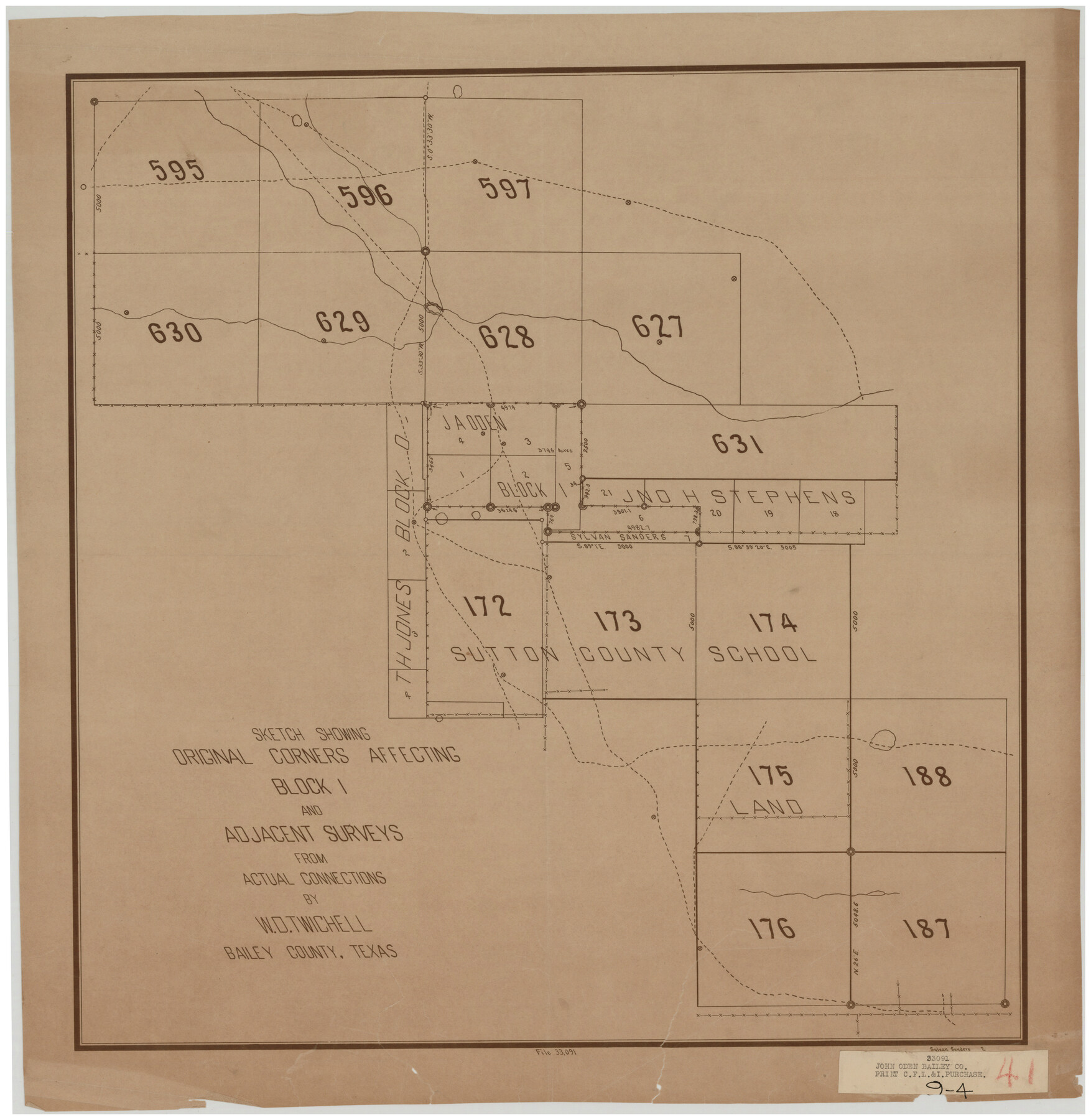
Sketch Showing Original Corners Affecting Block I and Adjacent Surveys from Actual Connections by W. D. Twichell
9-4
-
Map/Doc
90162
-
Collection
Twichell Survey Records
-
People and Organizations
Sylvan Sanders (Surveyor/Engineer)
-
Counties
Bailey
-
Height x Width
23.4 x 24.4 inches
59.4 x 62.0 cm
Part of: Twichell Survey Records
Plat Showing Parts of Blocks X, Y, and Z, W.D. and F. W. Johnson Subdivision

Print $20.00
- Digital $50.00
Plat Showing Parts of Blocks X, Y, and Z, W.D. and F. W. Johnson Subdivision
1955
Size 25.7 x 16.5 inches
Map/Doc 92501
[H. & G. N. Blocks 1-4 and Blocks C-19, C-20, 54, 55 and 56]
![91781, [H. & G. N. Blocks 1-4 and Blocks C-19, C-20, 54, 55 and 56], Twichell Survey Records](https://historictexasmaps.com/wmedia_w700/maps/91781-1.tif.jpg)
Print $20.00
- Digital $50.00
[H. & G. N. Blocks 1-4 and Blocks C-19, C-20, 54, 55 and 56]
Size 23.3 x 29.3 inches
Map/Doc 91781
[Sketch showing details along East line of Lipscomb County]
![89939, [Sketch showing details along East line of Lipscomb County], Twichell Survey Records](https://historictexasmaps.com/wmedia_w700/maps/89939-1.tif.jpg)
Print $40.00
- Digital $50.00
[Sketch showing details along East line of Lipscomb County]
Size 15.4 x 66.7 inches
Map/Doc 89939

[Township 3 North, Blocks 33 and 34, T. & P. RR. Company]
![92626, [Township 3 North, Blocks 33 and 34, T. & P. RR. Company], Twichell Survey Records](https://historictexasmaps.com/wmedia_w700/maps/92626-1.tif.jpg)
Print $20.00
- Digital $50.00
[Township 3 North, Blocks 33 and 34, T. & P. RR. Company]
Size 22.1 x 16.2 inches
Map/Doc 92626
[Jack County School Land, Limestone County School Land and surveys in vicinity]
![90433, [Jack County School Land, Limestone County School Land and surveys in vicinity], Twichell Survey Records](https://historictexasmaps.com/wmedia_w700/maps/90433-1.tif.jpg)
Print $3.00
- Digital $50.00
[Jack County School Land, Limestone County School Land and surveys in vicinity]
1892
Size 10.2 x 15.1 inches
Map/Doc 90433
[Southeast part of County]
![89956, [Southeast part of County], Twichell Survey Records](https://historictexasmaps.com/wmedia_w700/maps/89956-2.tif.jpg)
Print $40.00
- Digital $50.00
[Southeast part of County]
Size 37.1 x 48.2 inches
Map/Doc 89956
[Sketch showing unsurveyed land in West Texas as of 1902]
![89937, [Sketch showing unsurveyed land in West Texas as of 1902], Twichell Survey Records](https://historictexasmaps.com/wmedia_w700/maps/89937-1.tif.jpg)
Print $20.00
- Digital $50.00
[Sketch showing unsurveyed land in West Texas as of 1902]
Size 42.0 x 34.0 inches
Map/Doc 89937
[H. & G. N. Block 1]
![90941, [H. & G. N. Block 1], Twichell Survey Records](https://historictexasmaps.com/wmedia_w700/maps/90941-1.tif.jpg)
Print $20.00
- Digital $50.00
[H. & G. N. Block 1]
1873
Size 17.5 x 14.3 inches
Map/Doc 90941
Wellman Townsite Showing Survey 17

Print $3.00
- Digital $50.00
Wellman Townsite Showing Survey 17
Size 12.4 x 11.9 inches
Map/Doc 92885
Plat of tract surveyed for S. W. Inglish

Print $20.00
- Digital $50.00
Plat of tract surveyed for S. W. Inglish
1920
Size 18.2 x 6.7 inches
Map/Doc 90822
McAdams-Lokey Land

Print $20.00
- Digital $50.00
McAdams-Lokey Land
Size 15.8 x 19.5 inches
Map/Doc 92773
You may also like
Walker County Working Sketch 6

Print $20.00
- Digital $50.00
Walker County Working Sketch 6
1935
Size 30.8 x 40.6 inches
Map/Doc 72286
Bird's Eye View of Cuero, De Witt County, Texas

Print $20.00
Bird's Eye View of Cuero, De Witt County, Texas
1881
Size 18.4 x 25.5 inches
Map/Doc 89079
Flight Mission No. CRC-2R, Frame 63, Chambers County

Print $20.00
- Digital $50.00
Flight Mission No. CRC-2R, Frame 63, Chambers County
1956
Size 18.8 x 22.4 inches
Map/Doc 84734
Copy of Surveyor's Field Book, Morris Browning - In Blocks 7, 5 & 4, I&GNRRCo., Hutchinson and Carson Counties, Texas

Print $2.00
- Digital $50.00
Copy of Surveyor's Field Book, Morris Browning - In Blocks 7, 5 & 4, I&GNRRCo., Hutchinson and Carson Counties, Texas
1888
Size 6.9 x 8.8 inches
Map/Doc 62283
General Highway Map of Garza County, Texas

Print $20.00
- Digital $50.00
General Highway Map of Garza County, Texas
1950
Size 25.9 x 18.8 inches
Map/Doc 92646
[Township 2 North, Block 33]
![91209, [Township 2 North, Block 33], Twichell Survey Records](https://historictexasmaps.com/wmedia_w700/maps/91209-1.tif.jpg)
Print $3.00
- Digital $50.00
[Township 2 North, Block 33]
Size 11.2 x 13.4 inches
Map/Doc 91209
[Cotton Belt, St. Louis Southwestern Railway of Texas, Alignment through Smith County]
![64383, [Cotton Belt, St. Louis Southwestern Railway of Texas, Alignment through Smith County], General Map Collection](https://historictexasmaps.com/wmedia_w700/maps/64383.tif.jpg)
Print $20.00
- Digital $50.00
[Cotton Belt, St. Louis Southwestern Railway of Texas, Alignment through Smith County]
1903
Size 21.5 x 29.4 inches
Map/Doc 64383
Wood County Working Sketch 18

Print $20.00
- Digital $50.00
Wood County Working Sketch 18
1959
Size 31.5 x 27.6 inches
Map/Doc 62018
Wharton County Sketch File 10a

Print $20.00
- Digital $50.00
Wharton County Sketch File 10a
Size 11.0 x 19.0 inches
Map/Doc 12660
Hidalgo County Sketch File 7a

Print $4.00
- Digital $50.00
Hidalgo County Sketch File 7a
1886
Size 12.8 x 8.2 inches
Map/Doc 26405
Jasper County Working Sketch 7

Print $20.00
- Digital $50.00
Jasper County Working Sketch 7
1914
Size 24.2 x 26.3 inches
Map/Doc 66469
Stephens County Sketch File 10c

Print $6.00
- Digital $50.00
Stephens County Sketch File 10c
Size 7.8 x 11.5 inches
Map/Doc 37052