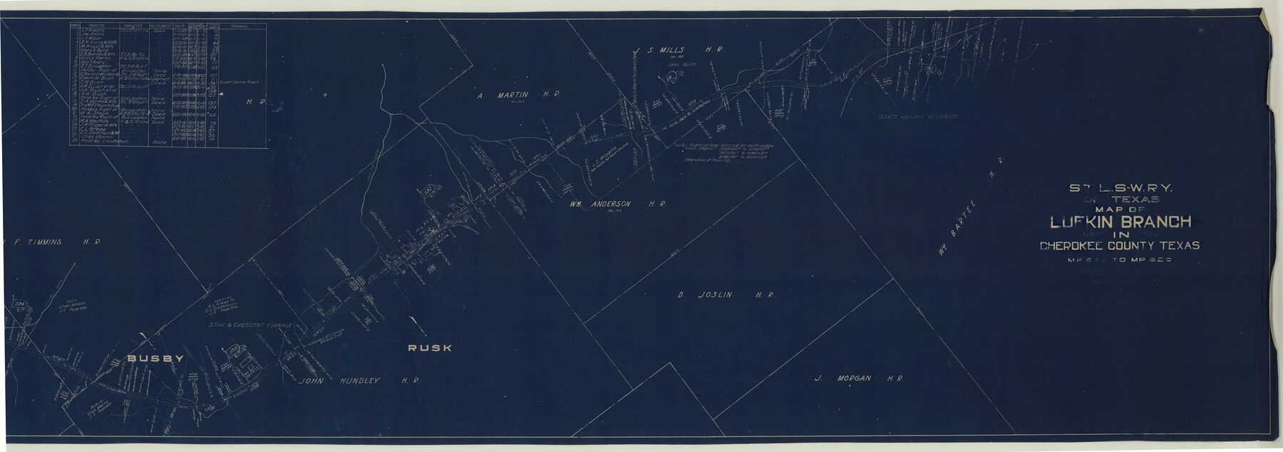
St. L. S-W. Ry. of Texas Map of Lufkin Branch in Cherokee County Texas
M.P. 590 to M.P. 620
Z-2-3
-
Map/Doc
64019
-
Collection
General Map Collection
-
Object Dates
1912 (Creation Date)
-
People and Organizations
W. T. Eaton (Surveyor/Engineer)
T. G. Johnson (Surveyor/Engineer)
-
Counties
Angelina Cherokee
-
Subjects
Railroads
-
Height x Width
22.7 x 64.3 inches
57.7 x 163.3 cm
-
Medium
blueprint/diazo
-
Scale
1" = 400 feet
-
Comments
Segment 1; see counter nos. 64021 through 64022 and 64790 for other segments. Segment 4; see counter nos. 64016 through 64018 for other segments.
-
Features
SLS
One Eye Creek
Busby
Dillard Creek
Part of: General Map Collection
Map of San Antonio Bay and Vicinity in Aransas and Calhoun Counties showing subdivision for mineral development

Print $40.00
- Digital $50.00
Map of San Antonio Bay and Vicinity in Aransas and Calhoun Counties showing subdivision for mineral development
1939
Size 40.4 x 62.8 inches
Map/Doc 2925
Map of San Augustine County

Print $40.00
- Digital $50.00
Map of San Augustine County
1901
Size 48.8 x 29.3 inches
Map/Doc 16807
Lamar County Sketch File 14

Print $4.00
- Digital $50.00
Lamar County Sketch File 14
1873
Size 12.7 x 8.1 inches
Map/Doc 29308
Harris County Working Sketch 103

Print $20.00
- Digital $50.00
Harris County Working Sketch 103
1980
Size 18.6 x 16.8 inches
Map/Doc 65995
Map of the River Sabine from its mouth on the Gulf of Mexico in the Sea to Logan's Ferry in Latitude 31°58'24" North

Print $40.00
- Digital $50.00
Map of the River Sabine from its mouth on the Gulf of Mexico in the Sea to Logan's Ferry in Latitude 31°58'24" North
1842
Size 67.6 x 30.6 inches
Map/Doc 87152
Flight Mission No. DQO-7K, Frame 110, Galveston County

Print $20.00
- Digital $50.00
Flight Mission No. DQO-7K, Frame 110, Galveston County
1952
Size 18.7 x 22.3 inches
Map/Doc 85125
Revised Map of Matagorda Bay and Vicinity in Matagorda and Calhoun Counties showing subdivision for mineral development

Print $40.00
- Digital $50.00
Revised Map of Matagorda Bay and Vicinity in Matagorda and Calhoun Counties showing subdivision for mineral development
1941
Size 44.3 x 60.0 inches
Map/Doc 2933
Reeves County Rolled Sketch 31

Print $20.00
- Digital $50.00
Reeves County Rolled Sketch 31
Size 21.7 x 27.9 inches
Map/Doc 7500
Baylor County Working Sketch 3

Print $20.00
- Digital $50.00
Baylor County Working Sketch 3
1929
Size 37.8 x 36.5 inches
Map/Doc 67288
Jefferson County Rolled Sketch 52

Print $40.00
- Digital $50.00
Jefferson County Rolled Sketch 52
Size 28.2 x 52.9 inches
Map/Doc 9308
Monterey Harbor, California

Print $20.00
- Digital $50.00
Monterey Harbor, California
1852
Size 15.7 x 13.8 inches
Map/Doc 97230
Zavala County Rolled Sketch 18

Print $20.00
- Digital $50.00
Zavala County Rolled Sketch 18
Size 39.4 x 27.3 inches
Map/Doc 8322
You may also like
Hardin County Sketch File 8

Print $8.00
- Digital $50.00
Hardin County Sketch File 8
1870
Size 12.6 x 8.1 inches
Map/Doc 25102
Deaf Smith County Sketch File Z

Print $34.00
- Digital $50.00
Deaf Smith County Sketch File Z
1903
Size 9.6 x 4.7 inches
Map/Doc 20651
Map of Hamilton County

Print $20.00
- Digital $50.00
Map of Hamilton County
1872
Size 15.0 x 21.9 inches
Map/Doc 4557
Limestone County Working Sketch 11

Print $20.00
- Digital $50.00
Limestone County Working Sketch 11
1922
Size 36.1 x 33.9 inches
Map/Doc 70561
Flight Mission No. DQO-2K, Frame 136, Galveston County

Print $20.00
- Digital $50.00
Flight Mission No. DQO-2K, Frame 136, Galveston County
1952
Size 18.8 x 22.6 inches
Map/Doc 85033
Flight Mission No. BQR-9K, Frame 49, Brazoria County

Print $20.00
- Digital $50.00
Flight Mission No. BQR-9K, Frame 49, Brazoria County
1952
Size 18.6 x 22.3 inches
Map/Doc 84053
Terrell County Working Sketch 35a

Print $20.00
- Digital $50.00
Terrell County Working Sketch 35a
1948
Size 26.4 x 45.1 inches
Map/Doc 62128
Jasper County Rolled Sketch 6

Print $20.00
- Digital $50.00
Jasper County Rolled Sketch 6
1948
Size 27.8 x 43.7 inches
Map/Doc 6353
United States

Print $20.00
- Digital $50.00
United States
1851
Size 10.8 x 15.1 inches
Map/Doc 93799
Arizona Chemical Co. O'Donnell Plant

Print $20.00
- Digital $50.00
Arizona Chemical Co. O'Donnell Plant
Size 30.2 x 33.2 inches
Map/Doc 92947
Coryell County

Print $20.00
- Digital $50.00
Coryell County
1880
Size 25.6 x 25.6 inches
Map/Doc 3444
Cameron County Boundary File 1

Print $14.00
- Digital $50.00
Cameron County Boundary File 1
Size 14.1 x 8.6 inches
Map/Doc 51087