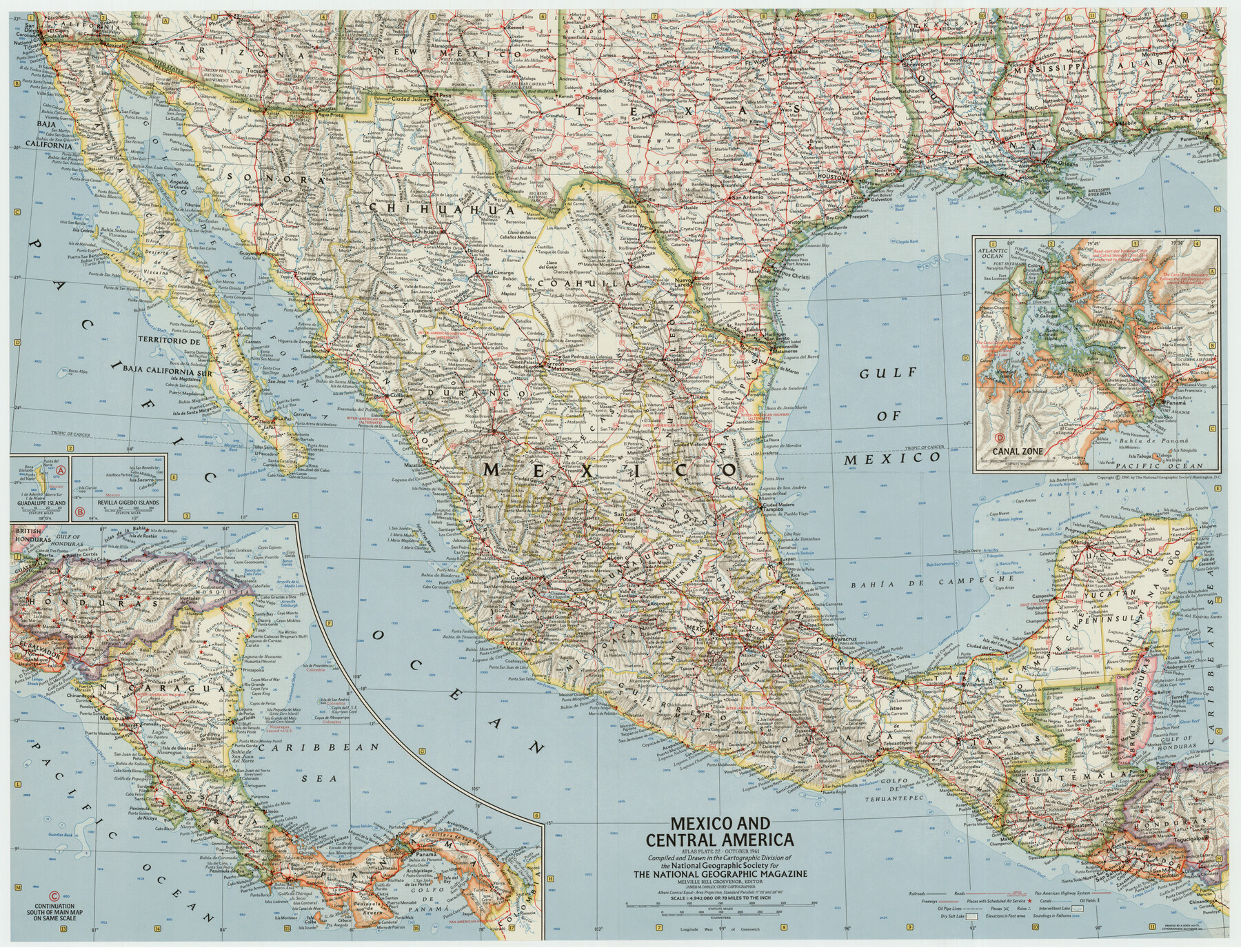
Mexico and Central America
-
Map/Doc
92363
-
Collection
Twichell Survey Records
-
Object Dates
10/1961 (Creation Date)
-
People and Organizations
National Geographic Society (Compiler)
-
Subjects
Central America Mexico
-
Height x Width
25.5 x 19.3 inches
64.8 x 49.0 cm
-
Comments
For research only. Not available for duplication from the GLO.
Part of: Twichell Survey Records
Sketch showing north boundary line of XIT lands and conflict of enclosure with L. & H. Blum land

Print $2.00
- Digital $50.00
Sketch showing north boundary line of XIT lands and conflict of enclosure with L. & H. Blum land
1906
Size 14.4 x 7.8 inches
Map/Doc 90519
[Working Sketch Showing Southwest Part of the County]
![91117, [Working Sketch Showing Southwest Part of the County], Twichell Survey Records](https://historictexasmaps.com/wmedia_w700/maps/91117-1.tif.jpg)
Print $2.00
- Digital $50.00
[Working Sketch Showing Southwest Part of the County]
1886
Size 14.9 x 9.0 inches
Map/Doc 91117
Caldwell County

Print $20.00
- Digital $50.00
Caldwell County
1896
Size 42.7 x 33.3 inches
Map/Doc 93039
Northeastern Half of Pecos County - Ownership Map

Print $40.00
- Digital $50.00
Northeastern Half of Pecos County - Ownership Map
Size 92.7 x 37.2 inches
Map/Doc 93197
[South Part of Glasscock County]
![90782, [South Part of Glasscock County], Twichell Survey Records](https://historictexasmaps.com/wmedia_w700/maps/90782-1.tif.jpg)
Print $20.00
- Digital $50.00
[South Part of Glasscock County]
Size 34.0 x 23.2 inches
Map/Doc 90782
[Parts of Blocks Z, L, M-21, M-15, and 46]
![91831, [Parts of Blocks Z, L, M-21, M-15, and 46], Twichell Survey Records](https://historictexasmaps.com/wmedia_w700/maps/91831-1.tif.jpg)
Print $20.00
- Digital $50.00
[Parts of Blocks Z, L, M-21, M-15, and 46]
Size 21.2 x 16.7 inches
Map/Doc 91831

Section Q Tech Memorial Park, Inc.

Print $20.00
- Digital $50.00
Section Q Tech Memorial Park, Inc.
1950
Size 28.5 x 31.6 inches
Map/Doc 92349
Brazos River Conservation and Reclamation District Official Boundary Line Survey

Print $20.00
- Digital $50.00
Brazos River Conservation and Reclamation District Official Boundary Line Survey
1931
Size 25.1 x 36.9 inches
Map/Doc 90125
University of Texas System University Lands

Print $20.00
- Digital $50.00
University of Texas System University Lands
Size 23.2 x 17.6 inches
Map/Doc 93235
[Sketch showing Midland and Martin County School Land Leagues]
![90295, [Sketch showing Midland and Martin County School Land Leagues], Twichell Survey Records](https://historictexasmaps.com/wmedia_w700/maps/90295-1.tif.jpg)
Print $20.00
- Digital $50.00
[Sketch showing Midland and Martin County School Land Leagues]
Size 14.0 x 18.0 inches
Map/Doc 90295

You may also like
Donley County Sketch File 6

Print $16.00
- Digital $50.00
Donley County Sketch File 6
1881
Size 12.9 x 8.5 inches
Map/Doc 21230
Lynn County Rolled Sketch 13

Print $20.00
- Digital $50.00
Lynn County Rolled Sketch 13
1926
Size 18.6 x 24.4 inches
Map/Doc 6650
Jeff Davis County Working Sketch 18

Print $20.00
- Digital $50.00
Jeff Davis County Working Sketch 18
1956
Size 31.3 x 21.5 inches
Map/Doc 66513

[Blocks 24, B9, 3KA]
![90326, [Blocks 24, B9, 3KA], Twichell Survey Records](https://historictexasmaps.com/wmedia_w700/maps/90326-1.tif.jpg)
Print $20.00
- Digital $50.00
[Blocks 24, B9, 3KA]
Size 18.2 x 14.0 inches
Map/Doc 90326
General Highway Map, Wheeler County, Texas

Print $20.00
General Highway Map, Wheeler County, Texas
1961
Size 18.1 x 24.9 inches
Map/Doc 79708
Bexar County Rolled Sketch 4

Print $20.00
- Digital $50.00
Bexar County Rolled Sketch 4
Size 24.3 x 36.8 inches
Map/Doc 5137
Bastrop County Boundary File 3

Print $48.00
- Digital $50.00
Bastrop County Boundary File 3
1925
Size 11.3 x 8.7 inches
Map/Doc 50320
Flight Mission No. CGI-3N, Frame 46, Cameron County

Print $20.00
- Digital $50.00
Flight Mission No. CGI-3N, Frame 46, Cameron County
1954
Size 18.7 x 22.2 inches
Map/Doc 84552
Crockett County Working Sketch 1

Print $20.00
- Digital $50.00
Crockett County Working Sketch 1
Size 20.7 x 16.7 inches
Map/Doc 68334
Cameron County State Real Property Sketch 2

Print $20.00
- Digital $50.00
Cameron County State Real Property Sketch 2
1996
Size 25.4 x 39.1 inches
Map/Doc 80132
Winkler County Sketch File 15

Print $10.00
- Digital $50.00
Winkler County Sketch File 15
1944
Size 14.3 x 8.6 inches
Map/Doc 40488