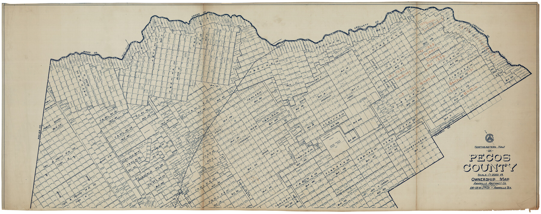
Northeastern Half of Pecos County - Ownership Map
-
Map/Doc
93197
-
Collection
Twichell Survey Records
-
People and Organizations
Amarillo Abstract Co. (Publisher)
-
Counties
Pecos
-
Height x Width
92.7 x 37.2 inches
235.5 x 94.5 cm
Part of: Twichell Survey Records
Parkland Place

Print $20.00
- Digital $50.00
Parkland Place
1928
Size 15.9 x 13.0 inches
Map/Doc 92278
[In Northwest 1/4 of County in the vicinity of the John Walker Survey]
![90898, [In Northwest 1/4 of County in the vicinity of the John Walker Survey], Twichell Survey Records](https://historictexasmaps.com/wmedia_w700/maps/90898-1.tif.jpg)
Print $20.00
- Digital $50.00
[In Northwest 1/4 of County in the vicinity of the John Walker Survey]
Size 14.4 x 24.3 inches
Map/Doc 90898
San Augustine County School Land for sale by Lubbock Irrigation Company

Print $20.00
- Digital $50.00
San Augustine County School Land for sale by Lubbock Irrigation Company
Size 24.0 x 25.2 inches
Map/Doc 92874
[Public School Land Blocks B1 and B7]
![91974, [Public School Land Blocks B1 and B7], Twichell Survey Records](https://historictexasmaps.com/wmedia_w700/maps/91974-1.tif.jpg)
Print $20.00
- Digital $50.00
[Public School Land Blocks B1 and B7]
Size 22.9 x 14.8 inches
Map/Doc 91974
[Section 2, Block 5, Dawson County, Texas]
![92617, [Section 2, Block 5, Dawson County, Texas], Twichell Survey Records](https://historictexasmaps.com/wmedia_w700/maps/92617-1.tif.jpg)
Print $2.00
- Digital $50.00
[Section 2, Block 5, Dawson County, Texas]
Size 9.2 x 12.3 inches
Map/Doc 92617
Sketch Showing Boundary Between Randall and Deaf Smith Counties

Print $20.00
- Digital $50.00
Sketch Showing Boundary Between Randall and Deaf Smith Counties
Size 13.4 x 33.3 inches
Map/Doc 91832
[Blk. O1, W. H. Godair]
![90632, [Blk. O1, W. H. Godair], Twichell Survey Records](https://historictexasmaps.com/wmedia_w700/maps/90632-1.tif.jpg)
Print $20.00
- Digital $50.00
[Blk. O1, W. H. Godair]
1913
Size 30.1 x 10.3 inches
Map/Doc 90632
[Crocket County School Land along Bailey and Lamb County Line]
![90197, [Crocket County School Land along Bailey and Lamb County Line], Twichell Survey Records](https://historictexasmaps.com/wmedia_w700/maps/90197-1.tif.jpg)
Print $20.00
- Digital $50.00
[Crocket County School Land along Bailey and Lamb County Line]
Size 26.8 x 18.9 inches
Map/Doc 90197
[Strip Map showing T. & P. connecting lines]
![93182, [Strip Map showing T. & P. connecting lines], Twichell Survey Records](https://historictexasmaps.com/wmedia_w700/maps/93182-1.tif.jpg)
Print $40.00
- Digital $50.00
[Strip Map showing T. & P. connecting lines]
Size 13.6 x 92.6 inches
Map/Doc 93182
Working Sketch in Childress County

Print $20.00
- Digital $50.00
Working Sketch in Childress County
1910
Size 6.6 x 23.3 inches
Map/Doc 90425

R. S. Dod Meanders

Print $20.00
- Digital $50.00
R. S. Dod Meanders
Size 19.0 x 13.2 inches
Map/Doc 91675
You may also like
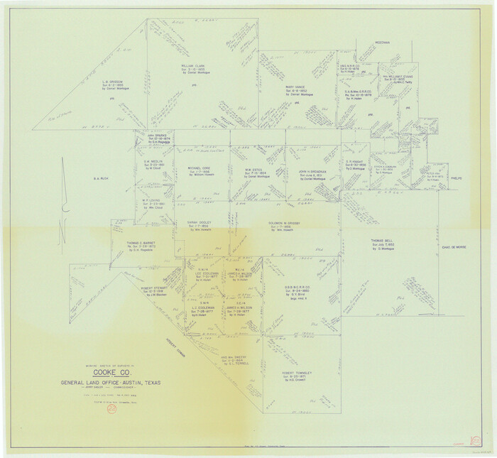
Cooke County Working Sketch 22
Print $20.00
- Digital $50.00
Cooke County Working Sketch 22
1963
Size 37.0 x 40.2 inches
Map/Doc 68259
Kimble County Rolled Sketch 36

Print $20.00
- Digital $50.00
Kimble County Rolled Sketch 36
Size 27.5 x 22.4 inches
Map/Doc 6526
Wharton County Sketch File 26

Print $4.00
- Digital $50.00
Wharton County Sketch File 26
1895
Size 11.0 x 8.8 inches
Map/Doc 39990
Amistad International Reservoir on Rio Grande 79

Print $20.00
- Digital $50.00
Amistad International Reservoir on Rio Grande 79
1949
Size 28.6 x 40.3 inches
Map/Doc 75508
Galveston County Sketch File 12

Print $6.00
- Digital $50.00
Galveston County Sketch File 12
1886
Size 15.7 x 11.4 inches
Map/Doc 23380
Trinity River, Slate Rock Ferry Sheet/East Fork of Trinity River

Print $6.00
- Digital $50.00
Trinity River, Slate Rock Ferry Sheet/East Fork of Trinity River
1922
Size 35.1 x 34.3 inches
Map/Doc 65185
Wise County Rolled Sketch 7

Print $20.00
- Digital $50.00
Wise County Rolled Sketch 7
Size 23.9 x 18.4 inches
Map/Doc 8281
Gulf Coast of the United States, Key West to Rio Grande

Print $20.00
- Digital $50.00
Gulf Coast of the United States, Key West to Rio Grande
1863
Size 27.5 x 18.2 inches
Map/Doc 72665
Flight Mission No. DIX-5P, Frame 152, Aransas County

Print $20.00
- Digital $50.00
Flight Mission No. DIX-5P, Frame 152, Aransas County
1956
Size 17.8 x 18.6 inches
Map/Doc 83814
Crockett County Working Sketch 1

Print $20.00
- Digital $50.00
Crockett County Working Sketch 1
Size 20.7 x 16.7 inches
Map/Doc 68334
Brooks County Working Sketch 18

Print $20.00
- Digital $50.00
Brooks County Working Sketch 18
1981
Size 20.6 x 32.4 inches
Map/Doc 67802
Bandera County Sketch File 23

Print $40.00
- Digital $50.00
Bandera County Sketch File 23
1881
Size 16.1 x 13.7 inches
Map/Doc 10895