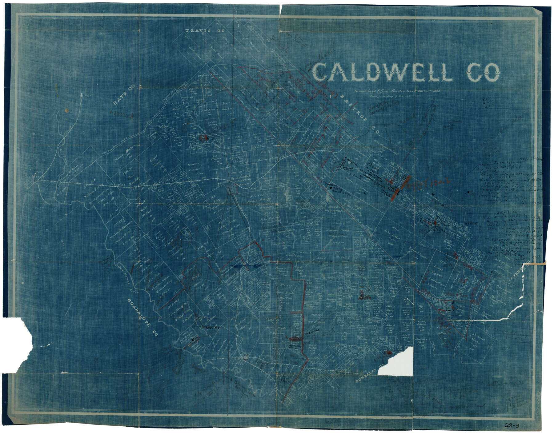
Caldwell County
28-3
- 
                          Map/Doc
93039
 - 
                            Collection
Twichell Survey Records
 - 
                            Object Dates
12/23/1896 (Creation Date)
 - 
                            Counties
Caldwell
 - 
                            Subjects
County
 - 
                            Height x Width
42.7 x 33.3 inches
108.5 x 84.6 cm
 - 
                            Comments
Traced from map of Dec. 1895.
 
Part of: Twichell Survey Records
            Map of Capitol Syndicate Subdivisions of Capitol Land Reservation Leagues


                                            Print $40.00                    
                                             -                         Digital $50.00                                    
                Map of Capitol Syndicate Subdivisions of Capitol Land Reservation Leagues
1906
Size 44.6 x 72.6 inches
                                Map/Doc 93131
            
            [North part of University Lands Block 20]


                                            Print $2.00                    
                                             -                         Digital $50.00                                    
                [North part of University Lands Block 20]
Size 10.8 x 8.3 inches
                                Map/Doc 91581
            
            Working Sketch Compiled From Original Field Notes Showing Surveys in Reagan and Irion Counties


                                            Print $20.00                    
                                             -                         Digital $50.00                                    
                Working Sketch Compiled From Original Field Notes Showing Surveys in Reagan and Irion Counties
Size 36.2 x 20.2 inches
                                Map/Doc 92331
            
            Texas Boundary Line


                                            Print $20.00                    
                                             -                         Digital $50.00                                    
                Texas Boundary Line
Size 21.3 x 12.0 inches
                                Map/Doc 92079
            
            Working Drawing Compiled from Field Notes of the Sand Hills Area - Crane Co. Tex.


                                            Print $20.00                    
                                             -                         Digital $50.00                                    
                Working Drawing Compiled from Field Notes of the Sand Hills Area - Crane Co. Tex.
Size 43.5 x 30.8 inches
                                Map/Doc 90461
            
            Stanton Acres, a Subdivision of Tracts 2 and 3, Block 1; and Tract 1, Block 2]


                                            Print $3.00                    
                                             -                         Digital $50.00                                    
                Stanton Acres, a Subdivision of Tracts 2 and 3, Block 1; and Tract 1, Block 2]
Size 9.4 x 11.8 inches
                                Map/Doc 91336
            
            [H. & G. N. Block 8 showing Llano and Espuella fence lines]


                                            Print $2.00                    
                                             -                         Digital $50.00                                    
                [H. & G. N. Block 8 showing Llano and Espuella fence lines]
Size 6.2 x 9.7 inches
                                Map/Doc 90374
            
            Sketch Terrell and Val Verde Counties


                                            Print $20.00                    
                                             -                         Digital $50.00                                    
                Sketch Terrell and Val Verde Counties
1932
Size 41.9 x 18.3 inches
                                Map/Doc 91947
            
            [Notes and rough sketch of survey 6, Block 16 and survey 19 1/2, Block 19]


                                            Print $20.00                    
                                             -                         Digital $50.00                                    
                [Notes and rough sketch of survey 6, Block 16 and survey 19 1/2, Block 19]
Size 23.8 x 11.8 inches
                                Map/Doc 93053
            
            [Blocks 57, 56, 55, 54, 76, 53]


                                            Print $20.00                    
                                             -                         Digital $50.00                                    
                [Blocks 57, 56, 55, 54, 76, 53]
Size 36.6 x 23.1 inches
                                Map/Doc 92928
            You may also like
            Map of the Houston and G. N. R.R. and lands adjacent, from Troupe to the Texas Pacific R.R.


                                            Print $40.00                    
                                             -                         Digital $50.00                                    
                Map of the Houston and G. N. R.R. and lands adjacent, from Troupe to the Texas Pacific R.R.
Size 21.2 x 92.0 inches
                                Map/Doc 64627
            
            Map of Copano, St. Charles, Aransas & Red Fish Bays in Aransas & Nueces Counties showing subdivision thereof for Mineral Development


                                            Print $20.00                    
                                             -                         Digital $50.00                                    
                Map of Copano, St. Charles, Aransas & Red Fish Bays in Aransas & Nueces Counties showing subdivision thereof for Mineral Development
1939
Size 35.9 x 34.4 inches
                                Map/Doc 2296
            
            Uvalde County Working Sketch 34


                                            Print $20.00                    
                                             -                         Digital $50.00                                    
                Uvalde County Working Sketch 34
1963
Size 31.6 x 42.8 inches
                                Map/Doc 72104
            
            Flight Mission No. DIX-3P, Frame 139, Aransas County


                                            Print $20.00                    
                                             -                         Digital $50.00                                    
                Flight Mission No. DIX-3P, Frame 139, Aransas County
1956
Size 17.8 x 18.6 inches
                                Map/Doc 83769
            
            Carta General de la República Mexicana formada por Antonio García y Cubas


                                            Print $40.00                    
                                    
                Carta General de la República Mexicana formada por Antonio García y Cubas
1863
Size 48.7 x 57.1 inches
                                Map/Doc 95307
            
            Boundary and Ownership map, Laguna Atascosa National Wildlife Refuge, Cameron and Willacy Counties, Texas


                                            Print $40.00                    
                                             -                         Digital $50.00                                    
                Boundary and Ownership map, Laguna Atascosa National Wildlife Refuge, Cameron and Willacy Counties, Texas
Size 72.7 x 43.0 inches
                                Map/Doc 60396
            
            Nolan County Working Sketch Graphic Index


                                            Print $20.00                    
                                             -                         Digital $50.00                                    
                Nolan County Working Sketch Graphic Index
1935
Size 41.6 x 36.9 inches
                                Map/Doc 76654
            
            Flight Mission No. DQO-12K, Frame 42, Galveston County


                                            Print $20.00                    
                                             -                         Digital $50.00                                    
                Flight Mission No. DQO-12K, Frame 42, Galveston County
1952
Size 18.6 x 22.3 inches
                                Map/Doc 85232
            
            Amistad International Reservoir on Rio Grande 90


                                            Print $20.00                    
                                             -                         Digital $50.00                                    
                Amistad International Reservoir on Rio Grande 90
1950
Size 28.5 x 39.7 inches
                                Map/Doc 75520
            
            Hardin County Working Sketch 27


                                            Print $20.00                    
                                             -                         Digital $50.00                                    
                Hardin County Working Sketch 27
1954
Size 22.9 x 27.9 inches
                                Map/Doc 63425
            
            Presidio County Rolled Sketch BB


                                            Print $20.00                    
                                             -                         Digital $50.00                                    
                Presidio County Rolled Sketch BB
1937
Size 26.3 x 27.1 inches
                                Map/Doc 7407
            
            Baylor County Rolled Sketch 10


                                            Print $20.00                    
                                             -                         Digital $50.00                                    
                Baylor County Rolled Sketch 10
Size 28.0 x 14.0 inches
                                Map/Doc 5127