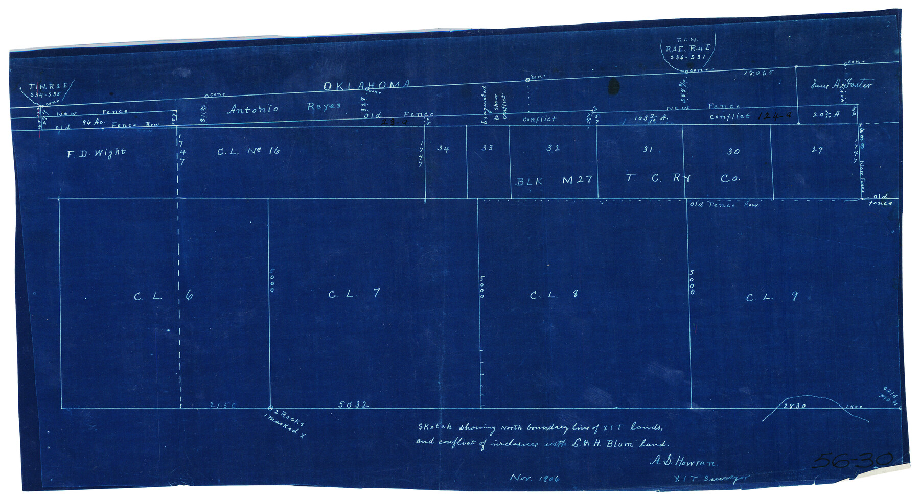
Sketch showing north boundary line of XIT lands and conflict of enclosure with L. & H. Blum land
56-30
-
Map/Doc
90519
-
Collection
Twichell Survey Records
-
Object Dates
11/1906 (Creation Date)
-
People and Organizations
A.S. Howren (Surveyor/Engineer)
-
Counties
Dallam
-
Height x Width
14.4 x 7.8 inches
36.6 x 19.8 cm
Part of: Twichell Survey Records

[Field Notes attached to Sketch of North Line of Deaf Smith County and South Line of Oldham County]
![91407, [Field Notes attached to Sketch of North Line of Deaf Smith County and South Line of Oldham County], Twichell Survey Records](https://historictexasmaps.com/wmedia_w700/maps/91407-1.tif.jpg)
Print $20.00
- Digital $50.00
[Field Notes attached to Sketch of North Line of Deaf Smith County and South Line of Oldham County]
1894
Size 40.6 x 20.0 inches
Map/Doc 91407
[Chas. L. Durocher and Surrounding Surveys]
![90815, [Chas. L. Durocher and Surrounding Surveys], Twichell Survey Records](https://historictexasmaps.com/wmedia_w700/maps/90815-2.tif.jpg)
Print $20.00
- Digital $50.00
[Chas. L. Durocher and Surrounding Surveys]
1919
Size 19.7 x 27.4 inches
Map/Doc 90815
First Installment Gordon Addition to Idalou

Print $20.00
- Digital $50.00
First Installment Gordon Addition to Idalou
1954
Size 22.8 x 10.8 inches
Map/Doc 92828
[Blocks 36 and 37, Townships 1S-5S]
![93213, [Blocks 36 and 37, Townships 1S-5S], Twichell Survey Records](https://historictexasmaps.com/wmedia_w700/maps/93213-1.tif.jpg)
Print $40.00
- Digital $50.00
[Blocks 36 and 37, Townships 1S-5S]
Size 28.9 x 83.7 inches
Map/Doc 93213
[Sketch of part of G. & M. Block 5]
![93077, [Sketch of part of G. & M. Block 5], Twichell Survey Records](https://historictexasmaps.com/wmedia_w700/maps/93077-1.tif.jpg)
Print $3.00
- Digital $50.00
[Sketch of part of G. & M. Block 5]
Size 17.7 x 9.4 inches
Map/Doc 93077
[Township 5-S, Blocks 36, 37 & 38]
![92292, [Township 5-S, Blocks 36, 37 & 38], Twichell Survey Records](https://historictexasmaps.com/wmedia_w700/maps/92292-1.tif.jpg)
Print $20.00
- Digital $50.00
[Township 5-S, Blocks 36, 37 & 38]
1952
Size 27.7 x 26.6 inches
Map/Doc 92292
General Highway Map of Gaines County, Texas

Print $20.00
- Digital $50.00
General Highway Map of Gaines County, Texas
1951
Size 19.0 x 26.2 inches
Map/Doc 92644
Map of Escarpment Section through Webb County, Texas (South half of Webb County)

Print $40.00
- Digital $50.00
Map of Escarpment Section through Webb County, Texas (South half of Webb County)
1925
Size 43.3 x 76.2 inches
Map/Doc 93163

Section 39 Block Y

Print $20.00
- Digital $50.00
Section 39 Block Y
Size 23.9 x 19.4 inches
Map/Doc 92463
[H. & G. N. Block 28]
![90357, [H. & G. N. Block 28], Twichell Survey Records](https://historictexasmaps.com/wmedia_w700/maps/90357-1.tif.jpg)
Print $20.00
- Digital $50.00
[H. & G. N. Block 28]
1903
Size 21.9 x 28.8 inches
Map/Doc 90357
You may also like

Map of the Texas & Pacific Railway and connections

Print $20.00
- Digital $50.00
Map of the Texas & Pacific Railway and connections
1897
Size 19.8 x 24.6 inches
Map/Doc 93958
Railroad Track Map, H&TCRRCo., Falls County, Texas

Print $4.00
- Digital $50.00
Railroad Track Map, H&TCRRCo., Falls County, Texas
1918
Size 11.7 x 18.5 inches
Map/Doc 62858
Rusk County Rolled Sketch 13

Print $20.00
- Digital $50.00
Rusk County Rolled Sketch 13
Size 30.1 x 26.4 inches
Map/Doc 7548
Harris County Boundary File 39 (16)

Print $6.00
- Digital $50.00
Harris County Boundary File 39 (16)
Size 10.0 x 8.0 inches
Map/Doc 54354
Sulphur River, Boxelder Sheet/Cuthand Creek

Print $20.00
- Digital $50.00
Sulphur River, Boxelder Sheet/Cuthand Creek
1922
Size 29.5 x 25.1 inches
Map/Doc 65156
Rusk County Working Sketch 32

Print $20.00
- Digital $50.00
Rusk County Working Sketch 32
1919
Size 16.7 x 17.1 inches
Map/Doc 63669
Refugio County NRC Article 33.136 Location Key Sheet

Print $20.00
- Digital $50.00
Refugio County NRC Article 33.136 Location Key Sheet
1979
Size 27.0 x 23.0 inches
Map/Doc 77034
Brewster County Rolled Sketch 11

Print $20.00
- Digital $50.00
Brewster County Rolled Sketch 11
1881
Size 24.9 x 23.1 inches
Map/Doc 5191
Galveston County NRC Article 33.136 Sketch 46

Print $23.00
- Digital $50.00
Galveston County NRC Article 33.136 Sketch 46
2007
Size 24.6 x 36.0 inches
Map/Doc 87936
Harris County Historic Topographic 24

Print $20.00
- Digital $50.00
Harris County Historic Topographic 24
1916
Size 29.2 x 22.9 inches
Map/Doc 65835
Lavaca County Rolled Sketch 3

Print $20.00
- Digital $50.00
Lavaca County Rolled Sketch 3
1959
Size 42.8 x 32.8 inches
Map/Doc 9419