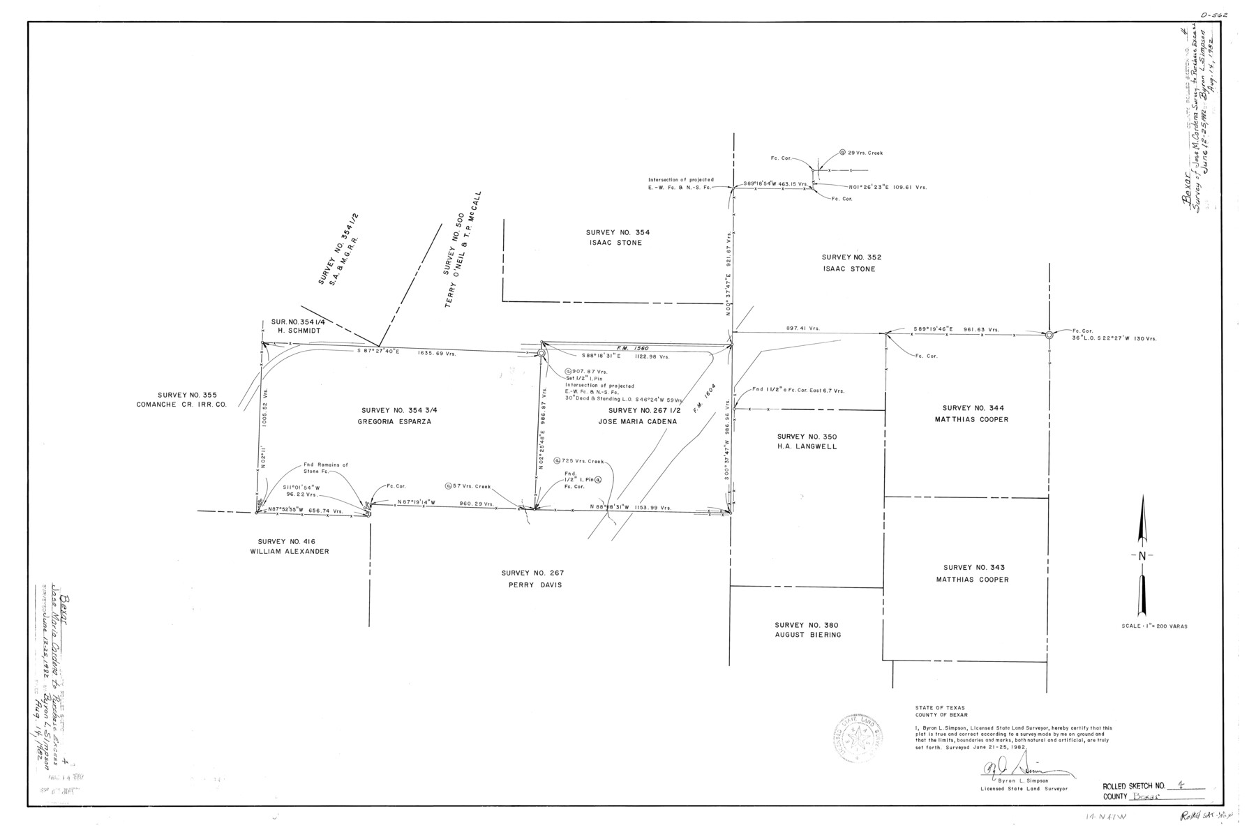
Bexar County Rolled Sketch 4
[Survey of Jose M. Cardena survey to purchase excess]
-
Map/Doc
5137
-
Collection
General Map Collection
-
Object Dates
1982/6/25 (Survey Date)
1982/8/14 (File Date)
-
People and Organizations
Byron L. Simpson (Surveyor/Engineer)
-
Counties
Bexar
-
Subjects
Surveying Rolled Sketch
-
Height x Width
24.3 x 36.8 inches
61.7 x 93.5 cm
-
Medium
mylar, print
-
Scale
1" = 200 varas
-
Comments
See Bexar County Rolled Sketch 4A (5138) and Bexar County Rolled Sketch 4B (5139) for related sketches.
Related maps
Bexar County Rolled Sketch 4A

Print $20.00
- Digital $50.00
Bexar County Rolled Sketch 4A
1982
Size 24.4 x 36.7 inches
Map/Doc 5138
Bexar County Rolled Sketch 4B

Print $20.00
- Digital $50.00
Bexar County Rolled Sketch 4B
1989
Size 24.3 x 36.7 inches
Map/Doc 5139
Part of: General Map Collection
Gillespie County Rolled Sketch 5

Print $20.00
- Digital $50.00
Gillespie County Rolled Sketch 5
1994
Size 25.7 x 20.6 inches
Map/Doc 6012
Sutton County Sketch File 26

Print $20.00
- Digital $50.00
Sutton County Sketch File 26
1929
Size 19.6 x 14.8 inches
Map/Doc 12383
[Sketch & Field Note Calls of Pecos, Terrell & Val Verde Counties, Texas]
![1720, [Sketch & Field Note Calls of Pecos, Terrell & Val Verde Counties, Texas], General Map Collection](https://historictexasmaps.com/wmedia_w700/pdf_converted_jpg/qi_pdf_thumbnail_734.jpg)
Print $20.00
- Digital $50.00
[Sketch & Field Note Calls of Pecos, Terrell & Val Verde Counties, Texas]
1915
Size 19.4 x 24.2 inches
Map/Doc 1720
Matagorda County Rolled Sketch 20

Print $20.00
- Digital $50.00
Matagorda County Rolled Sketch 20
1938
Size 25.1 x 30.6 inches
Map/Doc 6688
Bexar County Sketch File 60

Print $4.00
- Digital $50.00
Bexar County Sketch File 60
2009
Size 11.0 x 8.5 inches
Map/Doc 93669
Trinity River, Walker's Lake Sheet/Richland Creek

Print $20.00
- Digital $50.00
Trinity River, Walker's Lake Sheet/Richland Creek
1931
Size 25.9 x 41.2 inches
Map/Doc 65226
Rusk County Working Sketch 28

Print $20.00
- Digital $50.00
Rusk County Working Sketch 28
1934
Size 24.2 x 18.3 inches
Map/Doc 63664
Map of Surveys made in Fisher and Miller's Colony

Print $40.00
- Digital $50.00
Map of Surveys made in Fisher and Miller's Colony
1848
Size 48.4 x 57.7 inches
Map/Doc 16830
Hays County Rolled Sketch 26

Print $20.00
- Digital $50.00
Hays County Rolled Sketch 26
1943
Size 27.7 x 25.6 inches
Map/Doc 6182
Travis County Sketch File 67

Print $10.00
- Digital $50.00
Travis County Sketch File 67
1951
Size 14.3 x 9.0 inches
Map/Doc 38446
Lavaca County Sketch File 9

Print $22.00
- Digital $50.00
Lavaca County Sketch File 9
Size 7.2 x 13.4 inches
Map/Doc 29646
Garza County Rolled Sketch R-2

Print $40.00
- Digital $50.00
Garza County Rolled Sketch R-2
Size 36.0 x 50.2 inches
Map/Doc 9046
You may also like
Political Essay on the Kingdom of New Spain Vol. 4

Political Essay on the Kingdom of New Spain Vol. 4
1822
Map/Doc 97389
Liberty County Working Sketch 28

Print $20.00
- Digital $50.00
Liberty County Working Sketch 28
1942
Size 22.4 x 23.2 inches
Map/Doc 70487
Palo Pinto County Sketch File B

Print $20.00
- Digital $50.00
Palo Pinto County Sketch File B
Size 45.3 x 45.5 inches
Map/Doc 10566
Kleberg County Aerial Photograph Index Sheet 5

Print $20.00
- Digital $50.00
Kleberg County Aerial Photograph Index Sheet 5
1956
Size 19.5 x 23.5 inches
Map/Doc 83722
No. 1 - Survey for a road from the Brazo Santiago to the Rio Grande

Print $20.00
- Digital $50.00
No. 1 - Survey for a road from the Brazo Santiago to the Rio Grande
1847
Size 18.3 x 27.1 inches
Map/Doc 72876
Mills County Working Sketch 5

Print $3.00
- Digital $50.00
Mills County Working Sketch 5
1914
Size 13.1 x 10.8 inches
Map/Doc 71035
Polk County Working Sketch 36

Print $20.00
- Digital $50.00
Polk County Working Sketch 36
1963
Size 28.4 x 38.1 inches
Map/Doc 71653
Childress County Sketch File 16b

Print $6.00
- Digital $50.00
Childress County Sketch File 16b
1884
Size 12.6 x 8.1 inches
Map/Doc 18305
El Paso County Sketch File 35 (3)

Print $40.00
- Digital $50.00
El Paso County Sketch File 35 (3)
1886
Size 12.8 x 8.3 inches
Map/Doc 22179
Orange County Working Sketch 7

Print $20.00
- Digital $50.00
Orange County Working Sketch 7
1922
Size 21.9 x 31.9 inches
Map/Doc 71339
Garza County Sketch File H1

Print $24.00
- Digital $50.00
Garza County Sketch File H1
Size 7.6 x 8.8 inches
Map/Doc 24030
San Patricio County Working Sketch 3

Print $20.00
- Digital $50.00
San Patricio County Working Sketch 3
1917
Size 22.2 x 42.7 inches
Map/Doc 63765