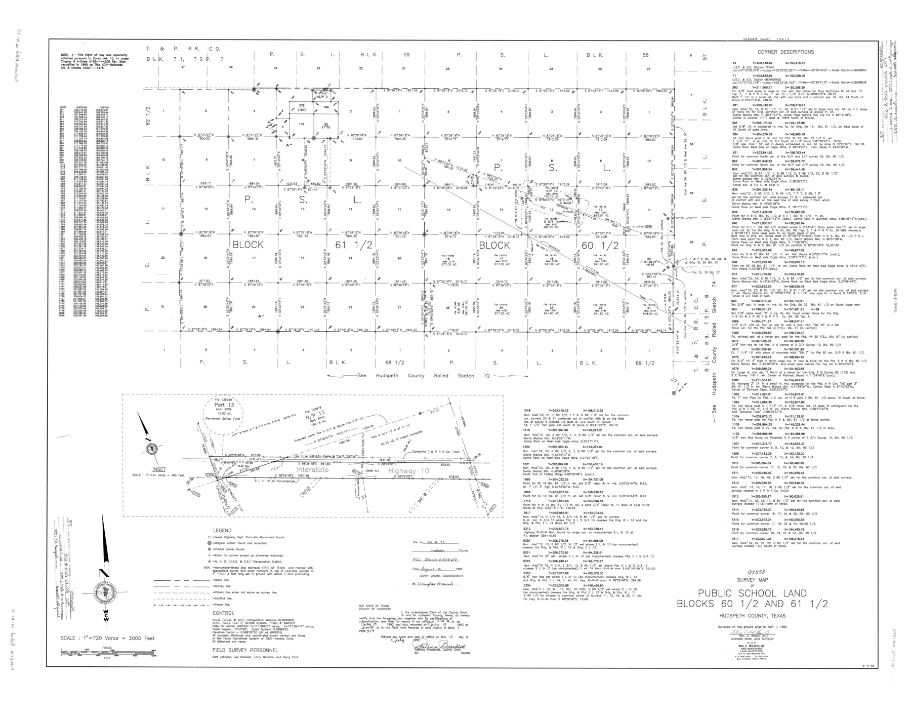
Hudspeth County Rolled Sketch 73
Survey map of Public School Land Blocks 60 1/2 and 61 1/2
-
Map/Doc
9236
-
Collection
General Map Collection
-
Object Dates
1992/4/1 (Creation Date)
1992/8/31 (File Date)
-
People and Organizations
Wm. C. Wilson, Jr. (Surveyor/Engineer)
Bart Johnson (Chainman/Field Personnel)
Lee Dressler (Chainman/Field Personnel)
Larry McGuire (Chainman/Field Personnel)
Kerry Flint (Chainman/Field Personnel)
-
Counties
Hudspeth
-
Subjects
Surveying Rolled Sketch
-
Height x Width
38.9 x 49.3 inches
98.8 x 125.2 cm
-
Medium
mylar, print
-
Scale
1" = 720 varas
Part of: General Map Collection
Brazoria County Sketch File 11

Print $4.00
- Digital $50.00
Brazoria County Sketch File 11
Size 10.5 x 8.5 inches
Map/Doc 14965
Galveston County Working Sketch 24

Print $20.00
- Digital $50.00
Galveston County Working Sketch 24
1939
Size 16.6 x 19.6 inches
Map/Doc 69361

Dickens County Boundary File 5

Print $12.00
- Digital $50.00
Dickens County Boundary File 5
Size 10.8 x 8.2 inches
Map/Doc 52554
Aransas County Rolled Sketch 28

Print $20.00
- Digital $50.00
Aransas County Rolled Sketch 28
1987
Size 24.5 x 30.9 inches
Map/Doc 77496
Flight Mission No. CGI-3N, Frame 46, Cameron County

Print $20.00
- Digital $50.00
Flight Mission No. CGI-3N, Frame 46, Cameron County
1954
Size 18.7 x 22.2 inches
Map/Doc 84552
Val Verde County Working Sketch 47

Print $20.00
- Digital $50.00
Val Verde County Working Sketch 47
1946
Size 41.4 x 42.6 inches
Map/Doc 72182
Reeves County Sketch File 18

Print $40.00
- Digital $50.00
Reeves County Sketch File 18
1926
Size 22.2 x 9.4 inches
Map/Doc 35210

Flight Mission No. DAG-21K, Frame 35, Matagorda County

Print $20.00
- Digital $50.00
Flight Mission No. DAG-21K, Frame 35, Matagorda County
1952
Size 18.6 x 22.4 inches
Map/Doc 86402
Le Vieux Mexique ou Nouvelle Espagne avec les costes de la Floride faisant partie de l'Amerique Septentrionale

Print $20.00
- Digital $50.00
Le Vieux Mexique ou Nouvelle Espagne avec les costes de la Floride faisant partie de l'Amerique Septentrionale
1702
Size 11.2 x 15.5 inches
Map/Doc 95922
Fractional Township No. 8 South Range No. 11 East of the Indian Meridian, Indian Territory

Print $20.00
- Digital $50.00
Fractional Township No. 8 South Range No. 11 East of the Indian Meridian, Indian Territory
1896
Size 19.3 x 24.4 inches
Map/Doc 75222
You may also like
Texas Intracoastal Waterway, Aransas Bay to Aransas Pass

Print $20.00
- Digital $50.00
Texas Intracoastal Waterway, Aransas Bay to Aransas Pass
1957
Size 27.5 x 39.1 inches
Map/Doc 73436
Palo Pinto County

Print $20.00
- Digital $50.00
Palo Pinto County
Size 23.7 x 18.6 inches
Map/Doc 3936
Nueces County Rolled Sketch 77

Print $55.00
Nueces County Rolled Sketch 77
1982
Size 24.6 x 36.3 inches
Map/Doc 6938
Northwest Part of Webb County

Print $40.00
- Digital $50.00
Northwest Part of Webb County
1984
Size 42.6 x 52.2 inches
Map/Doc 73319
Floyd County Rolled Sketch 7

Print $3.00
- Digital $50.00
Floyd County Rolled Sketch 7
Size 8.7 x 13.9 inches
Map/Doc 5881
San Augustine County Working Sketch 20

Print $20.00
- Digital $50.00
San Augustine County Working Sketch 20
1969
Size 15.1 x 24.0 inches
Map/Doc 63708
Kerr County Working Sketch Graphic Index

Print $40.00
- Digital $50.00
Kerr County Working Sketch Graphic Index
1923
Size 40.4 x 55.9 inches
Map/Doc 76605
Rusk County Working Sketch 16

Print $20.00
- Digital $50.00
Rusk County Working Sketch 16
1956
Size 32.1 x 42.7 inches
Map/Doc 63651
Flight Mission No. DAG-22K, Frame 85, Matagorda County

Print $20.00
- Digital $50.00
Flight Mission No. DAG-22K, Frame 85, Matagorda County
1953
Size 15.7 x 15.4 inches
Map/Doc 86469
Pecos County Working Sketch 37

Print $20.00
- Digital $50.00
Pecos County Working Sketch 37
1939
Size 30.0 x 43.0 inches
Map/Doc 71509
Edwards County Boundary File 28

Print $50.00
- Digital $50.00
Edwards County Boundary File 28
Size 12.9 x 5.2 inches
Map/Doc 52932
Lynn County Boundary File 1

Print $10.00
- Digital $50.00
Lynn County Boundary File 1
Size 14.2 x 8.7 inches
Map/Doc 56617