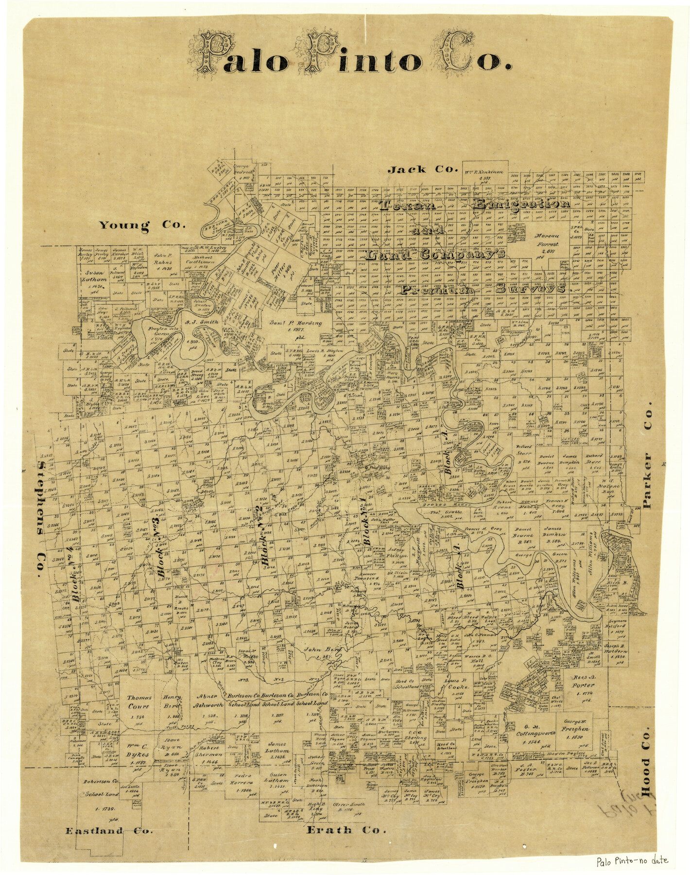
Palo Pinto County
-
Map/Doc
3936
-
Collection
General Map Collection
-
Counties
Palo Pinto
-
Subjects
County
-
Height x Width
23.7 x 18.6 inches
60.2 x 47.2 cm
-
Medium
paper, etching/engraving/lithograph
-
Features
[Fort] Griffin Road
Lone Creek
Palo Pinto & Griffin Road
Buck Creek
Bartons Creek
South Prong [of Palo Pinto Creek]
North Prong of Palo Pinto Creek
Walnut Creek
Boles Creek
Sunday Creek
Warser Creek
Palo Pinto Creek
Ioni Creek
Rock Creek
Palo Pinto Road
West Fork of Eagle Creek
Eagle Creek
Stephensville Road
Palo Pinto
Brazos River
Caddo Creek
Turkey Creek
Keechi Creek
Cedar Bluff Creek
East Fork [of Keechi Creek]
Part of: General Map Collection
Hansford County

Print $20.00
- Digital $50.00
Hansford County
1932
Size 41.8 x 39.8 inches
Map/Doc 1847
Terrell County Working Sketch 29

Print $20.00
- Digital $50.00
Terrell County Working Sketch 29
1944
Size 28.6 x 35.5 inches
Map/Doc 62121
Map of a part of Fisher and Miller's Colony - Harvey's District

Print $20.00
- Digital $50.00
Map of a part of Fisher and Miller's Colony - Harvey's District
1856
Size 19.0 x 24.7 inches
Map/Doc 4657
Flight Mission No. DCL-6C, Frame 14, Kenedy County

Print $20.00
- Digital $50.00
Flight Mission No. DCL-6C, Frame 14, Kenedy County
1943
Size 18.7 x 22.4 inches
Map/Doc 85871
Jeff Davis County Sketch File 32

Print $20.00
- Digital $50.00
Jeff Davis County Sketch File 32
Size 23.8 x 18.8 inches
Map/Doc 11865
Hood County Sketch File 23

Print $20.00
- Digital $50.00
Hood County Sketch File 23
Size 24.5 x 18.6 inches
Map/Doc 11780
Hall County Working Sketch 7

Print $20.00
- Digital $50.00
Hall County Working Sketch 7
1955
Size 31.6 x 18.2 inches
Map/Doc 63335
Brown County Rolled Sketch 2B

Print $20.00
- Digital $50.00
Brown County Rolled Sketch 2B
1984
Size 24.3 x 18.6 inches
Map/Doc 5351
Cameron County Sketch File 15

Print $26.00
- Digital $50.00
Cameron County Sketch File 15
1999
Size 11.2 x 8.7 inches
Map/Doc 17320
Real County Working Sketch 57

Print $20.00
- Digital $50.00
Real County Working Sketch 57
1962
Size 19.6 x 25.8 inches
Map/Doc 71949
Borden County Sketch File 11

Print $4.00
- Digital $50.00
Borden County Sketch File 11
1892
Size 11.0 x 8.9 inches
Map/Doc 14730
Jackson County Working Sketch 7

Print $20.00
- Digital $50.00
Jackson County Working Sketch 7
1973
Size 35.7 x 27.1 inches
Map/Doc 66455
You may also like
Liberty County Sketch File 6

Print $6.00
- Digital $50.00
Liberty County Sketch File 6
1856
Size 12.1 x 7.7 inches
Map/Doc 29893
Deaf Smith Co.

Print $20.00
- Digital $50.00
Deaf Smith Co.
1910
Size 20.2 x 28.1 inches
Map/Doc 1767
Ector County Working Sketch 18

Print $20.00
- Digital $50.00
Ector County Working Sketch 18
1957
Size 42.0 x 39.1 inches
Map/Doc 68861
San Patricio County NRC Article 33.136 Sketch 1

Print $32.00
- Digital $50.00
San Patricio County NRC Article 33.136 Sketch 1
2001
Size 18.5 x 24.1 inches
Map/Doc 61623
Northwest Part of Webb County

Print $40.00
- Digital $50.00
Northwest Part of Webb County
1984
Size 43.2 x 52.9 inches
Map/Doc 95669
Moore County Sketch File X

Print $20.00
- Digital $50.00
Moore County Sketch File X
Size 34.3 x 24.6 inches
Map/Doc 42131
Real County Rolled Sketch 20

Print $20.00
- Digital $50.00
Real County Rolled Sketch 20
2004
Size 24.6 x 35.8 inches
Map/Doc 82573
Edwards County Working Sketch 125

Print $20.00
- Digital $50.00
Edwards County Working Sketch 125
1977
Size 22.3 x 23.5 inches
Map/Doc 69001
The Republic County of Milam. Proposed, Late Fall 1837-December 31, 1838

Print $20.00
The Republic County of Milam. Proposed, Late Fall 1837-December 31, 1838
2020
Size 17.4 x 21.6 inches
Map/Doc 96226

Henderson County Working Sketch 2

Print $20.00
- Digital $50.00
Henderson County Working Sketch 2
Size 29.1 x 30.0 inches
Map/Doc 66135
Morris County Rolled Sketch 2A

Print $20.00
- Digital $50.00
Morris County Rolled Sketch 2A
Size 24.2 x 19.1 inches
Map/Doc 10267