Aransas County Rolled Sketch 28
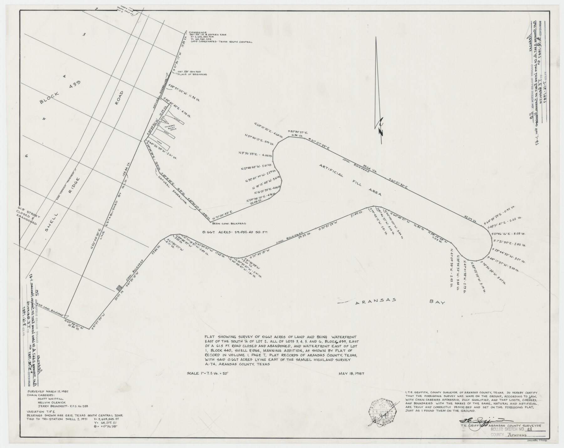
Plat showing survey of 0.667 acres of land and being waterfront east of the south 1/2 of lot 2, all of lots 3, 4, 5, and 6, Block 439, east of a 61.5 ft. road closed and abandoned, and waterfront east of lot 1, Block 440, Shell Ridge, Manning Addition
-
Map/Doc
77496
-
Collection
General Map Collection
-
Object Dates
1987/5/18 (Creation Date)
1987/7/16 (File Date)
1987/3/12 (Survey Date)
-
People and Organizations
T.E. Griffith (Surveyor/Engineer)
Scott Whitfill (Chainman/Field Personnel)
Melvin Olenick (Chainman/Field Personnel)
Jerry Brundrett (Chainman/Field Personnel)
-
Counties
Aransas
-
Subjects
Surveying Rolled Sketch
-
Height x Width
24.5 x 30.9 inches
62.2 x 78.5 cm
-
Medium
mylar, print
Part of: General Map Collection
Schleicher County Sketch File 22

Print $9.00
- Digital $50.00
Schleicher County Sketch File 22
1927
Size 12.8 x 11.7 inches
Map/Doc 36512
Marion County Working Sketch 19

Print $20.00
- Digital $50.00
Marion County Working Sketch 19
1958
Size 29.0 x 23.6 inches
Map/Doc 70795
Starr County Sketch File 32A

Print $26.00
- Digital $50.00
Starr County Sketch File 32A
1938
Size 14.2 x 8.6 inches
Map/Doc 36967
Harris County Rolled Sketch 86

Print $20.00
- Digital $50.00
Harris County Rolled Sketch 86
1933
Size 33.0 x 32.2 inches
Map/Doc 73576
Hidalgo County Working Sketch 5

Print $20.00
- Digital $50.00
Hidalgo County Working Sketch 5
1956
Size 38.1 x 37.9 inches
Map/Doc 66182
University Land in Hudspeth County showing Mineral Surveys in Blocks A, B, C, D, E, F, G, H, I, J, K, L, M, N

Print $40.00
- Digital $50.00
University Land in Hudspeth County showing Mineral Surveys in Blocks A, B, C, D, E, F, G, H, I, J, K, L, M, N
Size 39.7 x 48.4 inches
Map/Doc 2421
King County Boundary File 5b

Print $25.00
- Digital $50.00
King County Boundary File 5b
Size 8.7 x 6.9 inches
Map/Doc 64924
Nueces County Rolled Sketch 114

Print $20.00
- Digital $50.00
Nueces County Rolled Sketch 114
1992
Size 18.1 x 24.6 inches
Map/Doc 7125

Dawson County Rolled Sketch 9

Print $20.00
- Digital $50.00
Dawson County Rolled Sketch 9
1953
Size 36.6 x 45.7 inches
Map/Doc 8773
El Paso County Rolled Sketch 43B

Print $20.00
- Digital $50.00
El Paso County Rolled Sketch 43B
Size 22.0 x 22.0 inches
Map/Doc 5830
Calhoun County Working Sketch 2a

Print $20.00
- Digital $50.00
Calhoun County Working Sketch 2a
1913
Size 17.4 x 20.1 inches
Map/Doc 67817
You may also like
Hemphill County Sketch File 6

Print $8.00
- Digital $50.00
Hemphill County Sketch File 6
1902
Size 14.2 x 8.6 inches
Map/Doc 26299
[Sketch showing Blocks M-20 and M-22]
![91722, [Sketch showing Blocks M-20 and M-22], Twichell Survey Records](https://historictexasmaps.com/wmedia_w700/maps/91722-1.tif.jpg)
Print $20.00
- Digital $50.00
[Sketch showing Blocks M-20 and M-22]
Size 15.0 x 19.5 inches
Map/Doc 91722
[Capitol Leagues in Southwest Hartley and Northwest Oldham Counties]
![90727, [Capitol Leagues in Southwest Hartley and Northwest Oldham Counties], Twichell Survey Records](https://historictexasmaps.com/wmedia_w700/maps/90727-1.tif.jpg)
Print $20.00
- Digital $50.00
[Capitol Leagues in Southwest Hartley and Northwest Oldham Counties]
Size 14.6 x 20.4 inches
Map/Doc 90727
[Texas & Pacific Railway through Callahan County]
![64236, [Texas & Pacific Railway through Callahan County], General Map Collection](https://historictexasmaps.com/wmedia_w700/maps/64236.tif.jpg)
Print $20.00
- Digital $50.00
[Texas & Pacific Railway through Callahan County]
1918
Size 22.9 x 8.8 inches
Map/Doc 64236
M. C. Lindsey's Subdivision of Block 20 College Addition to Lamesa, Texas

Print $20.00
- Digital $50.00
M. C. Lindsey's Subdivision of Block 20 College Addition to Lamesa, Texas
1953
Size 9.6 x 18.2 inches
Map/Doc 92589
San Jacinto County Working Sketch 34

Print $20.00
- Digital $50.00
San Jacinto County Working Sketch 34
1955
Size 25.2 x 25.2 inches
Map/Doc 63747
Burnet County Rolled Sketch 9

Print $40.00
- Digital $50.00
Burnet County Rolled Sketch 9
1971
Size 37.7 x 51.3 inches
Map/Doc 8545
Jasper County Working Sketch 14

Print $40.00
- Digital $50.00
Jasper County Working Sketch 14
1920
Size 37.9 x 55.1 inches
Map/Doc 66476
Childress County Sketch File 18a

Print $4.00
- Digital $50.00
Childress County Sketch File 18a
1935
Size 11.3 x 7.1 inches
Map/Doc 18364
Pecos County Working Sketch 105

Print $40.00
- Digital $50.00
Pecos County Working Sketch 105
1971
Size 49.3 x 43.5 inches
Map/Doc 71578
Crane County Sketch File 26

Print $10.00
- Digital $50.00
Crane County Sketch File 26
1939
Size 11.5 x 9.0 inches
Map/Doc 19598
Dumas, Moore County, Texas

Print $20.00
- Digital $50.00
Dumas, Moore County, Texas
1891
Size 13.4 x 15.7 inches
Map/Doc 92111