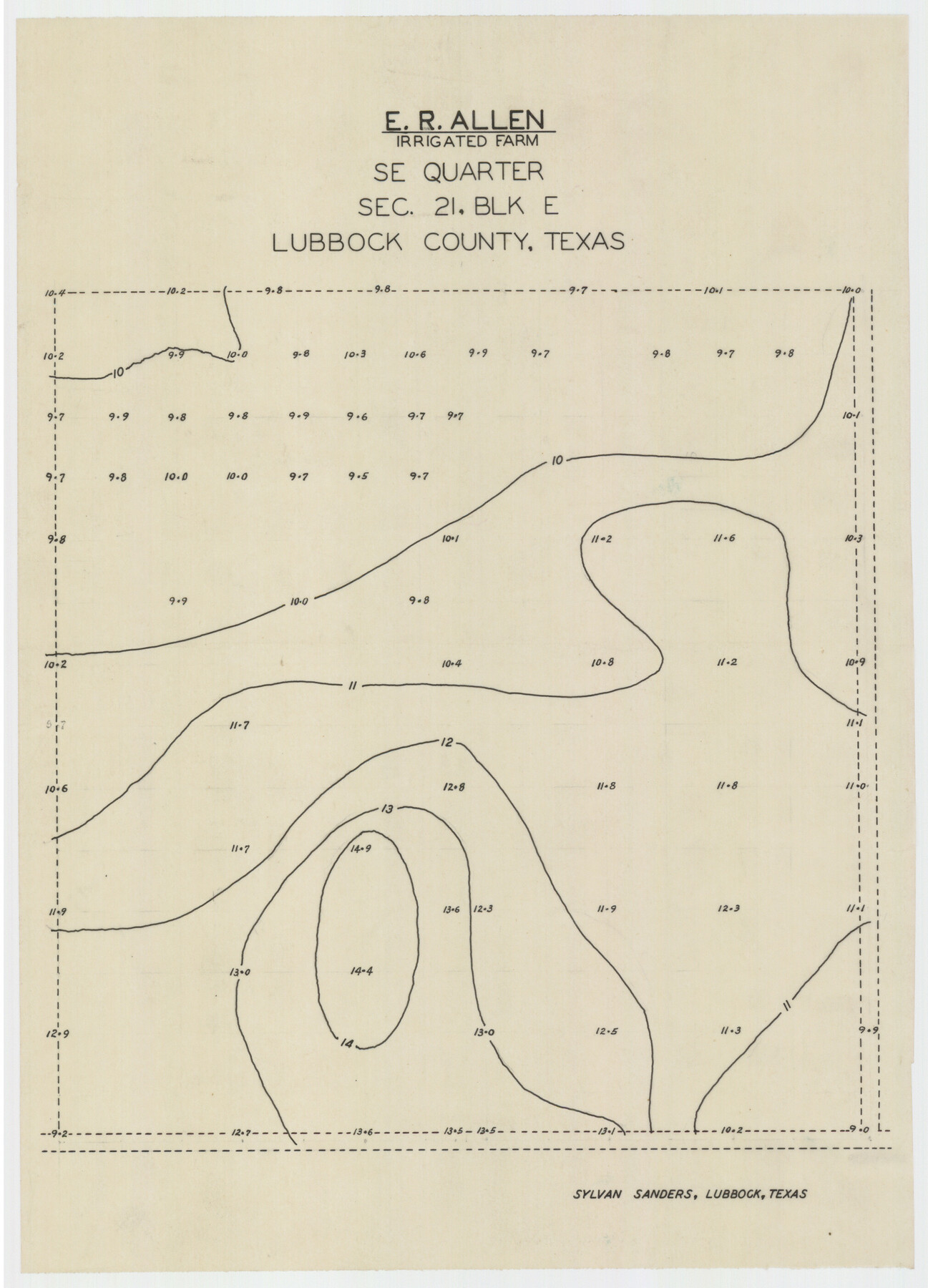
E. R. Allen Irrigated Farm SE Quarter Section 21, Block E
-
Map/Doc
92319
-
Collection
Twichell Survey Records
-
People and Organizations
Sylvan Sanders (Surveyor/Engineer)
-
Counties
Lubbock
-
Height x Width
10.3 x 14.3 inches
26.2 x 36.3 cm
Part of: Twichell Survey Records
[E. T. Ry. Blk. 1]
![89797, [E. T. Ry. Blk. 1], Twichell Survey Records](https://historictexasmaps.com/wmedia_w700/maps/89797-1.tif.jpg)
Print $40.00
- Digital $50.00
[E. T. Ry. Blk. 1]
Size 41.8 x 49.9 inches
Map/Doc 89797
Canyon City,Texas, County Seat of Randall County

Print $20.00
- Digital $50.00
Canyon City,Texas, County Seat of Randall County
Size 20.3 x 25.1 inches
Map/Doc 92152
[Rease Price and Surrounding Surveys]
![91228, [Rease Price and Surrounding Surveys], Twichell Survey Records](https://historictexasmaps.com/wmedia_w700/maps/91228-1.tif.jpg)
Print $20.00
- Digital $50.00
[Rease Price and Surrounding Surveys]
1924
Size 18.7 x 12.7 inches
Map/Doc 91228
[East Portion of Lea County] / [Central part of San Miguel County, New Mexico]
![92033, [East Portion of Lea County] / [Central part of San Miguel County, New Mexico], Twichell Survey Records](https://historictexasmaps.com/wmedia_w700/maps/92033-1.tif.jpg)
Print $20.00
- Digital $50.00
[East Portion of Lea County] / [Central part of San Miguel County, New Mexico]
Size 26.9 x 13.9 inches
Map/Doc 92033
Leagues 35, 36, 37, 38, 39, 40, 41, and 42]
![92236, Leagues 35, 36, 37, 38, 39, 40, 41, and 42], Twichell Survey Records](https://historictexasmaps.com/wmedia_w700/maps/92236-1.tif.jpg)
Print $20.00
- Digital $50.00
Leagues 35, 36, 37, 38, 39, 40, 41, and 42]
Size 40.4 x 34.4 inches
Map/Doc 92236
[Sketch showing Blocks B5, B6 and G.&M. Block 5 north of Capitol Land]
![92990, [Sketch showing Blocks B5, B6 and G.&M. Block 5 north of Capitol Land], Twichell Survey Records](https://historictexasmaps.com/wmedia_w700/maps/92990-1.tif.jpg)
Print $20.00
- Digital $50.00
[Sketch showing Blocks B5, B6 and G.&M. Block 5 north of Capitol Land]
Size 20.7 x 38.2 inches
Map/Doc 92990
Map of Texas-Mexican Railway Lands in El Paso County, Texas

Print $3.00
- Digital $50.00
Map of Texas-Mexican Railway Lands in El Paso County, Texas
1907
Size 13.7 x 10.8 inches
Map/Doc 91134

Borden County

Print $20.00
- Digital $50.00
Borden County
1922
Size 36.8 x 41.7 inches
Map/Doc 92457
Scurry County Sketch Mineral Application No. 42315

Print $20.00
- Digital $50.00
Scurry County Sketch Mineral Application No. 42315
1950
Size 24.0 x 16.5 inches
Map/Doc 92965
Sheet 4 copied from Peck Book 6 [Strip Map showing T. & P. connecting lines]
![93170, Sheet 4 copied from Peck Book 6 [Strip Map showing T. & P. connecting lines], Twichell Survey Records](https://historictexasmaps.com/wmedia_w700/maps/93170-1.tif.jpg)
Print $40.00
- Digital $50.00
Sheet 4 copied from Peck Book 6 [Strip Map showing T. & P. connecting lines]
1909
Size 7.0 x 54.8 inches
Map/Doc 93170

You may also like
Greer County Sketch File 12

Print $20.00
- Digital $50.00
Greer County Sketch File 12
Size 23.6 x 20.1 inches
Map/Doc 11585
Crockett County Sketch File 57

Print $22.00
- Digital $50.00
Crockett County Sketch File 57
Size 12.2 x 8.9 inches
Map/Doc 19832
Orange County Working Sketch 32

Print $20.00
- Digital $50.00
Orange County Working Sketch 32
1956
Size 22.9 x 31.7 inches
Map/Doc 71364
Travis County Sketch File 67

Print $10.00
- Digital $50.00
Travis County Sketch File 67
1951
Size 14.3 x 9.0 inches
Map/Doc 38446
Sutton County Sketch File 26

Print $20.00
- Digital $50.00
Sutton County Sketch File 26
1929
Size 19.6 x 14.8 inches
Map/Doc 12383
Williamson County Rolled Sketch 3

Print $20.00
- Digital $50.00
Williamson County Rolled Sketch 3
1915
Size 40.1 x 30.9 inches
Map/Doc 8261
Culberson County Working Sketch 68

Print $40.00
- Digital $50.00
Culberson County Working Sketch 68
1975
Size 48.9 x 33.5 inches
Map/Doc 68522
Hardin County Working Sketch 12

Print $20.00
- Digital $50.00
Hardin County Working Sketch 12
1934
Size 16.8 x 11.9 inches
Map/Doc 63410
Morris County Working Sketch 4

Print $20.00
- Digital $50.00
Morris County Working Sketch 4
1959
Size 35.2 x 23.8 inches
Map/Doc 71203
Brazos River, Howth Sheet

Print $6.00
- Digital $50.00
Brazos River, Howth Sheet
1936
Size 30.5 x 30.9 inches
Map/Doc 65276
Taylor County Working Sketch 22

Print $40.00
- Digital $50.00
Taylor County Working Sketch 22
1985
Size 50.3 x 37.3 inches
Map/Doc 69632
Edwards County Working Sketch 132

Print $20.00
- Digital $50.00
Edwards County Working Sketch 132
1985
Size 37.1 x 37.1 inches
Map/Doc 69008