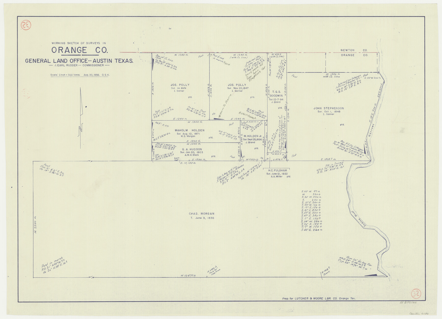
Orange County Working Sketch 32
-
Map/Doc
71364
-
Collection
General Map Collection
-
Object Dates
8/20/1956 (Creation Date)
-
People and Organizations
Otto G. Kurio (Draftsman)
-
Counties
Orange
-
Subjects
Surveying Working Sketch
-
Height x Width
22.9 x 31.7 inches
58.2 x 80.5 cm
-
Scale
1" = 300 varas
Part of: General Map Collection
Sabine County Working Sketch 9

Print $20.00
- Digital $50.00
Sabine County Working Sketch 9
1923
Size 23.9 x 27.1 inches
Map/Doc 63680
Victoria County Rolled Sketch 8

Print $20.00
- Digital $50.00
Victoria County Rolled Sketch 8
Size 34.2 x 27.5 inches
Map/Doc 8153
Flight Mission No. CLL-3N, Frame 38, Willacy County

Print $20.00
- Digital $50.00
Flight Mission No. CLL-3N, Frame 38, Willacy County
1954
Size 18.6 x 22.2 inches
Map/Doc 87096
[Right of Way Map, Belton Branch of the M.K.&T. RR.]
![64225, [Right of Way Map, Belton Branch of the M.K.&T. RR.], General Map Collection](https://historictexasmaps.com/wmedia_w700/maps/64225.tif.jpg)
Print $20.00
- Digital $50.00
[Right of Way Map, Belton Branch of the M.K.&T. RR.]
1896
Size 7.2 x 21.6 inches
Map/Doc 64225
Galveston County NRC Article 33.136 Sketch 79

Print $292.00
- Digital $50.00
Galveston County NRC Article 33.136 Sketch 79
2015
Size 22.0 x 34.0 inches
Map/Doc 94880

Freestone County Working Sketch 7

Print $20.00
- Digital $50.00
Freestone County Working Sketch 7
1951
Size 32.8 x 24.4 inches
Map/Doc 69249
Loving County Sketch File 4

Print $40.00
- Digital $50.00
Loving County Sketch File 4
1961
Size 20.6 x 24.7 inches
Map/Doc 12014
Webb County Working Sketch 50

Print $20.00
- Digital $50.00
Webb County Working Sketch 50
1950
Size 22.9 x 24.9 inches
Map/Doc 72415
Sabine Bank to East Bay including Heald Bank

Print $20.00
- Digital $50.00
Sabine Bank to East Bay including Heald Bank
1976
Size 45.0 x 34.5 inches
Map/Doc 69851
Map of Henderson County

Print $40.00
- Digital $50.00
Map of Henderson County
1897
Size 27.7 x 56.8 inches
Map/Doc 16849
Kimble County Working Sketch 7

Print $20.00
- Digital $50.00
Kimble County Working Sketch 7
1917
Size 12.6 x 16.8 inches
Map/Doc 70075
You may also like
Howard County Sketch File 5

Print $3.00
- Digital $50.00
Howard County Sketch File 5
Size 20.0 x 12.8 inches
Map/Doc 11794
Frio County Working Sketch 20

Print $20.00
- Digital $50.00
Frio County Working Sketch 20
1985
Size 36.3 x 36.0 inches
Map/Doc 69294
Montgomery County Sketch File 32

Print $10.00
- Digital $50.00
Montgomery County Sketch File 32
1933
Size 10.8 x 7.8 inches
Map/Doc 31888
Bailey County Rolled Sketch 7

Print $40.00
- Digital $50.00
Bailey County Rolled Sketch 7
1941
Size 67.7 x 44.8 inches
Map/Doc 8438
[Plat of Trinity River w/ Midstream Profile in Liberty County by US Government 1899]
![65338, [Plat of Trinity River w/ Midstream Profile in Liberty County by US Government 1899], General Map Collection](https://historictexasmaps.com/wmedia_w700/maps/65338.tif.jpg)
Print $20.00
- Digital $50.00
[Plat of Trinity River w/ Midstream Profile in Liberty County by US Government 1899]
1899
Size 12.5 x 16.8 inches
Map/Doc 65338
General Highway Map. Detail of Cities and Towns in Fort Bend County, Texas

Print $20.00
General Highway Map. Detail of Cities and Towns in Fort Bend County, Texas
1961
Size 18.1 x 24.5 inches
Map/Doc 79470
[Sketch of Surveys Near Port Aransas and Aransas Pass, Aransas County, Texas]
![676, [Sketch of Surveys Near Port Aransas and Aransas Pass, Aransas County, Texas], Maddox Collection](https://historictexasmaps.com/wmedia_w700/maps/676.tif.jpg)
Print $20.00
- Digital $50.00
[Sketch of Surveys Near Port Aransas and Aransas Pass, Aransas County, Texas]
Size 22.8 x 18.5 inches
Map/Doc 676
Kenedy County Sketch File 2

Print $130.00
- Digital $50.00
Kenedy County Sketch File 2
1995
Size 11.2 x 8.7 inches
Map/Doc 28773
Angelina County Working Sketch 32b

Print $20.00
- Digital $50.00
Angelina County Working Sketch 32b
1955
Size 23.0 x 28.6 inches
Map/Doc 67115
Floyd County Sketch File 22

Print $4.00
- Digital $50.00
Floyd County Sketch File 22
Size 8.8 x 8.0 inches
Map/Doc 22774
Flight Mission No. BRE-1P, Frame 117, Nueces County

Print $20.00
- Digital $50.00
Flight Mission No. BRE-1P, Frame 117, Nueces County
1956
Size 18.4 x 22.3 inches
Map/Doc 86683
Hopkins County Sketch File 20

Print $4.00
- Digital $50.00
Hopkins County Sketch File 20
1871
Size 12.8 x 8.3 inches
Map/Doc 26725