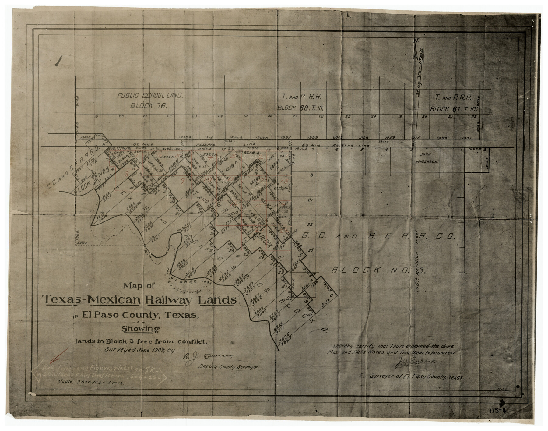
Map of Texas-Mexican Railway Lands in El Paso County, Texas
115-4
-
Map/Doc
91134
-
Collection
Twichell Survey Records
-
Object Dates
6/1907 (Creation Date)
-
People and Organizations
R.J. Owen (Surveyor/Engineer)
-
Counties
Hudspeth
-
Height x Width
13.7 x 10.8 inches
34.8 x 27.4 cm
Part of: Twichell Survey Records
O'Neall Terrace Annex, a Re-Subdivision of the South One-half of Blocks 25 and 31 and all of Blocks 30, 32, and 33 of McCrummen's Second Addition, Lubbock, Texas

Print $20.00
- Digital $50.00
O'Neall Terrace Annex, a Re-Subdivision of the South One-half of Blocks 25 and 31 and all of Blocks 30, 32, and 33 of McCrummen's Second Addition, Lubbock, Texas
1928
Size 23.2 x 27.6 inches
Map/Doc 92747
Blocks 14, 15, and 16, Capitol Syndicate Subdivision of Capitol Land Reservation Leagues

Print $20.00
- Digital $50.00
Blocks 14, 15, and 16, Capitol Syndicate Subdivision of Capitol Land Reservation Leagues
1908
Size 24.6 x 37.1 inches
Map/Doc 90736
Working Sketch in Kaufman County

Print $40.00
- Digital $50.00
Working Sketch in Kaufman County
1922
Size 36.5 x 52.2 inches
Map/Doc 89702
[County lines and corners]
![90801, [County lines and corners], Twichell Survey Records](https://historictexasmaps.com/wmedia_w700/maps/90801-1.tif.jpg)
Print $20.00
- Digital $50.00
[County lines and corners]
Size 22.8 x 17.8 inches
Map/Doc 90801
[Sketch showing A. B. & M. Block 2]
![91701, [Sketch showing A. B. & M. Block 2], Twichell Survey Records](https://historictexasmaps.com/wmedia_w700/maps/91701-1.tif.jpg)
Print $2.00
- Digital $50.00
[Sketch showing A. B. & M. Block 2]
Size 7.5 x 5.8 inches
Map/Doc 91701
Map Showing Present Owners on the Elizabeth Standifer, James Standifer, Jacob Standifer, C. A. West and William Standifer Original Surveys in Bastrop County, Texas

Print $20.00
- Digital $50.00
Map Showing Present Owners on the Elizabeth Standifer, James Standifer, Jacob Standifer, C. A. West and William Standifer Original Surveys in Bastrop County, Texas
1915
Size 22.2 x 31.5 inches
Map/Doc 90152
[Stone, Kyle and Kyle Block M6]
![90414, [Stone, Kyle and Kyle Block M6], Twichell Survey Records](https://historictexasmaps.com/wmedia_w700/maps/90414-1.tif.jpg)
Print $20.00
- Digital $50.00
[Stone, Kyle and Kyle Block M6]
1908
Size 18.6 x 25.5 inches
Map/Doc 90414
[Lgs. 180-183, 196-198, 105-112, 678-680, 699-701, 141-143]
![90160, [Lgs. 180-183, 196-198, 105-112, 678-680, 699-701, 141-143], Twichell Survey Records](https://historictexasmaps.com/wmedia_w700/maps/90160-1.tif.jpg)
Print $20.00
- Digital $50.00
[Lgs. 180-183, 196-198, 105-112, 678-680, 699-701, 141-143]
1913
Size 28.6 x 19.1 inches
Map/Doc 90160
[Blocks 36 and 37, Townships 1S-5S]
![93213, [Blocks 36 and 37, Townships 1S-5S], Twichell Survey Records](https://historictexasmaps.com/wmedia_w700/maps/93213-1.tif.jpg)
Print $40.00
- Digital $50.00
[Blocks 36 and 37, Townships 1S-5S]
Size 28.9 x 83.7 inches
Map/Doc 93213
[Block RG, Block C, San Augustine School Land]
![92863, [Block RG, Block C, San Augustine School Land], Twichell Survey Records](https://historictexasmaps.com/wmedia_w700/maps/92863-1.tif.jpg)
Print $20.00
- Digital $50.00
[Block RG, Block C, San Augustine School Land]
Size 32.8 x 38.7 inches
Map/Doc 92863
[River Sections 54-73, part of Blk. GG]
![90317, [River Sections 54-73, part of Blk. GG], Twichell Survey Records](https://historictexasmaps.com/wmedia_w700/maps/90317-1.tif.jpg)
Print $20.00
- Digital $50.00
[River Sections 54-73, part of Blk. GG]
Size 37.0 x 35.9 inches
Map/Doc 90317
[Hockley, Lubbock, Terry and Lynn Corner]
![92954, [Hockley, Lubbock, Terry and Lynn Corner], Twichell Survey Records](https://historictexasmaps.com/wmedia_w700/maps/92954-1.tif.jpg)
Print $20.00
- Digital $50.00
[Hockley, Lubbock, Terry and Lynn Corner]
Size 24.5 x 18.9 inches
Map/Doc 92954
You may also like
Ector County Working Sketch 32

Print $20.00
- Digital $50.00
Ector County Working Sketch 32
1981
Size 26.2 x 17.0 inches
Map/Doc 68875
The Chief Justice County of Colorado. Undated

Print $20.00
The Chief Justice County of Colorado. Undated
2020
Size 14.8 x 21.6 inches
Map/Doc 96044
Hall County Sketch File 12

Print $20.00
- Digital $50.00
Hall County Sketch File 12
Size 31.9 x 35.5 inches
Map/Doc 10474
Brazos County Rolled Sketch 6

Print $20.00
- Digital $50.00
Brazos County Rolled Sketch 6
1979
Size 24.3 x 36.4 inches
Map/Doc 5190
Dimmit County Sketch File 50

Print $36.00
- Digital $50.00
Dimmit County Sketch File 50
1909
Size 18.2 x 20.4 inches
Map/Doc 21181
Eastland County Sketch File 2

Print $26.00
- Digital $50.00
Eastland County Sketch File 2
Size 8.1 x 7.9 inches
Map/Doc 21559
Travis County Working Sketch Graphic Index - south part

Print $40.00
- Digital $50.00
Travis County Working Sketch Graphic Index - south part
1936
Size 42.6 x 52.8 inches
Map/Doc 76716
Midland County Working Sketch 22

Print $40.00
- Digital $50.00
Midland County Working Sketch 22
1956
Size 97.0 x 43.1 inches
Map/Doc 71003
Concho County Rolled Sketch 16

Print $20.00
- Digital $50.00
Concho County Rolled Sketch 16
1961
Size 24.2 x 15.7 inches
Map/Doc 5551
Harrison County Working Sketch 18

Print $20.00
- Digital $50.00
Harrison County Working Sketch 18
1976
Size 37.0 x 40.1 inches
Map/Doc 66038
Flight Mission No. BQR-9K, Frame 53, Brazoria County

Print $20.00
- Digital $50.00
Flight Mission No. BQR-9K, Frame 53, Brazoria County
1952
Size 18.7 x 22.3 inches
Map/Doc 84057
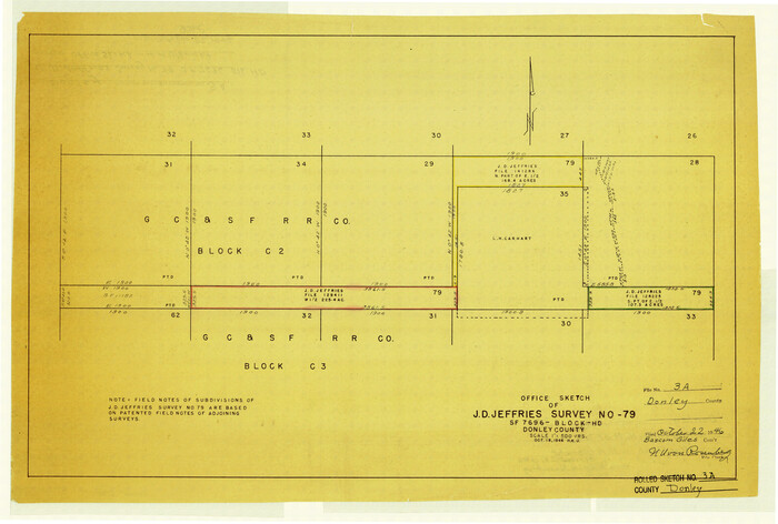
Donley County Rolled Sketch 3A
Print $20.00
- Digital $50.00
Donley County Rolled Sketch 3A
1946
Size 15.2 x 22.6 inches
Map/Doc 5730