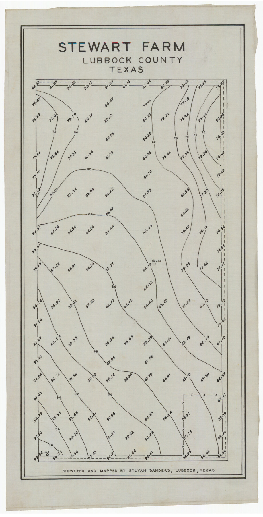
Stewart Farm
-
Map/Doc
92312
-
Collection
Twichell Survey Records
-
People and Organizations
Sylvan Sanders (Surveyor/Engineer)
-
Counties
Lubbock
-
Height x Width
9.8 x 18.6 inches
24.9 x 47.2 cm
Part of: Twichell Survey Records
[Map of North Half of Hutchinson and South Half of Hansford Counties]
![92114, [Map of North Half of Hutchinson and South Half of Hansford Counties], Twichell Survey Records](https://historictexasmaps.com/wmedia_w700/maps/92114-1.tif.jpg)
Print $3.00
- Digital $50.00
[Map of North Half of Hutchinson and South Half of Hansford Counties]
Size 11.6 x 13.5 inches
Map/Doc 92114
D. B. Gardner vs. Mrs. Clara C. Starr

Print $20.00
- Digital $50.00
D. B. Gardner vs. Mrs. Clara C. Starr
Size 16.7 x 28.8 inches
Map/Doc 92149
[Blks. 8, 10, CC 41, and 32]
![90118, [Blks. 8, 10, CC 41, and 32], Twichell Survey Records](https://historictexasmaps.com/wmedia_w700/maps/90118-1.tif.jpg)
Print $20.00
- Digital $50.00
[Blks. 8, 10, CC 41, and 32]
Size 40.6 x 15.4 inches
Map/Doc 90118
City of Littlefield Lamb County Texas Located on Texas State Capitol League 664

Print $20.00
- Digital $50.00
City of Littlefield Lamb County Texas Located on Texas State Capitol League 664
Size 41.0 x 37.1 inches
Map/Doc 89911
Brazos River Conservation and Reclamation District Official Boundary Line Survey

Print $20.00
- Digital $50.00
Brazos River Conservation and Reclamation District Official Boundary Line Survey
Size 36.6 x 24.6 inches
Map/Doc 90128
[Blocks WJG2, FR, 330]
![92330, [Blocks WJG2, FR, 330], Twichell Survey Records](https://historictexasmaps.com/wmedia_w700/maps/92330-1.tif.jpg)
Print $20.00
- Digital $50.00
[Blocks WJG2, FR, 330]
Size 25.8 x 25.8 inches
Map/Doc 92330
Sur. Sketch S. F. 6855

Print $20.00
- Digital $50.00
Sur. Sketch S. F. 6855
Size 20.2 x 10.2 inches
Map/Doc 90788
[SE Pt. of Stephens County]
![89639, [SE Pt. of Stephens County], Twichell Survey Records](https://historictexasmaps.com/wmedia_w700/maps/89639-1.tif.jpg)
Print $20.00
- Digital $50.00
[SE Pt. of Stephens County]
Size 38.1 x 35.9 inches
Map/Doc 89639
[Map of Resurvey of Block 34 and 35, Township 5 N]
![90551, [Map of Resurvey of Block 34 and 35, Township 5 N], Twichell Survey Records](https://historictexasmaps.com/wmedia_w700/maps/90551-1.tif.jpg)
Print $20.00
- Digital $50.00
[Map of Resurvey of Block 34 and 35, Township 5 N]
1915
Size 25.5 x 16.4 inches
Map/Doc 90551
[Sketch Showing Wm. T. Brewer, John R. Taylor, Wm. F. Butler, Timothy DeVore, L. M. Thorn and adjoining surveys]
![90209, [Sketch Showing Wm. T. Brewer, John R. Taylor, Wm. F. Butler, Timothy DeVore, L. M. Thorn and adjoining surveys], Twichell Survey Records](https://historictexasmaps.com/wmedia_w700/maps/90209-1.tif.jpg)
Print $20.00
- Digital $50.00
[Sketch Showing Wm. T. Brewer, John R. Taylor, Wm. F. Butler, Timothy DeVore, L. M. Thorn and adjoining surveys]
Size 20.2 x 36.6 inches
Map/Doc 90209
The Great Lakes Region of the United States and Canada

The Great Lakes Region of the United States and Canada
1953
Size 42.5 x 28.6 inches
Map/Doc 92396
Tech Memorial Park Street Grading Plan

Print $20.00
- Digital $50.00
Tech Memorial Park Street Grading Plan
1948
Size 17.8 x 15.7 inches
Map/Doc 92272
You may also like
Montgomery County Working Sketch 35

Print $20.00
- Digital $50.00
Montgomery County Working Sketch 35
1953
Size 26.6 x 21.7 inches
Map/Doc 71142
Burnet County Sketch File 29

Print $4.00
- Digital $50.00
Burnet County Sketch File 29
1874
Size 10.1 x 8.1 inches
Map/Doc 16744
Harris County Working Sketch 40

Print $20.00
- Digital $50.00
Harris County Working Sketch 40
1940
Size 42.0 x 41.2 inches
Map/Doc 65932
Randall County Boundary File 2a

Print $14.00
- Digital $50.00
Randall County Boundary File 2a
Size 9.6 x 6.1 inches
Map/Doc 58118
Atlas E, Sketch 29 (E-29)

Print $20.00
- Digital $50.00
Atlas E, Sketch 29 (E-29)
Size 22.4 x 33.2 inches
Map/Doc 78363
Flight Mission No. BRE-3P, Frame 95, Nueces County

Print $20.00
- Digital $50.00
Flight Mission No. BRE-3P, Frame 95, Nueces County
1956
Size 18.4 x 22.3 inches
Map/Doc 86826
Brewster County Rolled Sketch 114

Print $20.00
- Digital $50.00
Brewster County Rolled Sketch 114
1964
Size 12.1 x 18.3 inches
Map/Doc 5285
Gray County Working Sketch 5

Print $20.00
- Digital $50.00
Gray County Working Sketch 5
1959
Size 28.6 x 27.5 inches
Map/Doc 63236
[Sketch of area around Mary Fury and John P. Rohus Surveys]
![91917, [Sketch of area around Mary Fury and John P. Rohus Surveys], Twichell Survey Records](https://historictexasmaps.com/wmedia_w700/maps/91917-1.tif.jpg)
Print $20.00
- Digital $50.00
[Sketch of area around Mary Fury and John P. Rohus Surveys]
Size 19.4 x 19.7 inches
Map/Doc 91917
Callahan County Sketch File 14

Print $40.00
- Digital $50.00
Callahan County Sketch File 14
1938
Size 20.5 x 26.1 inches
Map/Doc 11042
The Republic County of Harris. May 15, 1838

Print $20.00
The Republic County of Harris. May 15, 1838
2020
Size 17.7 x 21.7 inches
Map/Doc 96163
Red River County Working Sketch 73

Print $20.00
- Digital $50.00
Red River County Working Sketch 73
1979
Size 17.0 x 19.2 inches
Map/Doc 72056