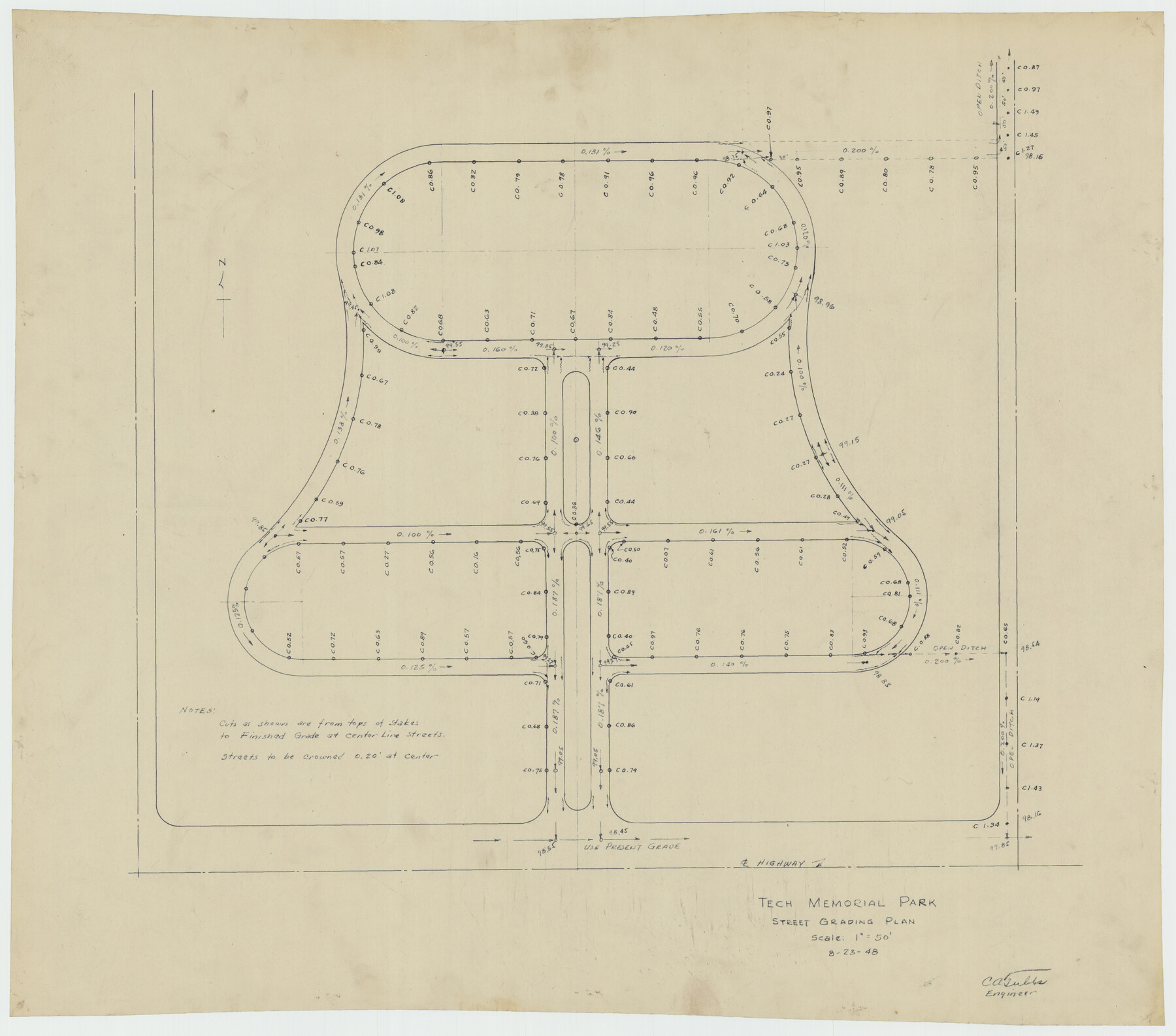
Tech Memorial Park Street Grading Plan
-
Map/Doc
92272
-
Collection
Twichell Survey Records
-
Object Dates
8/23/1948 (Creation Date)
-
People and Organizations
C.A. Tubbs (Surveyor/Engineer)
-
Counties
Lubbock
-
Height x Width
17.8 x 15.7 inches
45.2 x 39.9 cm
Part of: Twichell Survey Records
Working Sketch Fisher County School Land [Leagues 105-108]
![90294, Working Sketch Fisher County School Land [Leagues 105-108], Twichell Survey Records](https://historictexasmaps.com/wmedia_w700/maps/90294-1.tif.jpg)
Print $20.00
- Digital $50.00
Working Sketch Fisher County School Land [Leagues 105-108]
Size 12.9 x 16.7 inches
Map/Doc 90294
R. S. Dod Meanders

Print $20.00
- Digital $50.00
R. S. Dod Meanders
Size 19.0 x 13.2 inches
Map/Doc 91675
Purchase Area Map, Ropesville Rural Communities, Hockley County, Texas

Print $40.00
- Digital $50.00
Purchase Area Map, Ropesville Rural Communities, Hockley County, Texas
1937
Size 52.9 x 29.3 inches
Map/Doc 89681
[In Northwest 1/4 of County in the vicinity of the John Walker Survey]
![90903, [In Northwest 1/4 of County in the vicinity of the John Walker Survey], Twichell Survey Records](https://historictexasmaps.com/wmedia_w700/maps/90903-1.tif.jpg)
Print $2.00
- Digital $50.00
[In Northwest 1/4 of County in the vicinity of the John Walker Survey]
Size 7.3 x 15.3 inches
Map/Doc 90903
[Corner of Crosby, Lubbock, Lynn and Garza Counties]
![90905, [Corner of Crosby, Lubbock, Lynn and Garza Counties], Twichell Survey Records](https://historictexasmaps.com/wmedia_w700/maps/90905-1.tif.jpg)
Print $20.00
- Digital $50.00
[Corner of Crosby, Lubbock, Lynn and Garza Counties]
Size 36.0 x 22.8 inches
Map/Doc 90905
Dallam County

Print $20.00
- Digital $50.00
Dallam County
1888
Size 29.5 x 24.6 inches
Map/Doc 90654
[S.P.R.R.Co. Blocks 15 &16]
![92355, [S.P.R.R.Co. Blocks 15 &16], Twichell Survey Records](https://historictexasmaps.com/wmedia_w700/maps/92355-1.tif.jpg)
Print $20.00
- Digital $50.00
[S.P.R.R.Co. Blocks 15 &16]
Size 37.3 x 32.3 inches
Map/Doc 92355
[PSL A31-A26-A23]
![92451, [PSL A31-A26-A23], Twichell Survey Records](https://historictexasmaps.com/wmedia_w700/maps/92451-1.tif.jpg)
Print $20.00
- Digital $50.00
[PSL A31-A26-A23]
Size 23.7 x 19.3 inches
Map/Doc 92451
H. W. Stanton's Subdivision of Northeast Quarter, Section 15, Block B

Print $20.00
- Digital $50.00
H. W. Stanton's Subdivision of Northeast Quarter, Section 15, Block B
Size 25.3 x 15.8 inches
Map/Doc 92788
[Surveys along Red River in Hartley County]
![90739, [Surveys along Red River in Hartley County], Twichell Survey Records](https://historictexasmaps.com/wmedia_w700/maps/90739-1.tif.jpg)
Print $20.00
- Digital $50.00
[Surveys along Red River in Hartley County]
Size 22.0 x 16.7 inches
Map/Doc 90739
St Francis situated in Potter and Carson Counties, Texas

Print $20.00
- Digital $50.00
St Francis situated in Potter and Carson Counties, Texas
Size 22.4 x 27.7 inches
Map/Doc 93082
[E. L. & R. R. RR. Co. Block D7 and G. H. & H. RR. Co. Block A1]
![91860, [E. L. & R. R. RR. Co. Block D7 and G. H. & H. RR. Co. Block A1], Twichell Survey Records](https://historictexasmaps.com/wmedia_w700/maps/91860-1.tif.jpg)
Print $20.00
- Digital $50.00
[E. L. & R. R. RR. Co. Block D7 and G. H. & H. RR. Co. Block A1]
Size 18.7 x 26.7 inches
Map/Doc 91860
You may also like
Dawson County Working Sketch 22

Print $20.00
- Digital $50.00
Dawson County Working Sketch 22
1989
Size 26.2 x 20.5 inches
Map/Doc 68566
[Plan for Fort Waul near Gonzales, Texas]
![88600, [Plan for Fort Waul near Gonzales, Texas], National Archives Digital Map Collection](https://historictexasmaps.com/wmedia_w700/maps/88600.tif.jpg)
Print $20.00
[Plan for Fort Waul near Gonzales, Texas]
1863
Size 12.3 x 20.3 inches
Map/Doc 88600
Wood County Rolled Sketch 5

Print $20.00
- Digital $50.00
Wood County Rolled Sketch 5
1950
Size 36.8 x 40.2 inches
Map/Doc 10161
City of Austin, Texas - Height and Area adopted by City Council

Print $20.00
- Digital $50.00
City of Austin, Texas - Height and Area adopted by City Council
Size 42.5 x 28.6 inches
Map/Doc 95712
Map of Texas compiled from surveys recorded in the Land Office of Texas, and other official surveys

Print $20.00
Map of Texas compiled from surveys recorded in the Land Office of Texas, and other official surveys
1841
Size 25.1 x 20.4 inches
Map/Doc 76253
Flight Mission No. DCL-6C, Frame 94, Kenedy County

Print $20.00
- Digital $50.00
Flight Mission No. DCL-6C, Frame 94, Kenedy County
1943
Size 18.6 x 22.3 inches
Map/Doc 85924
Wharton County Working Sketch 9

Print $3.00
- Digital $50.00
Wharton County Working Sketch 9
1982
Size 12.4 x 10.4 inches
Map/Doc 72473
Travis County Working Sketch Graphic Index - north part

Print $40.00
- Digital $50.00
Travis County Working Sketch Graphic Index - north part
1936
Size 43.0 x 53.2 inches
Map/Doc 76717
Travis County Working Sketch 42

Print $20.00
- Digital $50.00
Travis County Working Sketch 42
1974
Size 32.5 x 35.2 inches
Map/Doc 69426
Polk County Working Sketch 24

Print $20.00
- Digital $50.00
Polk County Working Sketch 24
1957
Size 24.8 x 25.3 inches
Map/Doc 71640
The Espuela Land and Cattle Co. L'd. West Pastures of the Spur Ranch

Print $20.00
- Digital $50.00
The Espuela Land and Cattle Co. L'd. West Pastures of the Spur Ranch
1904
Size 41.2 x 44.3 inches
Map/Doc 89947
Stonewall County Working Sketch 16

Print $20.00
- Digital $50.00
Stonewall County Working Sketch 16
1954
Size 39.2 x 29.7 inches
Map/Doc 62323