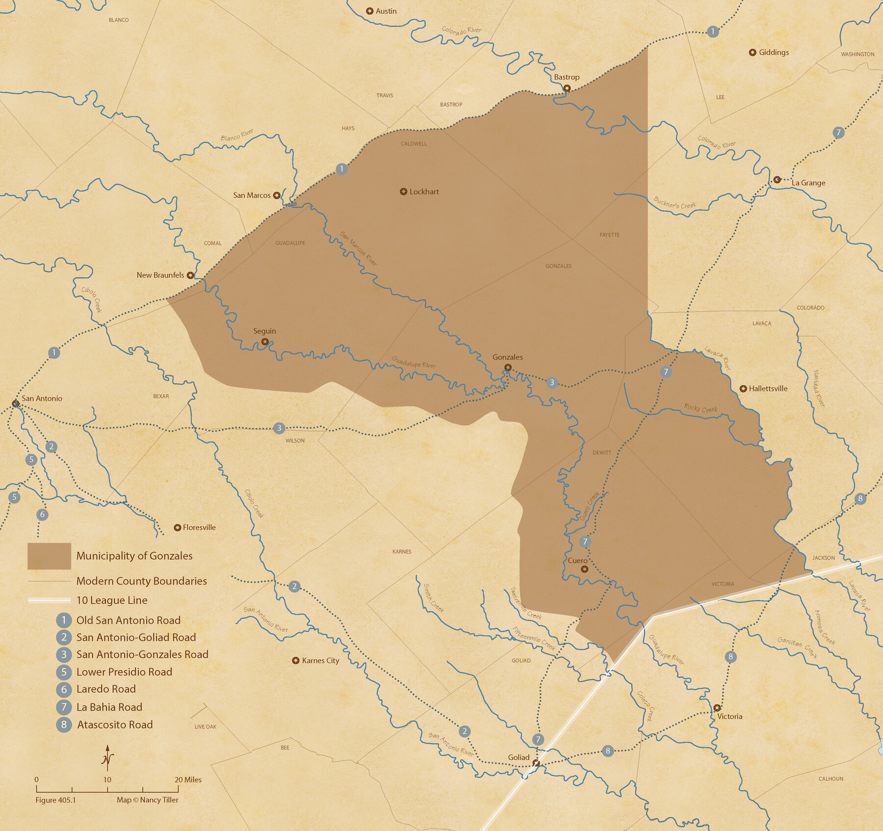
The Mexican Municipality of Gonzales. Proposed, No Date
Figure No. 405.1 from 'A Boundary Atlas of Texas, 1821-1845' by Jim Tiller
- 
                          Map/Doc
96020
 - 
                            Collection
Nancy and Jim Tiller Digital Collection
 - 
                            Object Dates
2020/1/1 (Creation Date)
 - 
                            People and Organizations
Jim Tiller (Author)
Nancy Tiller (Cartographer)
Gang Gong (GIS Professional)
 - 
                            Subjects
Atlas Mexican Texas Texas Boundaries
 - 
                            Height x Width
20.4 x 21.7 inches
51.8 x 55.1 cm
 - 
                            Medium
digital image
 - 
                            Comments
To purchase a digital PDF copy of "A Boundary Atlas of Texas, 1821-1845" see 96437.
 
Part of: Nancy and Jim Tiller Digital Collection
            The Republic County of Goliad. December 31, 1838


                                            Print $20.00                    
                                    
                The Republic County of Goliad. December 31, 1838
2020
Size 15.1 x 21.7 inches
                                Map/Doc 96149
            
            The Republic County of Robertson. January 30, 1841


                                            Print $20.00                    
                                    
                The Republic County of Robertson. January 30, 1841
2020
Size 16.9 x 21.7 inches
                                Map/Doc 96261
            
            A Boundary Atlas of Texas, 1821-1845


                                                                    Digital $50.00                                    
                A Boundary Atlas of Texas, 1821-1845
2020
Map/Doc 96437
            
            The Land Offices. No. 7, Milam, December 22, 1836


                                            Print $20.00                    
                                    
                The Land Offices. No. 7, Milam, December 22, 1836
2020
Size 23.9 x 21.7 inches
                                Map/Doc 96420
            
            The Judicial District/County of Menard. Abolished, Spring 1842


                                            Print $20.00                    
                                    
                The Judicial District/County of Menard. Abolished, Spring 1842
2020
Size 22.4 x 21.7 inches
                                Map/Doc 96337
            
            From Citizens of Nacogdoches County Living East of the Trinity River and Along the Old San Antonio Road for the Creation of a New County (Unnamed), April 22, 1837


                                            Print $20.00                    
                                    
                From Citizens of Nacogdoches County Living East of the Trinity River and Along the Old San Antonio Road for the Creation of a New County (Unnamed), April 22, 1837
2020
Size 19.9 x 21.7 inches
                                Map/Doc 96374
            
            The Republic County of Fort Bend. January 28, 1841


                                            Print $20.00                    
                                    
                The Republic County of Fort Bend. January 28, 1841
2020
Size 14.7 x 21.6 inches
                                Map/Doc 96140
            
            The Chief Justice County of Nacogdoches. Lands in Conflict with Red River and Washington Counties


                                            Print $20.00                    
                                    
                The Chief Justice County of Nacogdoches. Lands in Conflict with Red River and Washington Counties
2020
Size 17.6 x 21.7 inches
                                Map/Doc 96064
            
            The Republic County of Washington. December 29, 1845


                                            Print $20.00                    
                                    
                The Republic County of Washington. December 29, 1845
2020
Size 11.8 x 21.7 inches
                                Map/Doc 96310
            
            The Republic County of Brazos. Created, January 30, 1841


                                            Print $20.00                    
                                    
                The Republic County of Brazos. Created, January 30, 1841
2020
Size 20.6 x 21.7 inches
                                Map/Doc 96116
            
            The Republic County of Harrison. January 30, 1841


                                            Print $20.00                    
                                    
                The Republic County of Harrison. January 30, 1841
2020
Size 18.8 x 21.7 inches
                                Map/Doc 96170
            
            The Republic County of Brazoria. January 1, 1838


                                            Print $20.00                    
                                    
                The Republic County of Brazoria. January 1, 1838
2020
Size 14.7 x 21.8 inches
                                Map/Doc 96111
            You may also like
            Reeves County Rolled Sketch 24


                                            Print $20.00                    
                                             -                         Digital $50.00                                    
                Reeves County Rolled Sketch 24
1982
Size 37.2 x 24.9 inches
                                Map/Doc 7493
            
            Maps & Lists Showing Prison Lands (Oil & Gas) Leased as of June 1955


                                                                    Digital $50.00                                    
                Maps & Lists Showing Prison Lands (Oil & Gas) Leased as of June 1955
Size 11.4 x 7.0 inches
                                Map/Doc 62864
            
            Val Verde County Working Sketch 7


                                            Print $20.00                    
                                             -                         Digital $50.00                                    
                Val Verde County Working Sketch 7
1915
Size 21.9 x 19.5 inches
                                Map/Doc 72142
            
            Coleman County Rolled Sketch 8


                                            Print $40.00                    
                                             -                         Digital $50.00                                    
                Coleman County Rolled Sketch 8
1951
Size 58.8 x 40.8 inches
                                Map/Doc 8634
            
            Chambers County Rolled Sketch 24


                                            Print $40.00                    
                                             -                         Digital $50.00                                    
                Chambers County Rolled Sketch 24
1940
Size 38.2 x 49.9 inches
                                Map/Doc 8594
            
            Castro County Sketch File 1a


                                            Print $8.00                    
                                             -                         Digital $50.00                                    
                Castro County Sketch File 1a
Size 8.6 x 14.0 inches
                                Map/Doc 17454
            
            Flight Mission No. DAH-17M, Frame 27, Orange County


                                            Print $20.00                    
                                             -                         Digital $50.00                                    
                Flight Mission No. DAH-17M, Frame 27, Orange County
1953
Size 18.6 x 22.3 inches
                                Map/Doc 86890
            
            Current Miscellaneous File 61


                                            Print $4.00                    
                                             -                         Digital $50.00                                    
                Current Miscellaneous File 61
1956
Size 9.3 x 13.6 inches
                                Map/Doc 74066
            
            Flight Mission No. DAG-21K, Frame 42, Matagorda County


                                            Print $20.00                    
                                             -                         Digital $50.00                                    
                Flight Mission No. DAG-21K, Frame 42, Matagorda County
1952
Size 18.7 x 22.4 inches
                                Map/Doc 86409
            
            Uvalde County Boundary File 3


                                            Print $28.00                    
                                             -                         Digital $50.00                                    
                Uvalde County Boundary File 3
Size 13.1 x 8.4 inches
                                Map/Doc 59558
            
            [Sketch highlighting Bob Reid and Fred Turner surveys]


                                            Print $20.00                    
                                             -                         Digital $50.00                                    
                [Sketch highlighting Bob Reid and Fred Turner surveys]
Size 12.5 x 17.8 inches
                                Map/Doc 91693
            
            Tom Green County Sketch File 62


                                            Print $20.00                    
                                             -                         Digital $50.00                                    
                Tom Green County Sketch File 62
1890
Size 27.7 x 43.9 inches
                                Map/Doc 10405