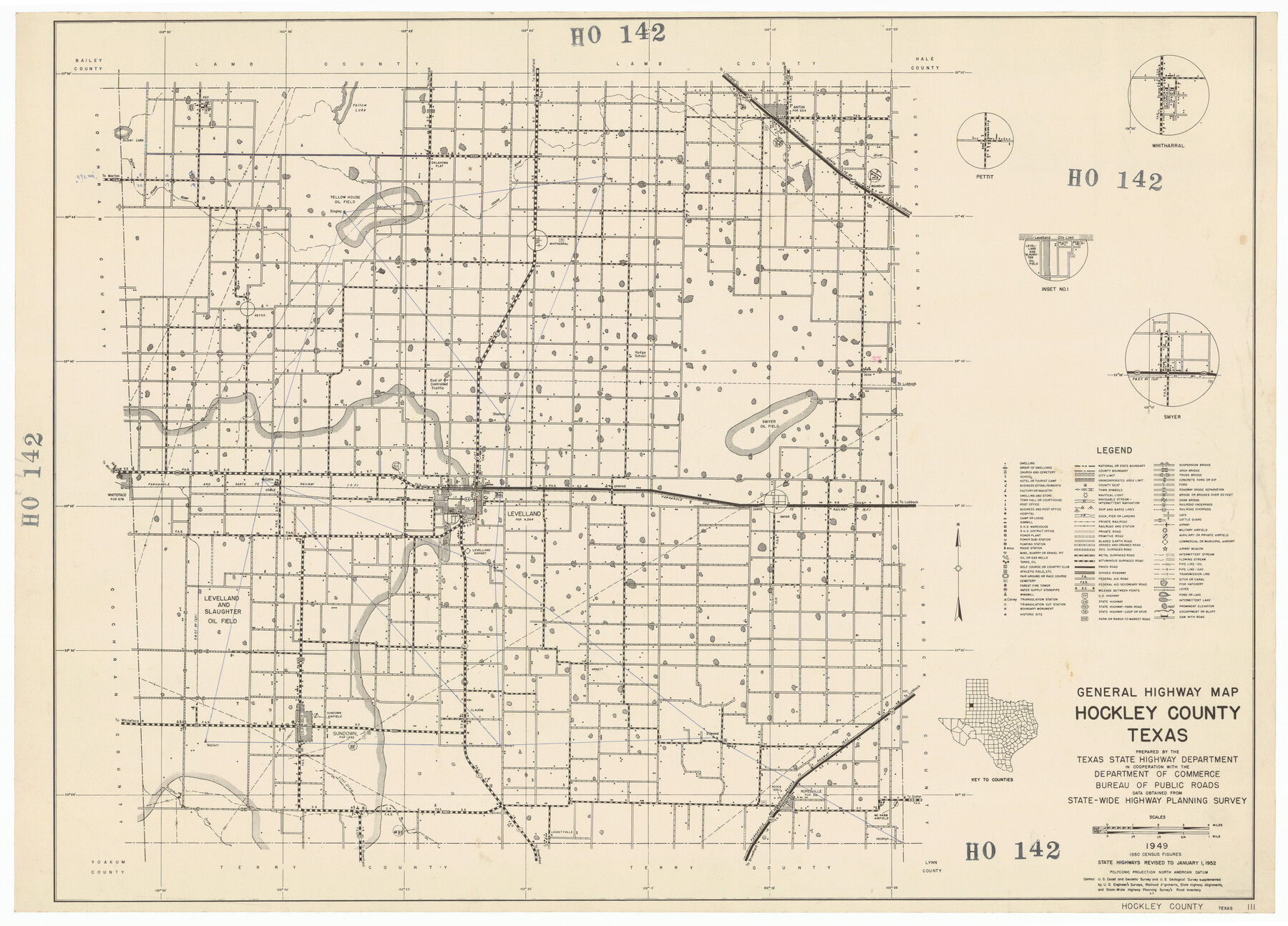
General Highway Map Hockley County, Texas
HO142
-
Map/Doc
92209
-
Collection
Twichell Survey Records
-
Object Dates
1949 (Creation Date)
-
Counties
Hockley
-
Subjects
County
-
Height x Width
25.7 x 18.8 inches
65.3 x 47.8 cm
Part of: Twichell Survey Records
[Blocks T1, T2, and T3]
![90995, [Blocks T1, T2, and T3], Twichell Survey Records](https://historictexasmaps.com/wmedia_w700/maps/90995-1.tif.jpg)
Print $20.00
- Digital $50.00
[Blocks T1, T2, and T3]
1888
Size 16.0 x 25.9 inches
Map/Doc 90995
H. & T. C. Block 47, Sections 1-50; Block E, Sections 1-16; Block G, Sections 1-14

Print $20.00
- Digital $50.00
H. & T. C. Block 47, Sections 1-50; Block E, Sections 1-16; Block G, Sections 1-14
Size 21.5 x 10.3 inches
Map/Doc 91173
Lipscomb County, Texas

Print $20.00
- Digital $50.00
Lipscomb County, Texas
Size 13.7 x 15.0 inches
Map/Doc 91304
Water Distribution Seagraves Located in Surveys 10 & 15, Block C-34

Print $20.00
- Digital $50.00
Water Distribution Seagraves Located in Surveys 10 & 15, Block C-34
Size 22.1 x 15.8 inches
Map/Doc 92899
[Sketch showing H. & G. N. Blk. 1]
![89634, [Sketch showing H. & G. N. Blk. 1], Twichell Survey Records](https://historictexasmaps.com/wmedia_w700/maps/89634-1.tif.jpg)
Print $40.00
- Digital $50.00
[Sketch showing H. & G. N. Blk. 1]
Size 27.1 x 60.6 inches
Map/Doc 89634
Terry County School Land, Gaines County, Texas

Print $20.00
- Digital $50.00
Terry County School Land, Gaines County, Texas
Size 15.6 x 24.7 inches
Map/Doc 92678
Mesa situated in Oldham County, Texas on Survey 90, Block K5

Print $20.00
- Digital $50.00
Mesa situated in Oldham County, Texas on Survey 90, Block K5
1903
Size 15.4 x 14.5 inches
Map/Doc 93010
McLennan County School Land Leagues 3 & 4

Print $20.00
- Digital $50.00
McLennan County School Land Leagues 3 & 4
Size 10.7 x 18.2 inches
Map/Doc 90930
Terry County Memorial Cemetery

Print $20.00
- Digital $50.00
Terry County Memorial Cemetery
Size 35.3 x 14.4 inches
Map/Doc 92931
Bivin's Addition to Amarillo, Texas, Survey 187, Block 2, A. B. & M., Potter County

Print $20.00
- Digital $50.00
Bivin's Addition to Amarillo, Texas, Survey 187, Block 2, A. B. & M., Potter County
Size 20.1 x 23.0 inches
Map/Doc 91739
Plat in Pecos County, Texas

Print $20.00
- Digital $50.00
Plat in Pecos County, Texas
Size 21.4 x 14.9 inches
Map/Doc 91673
League 206, Ochiltree County School Land, Bailey and Lamb Counties, Texas

Print $20.00
- Digital $50.00
League 206, Ochiltree County School Land, Bailey and Lamb Counties, Texas
1954
Size 36.9 x 25.0 inches
Map/Doc 92537
You may also like
Chambers County Sketch File 1

Print $4.00
- Digital $50.00
Chambers County Sketch File 1
1856
Size 7.8 x 12.2 inches
Map/Doc 17516
Map of Glasscock County, Texas

Print $20.00
Map of Glasscock County, Texas
Size 22.7 x 18.3 inches
Map/Doc 88943
Flight Mission No. DAG-28K, Frame 33, Matagorda County

Print $20.00
- Digital $50.00
Flight Mission No. DAG-28K, Frame 33, Matagorda County
1953
Size 16.2 x 16.0 inches
Map/Doc 86601
Texas Coast Country on the Southern Pacific Lines

Texas Coast Country on the Southern Pacific Lines
1917
Size 9.4 x 6.4 inches
Map/Doc 97061
Dickens County Sketch File 22

Print $8.00
- Digital $50.00
Dickens County Sketch File 22
1913
Size 11.2 x 9.1 inches
Map/Doc 20985
Jasper County Working Sketch 35

Print $20.00
- Digital $50.00
Jasper County Working Sketch 35
2008
Size 28.5 x 40.0 inches
Map/Doc 88733
Fort Bend County Sketch File 19

Print $4.00
- Digital $50.00
Fort Bend County Sketch File 19
1890
Size 13.0 x 8.7 inches
Map/Doc 22951
Flight Mission No. DCL-7C, Frame 145, Kenedy County

Print $20.00
- Digital $50.00
Flight Mission No. DCL-7C, Frame 145, Kenedy County
1943
Size 18.6 x 22.5 inches
Map/Doc 86102
Drum, Oyster and Bastrop Bays and Vicinity; Brazoria County, showing Subdivision for Mineral Development

Print $20.00
- Digital $50.00
Drum, Oyster and Bastrop Bays and Vicinity; Brazoria County, showing Subdivision for Mineral Development
1949
Size 35.4 x 45.4 inches
Map/Doc 1908
Flight Mission No. BRA-9M, Frame 80, Jefferson County

Print $20.00
- Digital $50.00
Flight Mission No. BRA-9M, Frame 80, Jefferson County
1953
Size 18.6 x 22.5 inches
Map/Doc 85663
Galveston County NRC Article 33.136 Sketch 99

Print $26.00
Galveston County NRC Article 33.136 Sketch 99
2024
Map/Doc 97422
Flight Mission No. DAG-18K, Frame 184, Matagorda County

Print $20.00
- Digital $50.00
Flight Mission No. DAG-18K, Frame 184, Matagorda County
1952
Size 18.6 x 22.4 inches
Map/Doc 86376