Galveston County NRC Article 33.136 Sketch 99
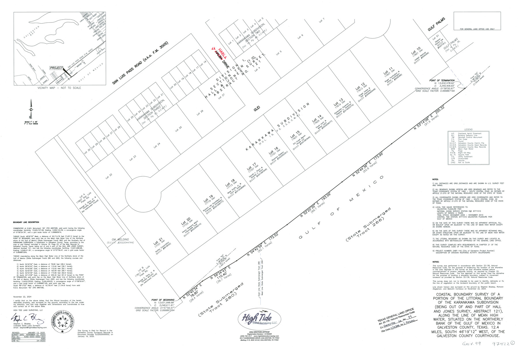
Survey of a portion of the littoral boundary of the Karankawa Subdivision (being out of and part of Hall and Jones Sur., A-121), along the line of mean high water, situated on the northerly bank of the Gulf of Mexico
-
Map/Doc
97422
-
Collection
General Map Collection
-
Object Dates
11/22/2024 (Creation Date)
1/13/2025 (Revision Date)
4/15/2025 (File Date)
-
People and Organizations
Stephen C. Blaskey (Surveyor/Engineer)
-
Counties
Galveston
-
Subjects
Surveying CBS
-
Comments
Project: Karankawa Subdivision Submerged Tract 280, 266, Galveston Co.
This survey is in connection with City of Galveston Project Number 24BF-142, bulkheading for erosion response.
A copy of the survey has been filed under Instrument No. SLS2025000002, Galveston County Surveyors Records.
Part of: General Map Collection
Harrison County Working Sketch 30

Print $20.00
- Digital $50.00
Harrison County Working Sketch 30
2001
Size 29.5 x 31.9 inches
Map/Doc 66050
Flight Mission No. BRE-2P, Frame 73, Nueces County

Print $20.00
- Digital $50.00
Flight Mission No. BRE-2P, Frame 73, Nueces County
1956
Size 18.5 x 22.5 inches
Map/Doc 86768
Red River County Working Sketch 4

Print $20.00
- Digital $50.00
Red River County Working Sketch 4
1919
Size 19.7 x 18.8 inches
Map/Doc 71987
Carte Générale des États-Unis pour servir a l'Histoire de la Louisiane

Print $20.00
- Digital $50.00
Carte Générale des États-Unis pour servir a l'Histoire de la Louisiane
1829
Size 12.0 x 15.9 inches
Map/Doc 97260
Foard County Working Sketch 13

Print $40.00
- Digital $50.00
Foard County Working Sketch 13
1981
Size 44.0 x 51.2 inches
Map/Doc 69204
Limestone County

Print $40.00
- Digital $50.00
Limestone County
1922
Size 50.6 x 36.2 inches
Map/Doc 73342
Outer Continental Shelf Leasing Maps (Texas Offshore Operations)

Print $20.00
- Digital $50.00
Outer Continental Shelf Leasing Maps (Texas Offshore Operations)
Size 12.7 x 15.2 inches
Map/Doc 76169
Colorado County Sketch File 18

Print $40.00
- Digital $50.00
Colorado County Sketch File 18
1897
Size 12.5 x 15.8 inches
Map/Doc 18950
Map of the Columbia and Wharton Division of the Galveston & Eagle Pass Airline Railway

Print $20.00
- Digital $50.00
Map of the Columbia and Wharton Division of the Galveston & Eagle Pass Airline Railway
1881
Size 30.3 x 17.3 inches
Map/Doc 64483
Motley County Sketch File 22 (N)

Print $34.00
- Digital $50.00
Motley County Sketch File 22 (N)
1887
Size 8.2 x 8.4 inches
Map/Doc 32069
Duval County Sketch File 5

Print $20.00
- Digital $50.00
Duval County Sketch File 5
1860
Size 20.8 x 29.6 inches
Map/Doc 11381
Val Verde County Sketch File 22

Print $20.00
- Digital $50.00
Val Verde County Sketch File 22
Size 14.3 x 22.3 inches
Map/Doc 12571
You may also like
Starr County Sketch File 13

Print $20.00
- Digital $50.00
Starr County Sketch File 13
1886
Size 12.4 x 19.5 inches
Map/Doc 12329
Henderson County Sketch File 9

Print $8.00
- Digital $50.00
Henderson County Sketch File 9
Size 8.3 x 7.8 inches
Map/Doc 26343
Castro County, Texas

Print $20.00
- Digital $50.00
Castro County, Texas
1883
Size 20.8 x 18.7 inches
Map/Doc 682
Hardin County Working Sketch 6

Print $20.00
- Digital $50.00
Hardin County Working Sketch 6
1922
Size 16.2 x 28.4 inches
Map/Doc 63404
Guadalupe County Sketch File 26

Print $4.00
- Digital $50.00
Guadalupe County Sketch File 26
1873
Size 10.2 x 8.2 inches
Map/Doc 24719
Stonewall County Boundary File 4b

Print $18.00
- Digital $50.00
Stonewall County Boundary File 4b
Size 9.1 x 8.8 inches
Map/Doc 58993
Hudspeth County Working Sketch 23

Print $40.00
- Digital $50.00
Hudspeth County Working Sketch 23
1967
Size 52.6 x 39.2 inches
Map/Doc 66305
Coke County Rolled Sketch 21

Print $20.00
- Digital $50.00
Coke County Rolled Sketch 21
1954
Size 14.0 x 24.4 inches
Map/Doc 5522
Shelby County Sketch File 21

Print $2.00
- Digital $50.00
Shelby County Sketch File 21
Size 8.9 x 4.0 inches
Map/Doc 36642
Liberty County Sketch File M

Print $20.00
- Digital $50.00
Liberty County Sketch File M
1879
Size 16.9 x 14.5 inches
Map/Doc 12000
Orange County Sketch File 40

Print $20.00
- Digital $50.00
Orange County Sketch File 40
1895
Size 18.2 x 22.7 inches
Map/Doc 12128
Brewster County Rolled Sketch 57

Print $20.00
- Digital $50.00
Brewster County Rolled Sketch 57
1937
Size 43.1 x 37.8 inches
Map/Doc 8482