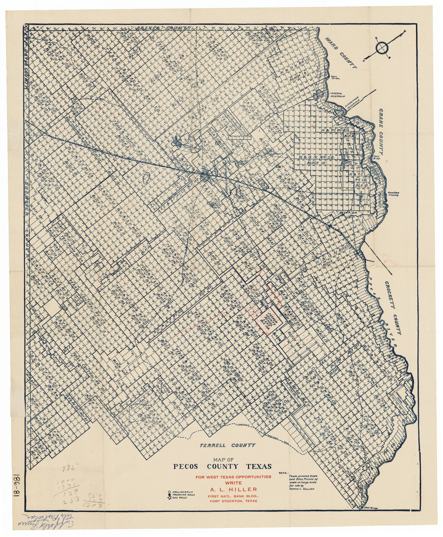
Map of Pecos County, Texas
186-81
-
Map/Doc
91573
-
Collection
Twichell Survey Records
-
Counties
Pecos
-
Subjects
County
-
Height x Width
18.9 x 22.8 inches
48.0 x 57.9 cm
Part of: Twichell Survey Records
![89829, [Central Yates], Twichell Survey Records](https://historictexasmaps.com/wmedia_w700/maps/89829-1.tif.jpg)
T. C. Ivey Ranch, Block D, Yoakum Co., Texas

Print $20.00
- Digital $50.00
T. C. Ivey Ranch, Block D, Yoakum Co., Texas
Size 17.1 x 14.6 inches
Map/Doc 91976

[C. C. Slaughter Block 1, T. T. RR. Co. Block 2]
![90621, [C. C. Slaughter Block 1, T. T. RR. Co. Block 2], Twichell Survey Records](https://historictexasmaps.com/wmedia_w700/maps/90621-1.tif.jpg)
Print $2.00
- Digital $50.00
[C. C. Slaughter Block 1, T. T. RR. Co. Block 2]
Size 8.6 x 11.5 inches
Map/Doc 90621
[Block 103 H. & G. N., Blocks 140 and 141]
![91676, [Block 103 H. & G. N., Blocks 140 and 141], Twichell Survey Records](https://historictexasmaps.com/wmedia_w700/maps/91676-1.tif.jpg)
Print $20.00
- Digital $50.00
[Block 103 H. & G. N., Blocks 140 and 141]
Size 16.3 x 16.0 inches
Map/Doc 91676
Working Sketch in Eastland Co.

Print $20.00
- Digital $50.00
Working Sketch in Eastland Co.
1918
Size 12.2 x 17.1 inches
Map/Doc 90881
Plat Showing the Construction of Texas & Pacific Ry. Co. Blocks 3 & 4 As Located by G. A. Lider

Print $40.00
- Digital $50.00
Plat Showing the Construction of Texas & Pacific Ry. Co. Blocks 3 & 4 As Located by G. A. Lider
1913
Size 51.4 x 36.3 inches
Map/Doc 89931
Working Sketch in Randall and Swisher Cos.

Print $2.00
- Digital $50.00
Working Sketch in Randall and Swisher Cos.
Size 5.8 x 4.1 inches
Map/Doc 93047
Preliminary Re-Plat of Lots 13-20, 45-52, 77-84, and 97-104 James Subdivision

Print $20.00
- Digital $50.00
Preliminary Re-Plat of Lots 13-20, 45-52, 77-84, and 97-104 James Subdivision
1953
Size 11.8 x 36.7 inches
Map/Doc 93222
[Blocks B12 and 6T]
![91512, [Blocks B12 and 6T], Twichell Survey Records](https://historictexasmaps.com/wmedia_w700/maps/91512-1.tif.jpg)
Print $2.00
- Digital $50.00
[Blocks B12 and 6T]
Size 14.6 x 8.9 inches
Map/Doc 91512
Map of Terry County

Print $20.00
- Digital $50.00
Map of Terry County
1917
Size 17.7 x 22.6 inches
Map/Doc 91874
The T. B. Duggan Subdivision of League 125 and N 3/5 of League 126, Coke County School Lands, Cochran County, Texas

Print $20.00
- Digital $50.00
The T. B. Duggan Subdivision of League 125 and N 3/5 of League 126, Coke County School Lands, Cochran County, Texas
1920
Size 14.9 x 21.5 inches
Map/Doc 90300
You may also like

Bowie County Working Sketch 23

Print $20.00
- Digital $50.00
Bowie County Working Sketch 23
1969
Size 25.5 x 29.7 inches
Map/Doc 67427
Ellis County Sketch File 23

Print $4.00
- Digital $50.00
Ellis County Sketch File 23
1873
Size 10.3 x 8.3 inches
Map/Doc 21881
Hidalgo County Rolled Sketch 16

Print $40.00
- Digital $50.00
Hidalgo County Rolled Sketch 16
1963
Size 68.9 x 42.2 inches
Map/Doc 9171
Harris County Working Sketch 129

Print $20.00
- Digital $50.00
Harris County Working Sketch 129
2014
Size 24.2 x 19.1 inches
Map/Doc 93711
Map of Lampasas County

Print $20.00
- Digital $50.00
Map of Lampasas County
1876
Size 18.7 x 24.4 inches
Map/Doc 3794
The Official Map of the City of El Paso, State of Texas

Print $20.00
The Official Map of the City of El Paso, State of Texas
1889
Size 41.9 x 46.2 inches
Map/Doc 89618
Texas-Oklahoma, Red River, Big Bend Area

Print $40.00
- Digital $50.00
Texas-Oklahoma, Red River, Big Bend Area
1921
Size 23.3 x 57.6 inches
Map/Doc 75251
Zapata County Rolled Sketch 26

Print $20.00
- Digital $50.00
Zapata County Rolled Sketch 26
1982
Size 43.0 x 30.7 inches
Map/Doc 8319
Gaines County Rolled Sketch 14B

Print $40.00
- Digital $50.00
Gaines County Rolled Sketch 14B
1940
Size 142.9 x 24.0 inches
Map/Doc 9032
McCulloch County Sketch File 5

Print $11.00
- Digital $50.00
McCulloch County Sketch File 5
1899
Size 17.5 x 9.2 inches
Map/Doc 31177
Medina County Rolled Sketch 5

Print $40.00
- Digital $50.00
Medina County Rolled Sketch 5
1948
Size 52.0 x 47.1 inches
Map/Doc 9505