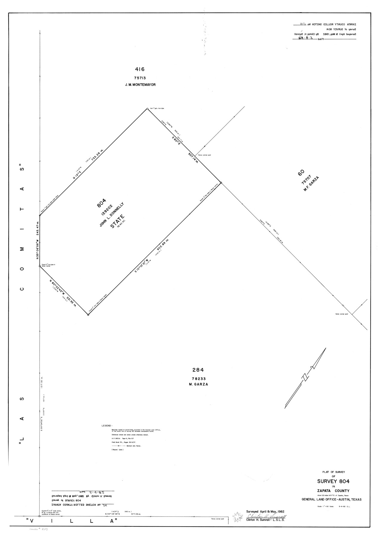
Zapata County Rolled Sketch 26
Plat of survey of survey 804 in Zapata County
-
Map/Doc
8319
-
Collection
General Map Collection
-
Object Dates
1982/5/4 (Creation Date)
1982/5/4 (File Date)
-
People and Organizations
Clinton H. Sumrall (Surveyor/Engineer)
-
Counties
Zapata
-
Subjects
Surveying Rolled Sketch
-
Height x Width
43.0 x 30.7 inches
109.2 x 78.0 cm
-
Medium
mylar, print
-
Scale
1" = 60 varas
Part of: General Map Collection
Baylor County

Print $20.00
- Digital $50.00
Baylor County
1961
Size 43.0 x 35.2 inches
Map/Doc 95426
Coast Chart No. 209 - Aransas Pass, Aransas and Copano Bays, Texas

Print $20.00
- Digital $50.00
Coast Chart No. 209 - Aransas Pass, Aransas and Copano Bays, Texas
1906
Size 40.2 x 33.8 inches
Map/Doc 73430
Freestone County Working Sketch 14

Print $20.00
- Digital $50.00
Freestone County Working Sketch 14
1980
Size 37.4 x 38.9 inches
Map/Doc 69256
Jeff Davis County Boundary File 2

Print $14.00
- Digital $50.00
Jeff Davis County Boundary File 2
Size 14.3 x 8.8 inches
Map/Doc 55505
Fisher County Sketch File 12

Print $22.00
- Digital $50.00
Fisher County Sketch File 12
1893
Size 9.0 x 7.0 inches
Map/Doc 22577
Plat of Resurvey of Sections 5, 7 and 8, T. 5S., R. 14W. Indian Meridian, Oklahoma

Print $4.00
- Digital $50.00
Plat of Resurvey of Sections 5, 7 and 8, T. 5S., R. 14W. Indian Meridian, Oklahoma
1917
Size 18.5 x 22.6 inches
Map/Doc 75140
Val Verde County Sketch File 18

Print $8.00
- Digital $50.00
Val Verde County Sketch File 18
1883
Size 13.1 x 8.4 inches
Map/Doc 39225
Borden County Rolled Sketch 12

Print $40.00
- Digital $50.00
Borden County Rolled Sketch 12
1964
Size 48.1 x 31.6 inches
Map/Doc 8451
Culberson County Working Sketch 17

Print $20.00
- Digital $50.00
Culberson County Working Sketch 17
1927
Size 22.9 x 35.2 inches
Map/Doc 68469
Flight Mission No. BQR-13K, Frame 119, Brazoria County

Print $20.00
- Digital $50.00
Flight Mission No. BQR-13K, Frame 119, Brazoria County
1952
Size 19.0 x 22.6 inches
Map/Doc 84080
Briscoe County Sketch File 2a

Print $4.00
- Digital $50.00
Briscoe County Sketch File 2a
Size 6.2 x 7.1 inches
Map/Doc 16415

You may also like
Rand McNally Standard Map of Texas

Print $20.00
- Digital $50.00
Rand McNally Standard Map of Texas
1926
Size 27.3 x 39.9 inches
Map/Doc 95855
La Salle County Rolled Sketch 18

Print $20.00
- Digital $50.00
La Salle County Rolled Sketch 18
Size 29.8 x 20.6 inches
Map/Doc 6582
Ochiltree County Rolled Sketch 1

Print $20.00
- Digital $50.00
Ochiltree County Rolled Sketch 1
1942
Size 29.3 x 38.8 inches
Map/Doc 9655
Comal County Rolled Sketch 6

Print $4.00
- Digital $50.00
Comal County Rolled Sketch 6
1988
Size 25.0 x 19.1 inches
Map/Doc 5541
Pecos County Working Sketch 111

Print $40.00
- Digital $50.00
Pecos County Working Sketch 111
1972
Size 32.9 x 69.6 inches
Map/Doc 71584
Angelina County, Nacogdoches District

Print $20.00
- Digital $50.00
Angelina County, Nacogdoches District
1882
Size 20.0 x 27.6 inches
Map/Doc 3234
Brazos River, Brazos River Sheet 2

Print $20.00
- Digital $50.00
Brazos River, Brazos River Sheet 2
1926
Size 22.3 x 29.4 inches
Map/Doc 69666
de Leon Empresario Colony. Absorbed by DeWitt Colony. April 15, 1825

Print $20.00
de Leon Empresario Colony. Absorbed by DeWitt Colony. April 15, 1825
2020
Size 18.5 x 21.7 inches
Map/Doc 95989
Victoria County

Print $20.00
- Digital $50.00
Victoria County
1858
Size 26.5 x 29.2 inches
Map/Doc 4115
Van Zandt County Working Sketch 9

Print $20.00
- Digital $50.00
Van Zandt County Working Sketch 9
1982
Size 12.6 x 11.7 inches
Map/Doc 72259
Bee County Working Sketch 20

Print $20.00
- Digital $50.00
Bee County Working Sketch 20
1982
Size 23.6 x 21.3 inches
Map/Doc 67270
Andrews County Rolled Sketch 18

Print $20.00
- Digital $50.00
Andrews County Rolled Sketch 18
1942
Size 26.0 x 31.3 inches
Map/Doc 8394