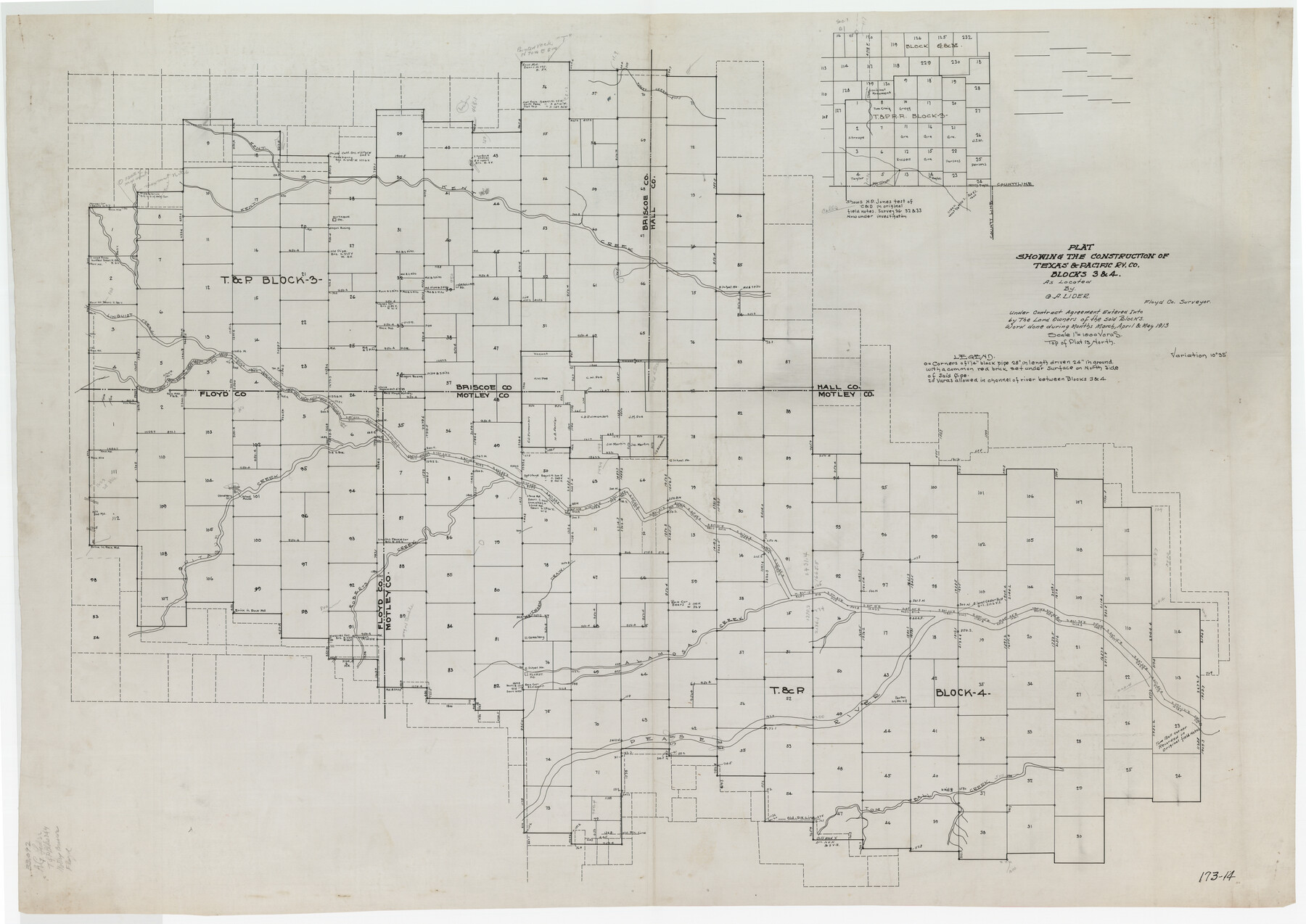
Plat Showing the Construction of Texas & Pacific Ry. Co. Blocks 3 & 4 As Located by G. A. Lider
173-14
-
Map/Doc
89931
-
Collection
Twichell Survey Records
-
Object Dates
5/1913 (Creation Date)
-
Counties
Motley Floyd Briscoe Hall
-
Height x Width
51.4 x 36.3 inches
130.6 x 92.2 cm
Part of: Twichell Survey Records
Map of N. W. Portion Blk G. Gaines Co.

Print $20.00
- Digital $50.00
Map of N. W. Portion Blk G. Gaines Co.
1914
Size 37.4 x 26.7 inches
Map/Doc 90867
Working Sketch Reeves County [showing Blocks 70-72, C-8, 9, 17-18, and Texas & Pacific RR Block 58]
![91770, Working Sketch Reeves County [showing Blocks 70-72, C-8, 9, 17-18, and Texas & Pacific RR Block 58], Twichell Survey Records](https://historictexasmaps.com/wmedia_w700/maps/91770-1.tif.jpg)
Print $20.00
- Digital $50.00
Working Sketch Reeves County [showing Blocks 70-72, C-8, 9, 17-18, and Texas & Pacific RR Block 58]
1908
Size 21.6 x 17.2 inches
Map/Doc 91770
[Sketch showing Blocks B-11, G and M-2 and 3, L, and 47, Sections 77-102]
![91734, [Sketch showing Blocks B-11, G and M-2 and 3, L, and 47, Sections 77-102], Twichell Survey Records](https://historictexasmaps.com/wmedia_w700/maps/91734-1.tif.jpg)
Print $20.00
- Digital $50.00
[Sketch showing Blocks B-11, G and M-2 and 3, L, and 47, Sections 77-102]
Size 25.6 x 18.9 inches
Map/Doc 91734
L Sketch from Ward and Crane Co's

Print $20.00
- Digital $50.00
L Sketch from Ward and Crane Co's
Size 39.6 x 23.2 inches
Map/Doc 90462
Dawson County Sketch [showing T. & P. Blocks 34 and 33, Township 5 N]
![90546, Dawson County Sketch [showing T. & P. Blocks 34 and 33, Township 5 N], Twichell Survey Records](https://historictexasmaps.com/wmedia_w700/maps/90546-1.tif.jpg)
Print $2.00
- Digital $50.00
Dawson County Sketch [showing T. & P. Blocks 34 and 33, Township 5 N]
Size 12.6 x 7.0 inches
Map/Doc 90546

[Sketch of Blks. C-11, C-10, C-8, C-9, C-17 and other in vicinity]
![89793, [Sketch of Blks. C-11, C-10, C-8, C-9, C-17 and other in vicinity], Twichell Survey Records](https://historictexasmaps.com/wmedia_w700/maps/89793-1.tif.jpg)
Print $20.00
- Digital $50.00
[Sketch of Blks. C-11, C-10, C-8, C-9, C-17 and other in vicinity]
Size 43.8 x 39.2 inches
Map/Doc 89793
[Sketch to show the positions of surveys 1-18 made by G. R. Jowell with reference to Capitol Leagues]
![90539, [Sketch to show the positions of surveys 1-18 made by G. R. Jowell with reference to Capitol Leagues], Twichell Survey Records](https://historictexasmaps.com/wmedia_w700/maps/90539-1.tif.jpg)
Print $20.00
- Digital $50.00
[Sketch to show the positions of surveys 1-18 made by G. R. Jowell with reference to Capitol Leagues]
1905
Size 14.7 x 14.6 inches
Map/Doc 90539

Sketch Showing Original Corners and Connections affecting Blocks T1, T2, and T3 in Lamb and Castro Counties, Texas

Print $20.00
- Digital $50.00
Sketch Showing Original Corners and Connections affecting Blocks T1, T2, and T3 in Lamb and Castro Counties, Texas
Size 17.3 x 29.1 inches
Map/Doc 92982
Childress County School Land Situated in Bailey and Cochran Counties

Print $20.00
- Digital $50.00
Childress County School Land Situated in Bailey and Cochran Counties
Size 21.8 x 25.4 inches
Map/Doc 92499
[Sketch showing Midland and Martin County School Land Leagues]
![90295, [Sketch showing Midland and Martin County School Land Leagues], Twichell Survey Records](https://historictexasmaps.com/wmedia_w700/maps/90295-1.tif.jpg)
Print $20.00
- Digital $50.00
[Sketch showing Midland and Martin County School Land Leagues]
Size 14.0 x 18.0 inches
Map/Doc 90295
You may also like
Flight Mission No. BRA-7M, Frame 36, Jefferson County

Print $20.00
- Digital $50.00
Flight Mission No. BRA-7M, Frame 36, Jefferson County
1953
Size 18.7 x 22.3 inches
Map/Doc 85487
Flight Mission No. DQO-8K, Frame 48, Galveston County

Print $20.00
- Digital $50.00
Flight Mission No. DQO-8K, Frame 48, Galveston County
1952
Size 18.7 x 22.2 inches
Map/Doc 85155
Hidalgo County Working Sketch 2

Print $20.00
- Digital $50.00
Hidalgo County Working Sketch 2
1906
Size 22.0 x 28.0 inches
Map/Doc 66179
Motley County Sketch File 9a (N)

Print $4.00
- Digital $50.00
Motley County Sketch File 9a (N)
1885
Size 14.2 x 8.6 inches
Map/Doc 32024
[F. W. & D. C. Ry. Co. Alignment and Right of Way Map, Clay County]
![64737, [F. W. & D. C. Ry. Co. Alignment and Right of Way Map, Clay County], General Map Collection](https://historictexasmaps.com/wmedia_w700/maps/64737-GC.tif.jpg)
Print $20.00
- Digital $50.00
[F. W. & D. C. Ry. Co. Alignment and Right of Way Map, Clay County]
1927
Size 18.6 x 11.8 inches
Map/Doc 64737
Crockett County Working Sketch 39

Print $20.00
- Digital $50.00
Crockett County Working Sketch 39
1928
Size 14.7 x 22.2 inches
Map/Doc 68372
Sketch of Menard Co.

Print $20.00
- Digital $50.00
Sketch of Menard Co.
1883
Size 15.1 x 14.2 inches
Map/Doc 536
Cuadro Geografico y Estadistico

Print $20.00
- Digital $50.00
Cuadro Geografico y Estadistico
Size 23.1 x 30.9 inches
Map/Doc 96982
Webb County Sketch File 4a

Print $8.00
- Digital $50.00
Webb County Sketch File 4a
1877
Size 11.6 x 4.0 inches
Map/Doc 39718
Stonewall County Sketch File 25

Print $7.00
- Digital $50.00
Stonewall County Sketch File 25
1952
Size 26.7 x 43.3 inches
Map/Doc 10375
Young County Working Sketch 7

Print $20.00
- Digital $50.00
Young County Working Sketch 7
1919
Size 24.3 x 19.8 inches
Map/Doc 62030
The Texas and Oklahoma Official Railway & Hotel Guide Map

Print $20.00
- Digital $50.00
The Texas and Oklahoma Official Railway & Hotel Guide Map
1906
Size 23.4 x 23.7 inches
Map/Doc 95892