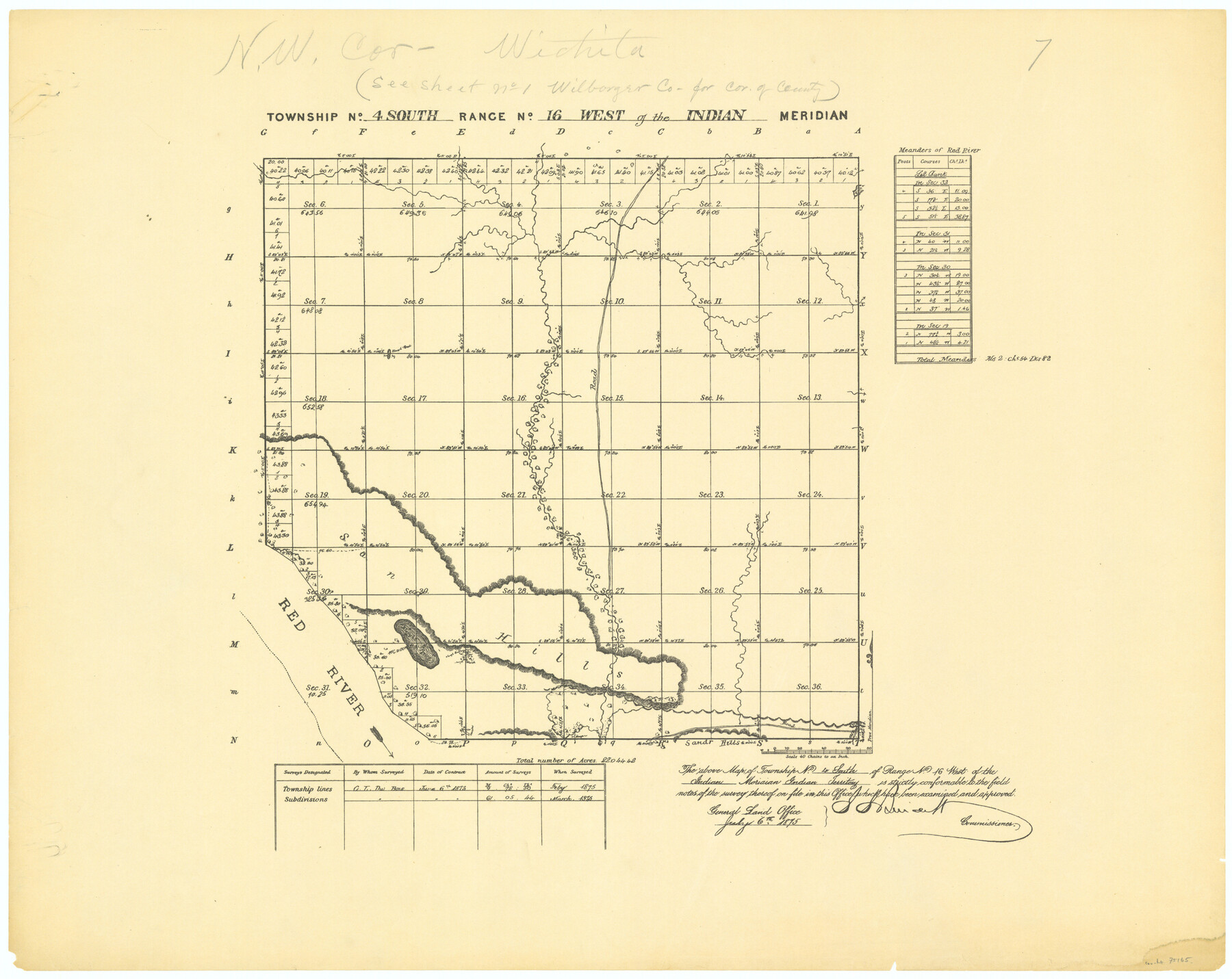
Township No. 4 South Range No. 16 West of the Indian Meridian
-
Map/Doc
75165
-
Collection
General Map Collection
-
Object Dates
1875 (Creation Date)
-
Subjects
Texas Boundaries
-
Height x Width
19.4 x 24.4 inches
49.3 x 62.0 cm
Part of: General Map Collection
Randall County Boundary File 1

Print $26.00
- Digital $50.00
Randall County Boundary File 1
Size 14.0 x 8.5 inches
Map/Doc 58098
Webb County Sketch File 9b

Print $20.00
- Digital $50.00
Webb County Sketch File 9b
1930
Size 15.9 x 16.5 inches
Map/Doc 12620
Terrell County Working Sketch 13

Print $20.00
- Digital $50.00
Terrell County Working Sketch 13
1926
Size 30.1 x 22.8 inches
Map/Doc 62162
Reeves County Boundary File 1

Print $12.00
- Digital $50.00
Reeves County Boundary File 1
Size 14.1 x 8.5 inches
Map/Doc 58195
Angelina County Sketch File 21b

Print $6.00
- Digital $50.00
Angelina County Sketch File 21b
1889
Size 13.9 x 8.5 inches
Map/Doc 13044
McLennan County Sketch File 1a

Print $4.00
- Digital $50.00
McLennan County Sketch File 1a
1872
Size 8.0 x 12.2 inches
Map/Doc 31226
Intracoastal Waterway in Texas - Corpus Christi to Point Isabel including Arroyo Colorado to Mo. Pac. R.R. Bridge Near Harlingen

Print $20.00
- Digital $50.00
Intracoastal Waterway in Texas - Corpus Christi to Point Isabel including Arroyo Colorado to Mo. Pac. R.R. Bridge Near Harlingen
1933
Size 28.4 x 41.2 inches
Map/Doc 61870
Map of Burnet County

Print $20.00
- Digital $50.00
Map of Burnet County
1876
Size 24.5 x 21.3 inches
Map/Doc 3352
Shackelford County Rolled Sketch 5

Print $20.00
- Digital $50.00
Shackelford County Rolled Sketch 5
1984
Size 23.1 x 37.1 inches
Map/Doc 7773
Current Miscellaneous File 45

Print $4.00
- Digital $50.00
Current Miscellaneous File 45
1954
Size 11.2 x 8.8 inches
Map/Doc 73988
Shelby County Rolled Sketch 4

Print $20.00
- Digital $50.00
Shelby County Rolled Sketch 4
1942
Size 36.4 x 43.2 inches
Map/Doc 9920
Upton County Rolled Sketch 48

Print $20.00
- Digital $50.00
Upton County Rolled Sketch 48
1958
Size 27.8 x 27.9 inches
Map/Doc 10694
You may also like
Aransas County NRC Article 33.136 Sketch 12

Print $44.00
- Digital $50.00
Aransas County NRC Article 33.136 Sketch 12
2012
Size 36.0 x 48.0 inches
Map/Doc 94510
Lamar County State Real Property Sketch 1

Print $20.00
- Digital $50.00
Lamar County State Real Property Sketch 1
2013
Size 24.0 x 36.0 inches
Map/Doc 93657
[Right of Way & Track Map, The Texas & Pacific Ry. Co. Main Line]
![64671, [Right of Way & Track Map, The Texas & Pacific Ry. Co. Main Line], General Map Collection](https://historictexasmaps.com/wmedia_w700/maps/64671.tif.jpg)
Print $20.00
- Digital $50.00
[Right of Way & Track Map, The Texas & Pacific Ry. Co. Main Line]
Size 10.8 x 19.0 inches
Map/Doc 64671
Polk County Sketch File 10

Print $4.00
- Digital $50.00
Polk County Sketch File 10
Size 5.2 x 6.4 inches
Map/Doc 34140
General Highway Map of Gaines County, Texas

Print $20.00
- Digital $50.00
General Highway Map of Gaines County, Texas
1951
Size 19.0 x 26.2 inches
Map/Doc 92644
Starr County Sketch File 8

Print $7.00
- Digital $50.00
Starr County Sketch File 8
Size 10.1 x 12.4 inches
Map/Doc 36858
Flight Mission No. DIX-10P, Frame 80, Aransas County

Print $20.00
- Digital $50.00
Flight Mission No. DIX-10P, Frame 80, Aransas County
1956
Size 18.8 x 22.4 inches
Map/Doc 83941
Tom Green County

Print $40.00
- Digital $50.00
Tom Green County
Size 43.6 x 111.2 inches
Map/Doc 82058
[West Half of Potter County, South of River and West Half of Randall County]
![91828, [West Half of Potter County, South of River and West Half of Randall County], Twichell Survey Records](https://historictexasmaps.com/wmedia_w700/maps/91828.tif.jpg)
Print $20.00
- Digital $50.00
[West Half of Potter County, South of River and West Half of Randall County]
Size 25.9 x 43.0 inches
Map/Doc 91828
Van Zandt County Working Sketch 1

Print $20.00
- Digital $50.00
Van Zandt County Working Sketch 1
1946
Size 23.7 x 30.0 inches
Map/Doc 72250
Texas Department of Corrections Prison Unit Locations

Print $20.00
- Digital $50.00
Texas Department of Corrections Prison Unit Locations
1960
Size 37.0 x 45.7 inches
Map/Doc 3104
Hutchinson County Sketch File 5a

Print $6.00
- Digital $50.00
Hutchinson County Sketch File 5a
1900
Size 9.7 x 6.4 inches
Map/Doc 27195