![91214, [Township 3 North, Block 33], Twichell Survey Records](https://historictexasmaps.com/wmedia_w1800h1800/maps/91214-1.tif.jpg)
[Township 3 North, Block 33]
114-12
-
Map/Doc
91214
-
Collection
Twichell Survey Records
-
Counties
Howard
-
Height x Width
11.0 x 11.3 inches
27.9 x 28.7 cm
Part of: Twichell Survey Records
Working Sketch Crockett County

Print $20.00
- Digital $50.00
Working Sketch Crockett County
1924
Size 33.3 x 37.6 inches
Map/Doc 90318
[Sketch of most of Crosby County]
![89762, [Sketch of most of Crosby County], Twichell Survey Records](https://historictexasmaps.com/wmedia_w700/maps/89762-1.tif.jpg)
Print $40.00
- Digital $50.00
[Sketch of most of Crosby County]
Size 54.9 x 45.3 inches
Map/Doc 89762
[School Leagues 245-260, 320-322, 325]
![91342, [School Leagues 245-260, 320-322, 325], Twichell Survey Records](https://historictexasmaps.com/wmedia_w700/maps/91342-1.tif.jpg)
Print $20.00
- Digital $50.00
[School Leagues 245-260, 320-322, 325]
Size 23.3 x 41.4 inches
Map/Doc 91342
D. B. Gardner vs. Mrs. Clara C. Starr, Details 1, 2, 3, and 4

Print $20.00
- Digital $50.00
D. B. Gardner vs. Mrs. Clara C. Starr, Details 1, 2, 3, and 4
Size 25.1 x 30.0 inches
Map/Doc 91045
[Southeast Corner of Glasscock County]
![90786, [Southeast Corner of Glasscock County], Twichell Survey Records](https://historictexasmaps.com/wmedia_w700/maps/90786-1.tif.jpg)
Print $20.00
- Digital $50.00
[Southeast Corner of Glasscock County]
Size 19.2 x 22.5 inches
Map/Doc 90786
![91092, [Block M-23], Twichell Survey Records](https://historictexasmaps.com/wmedia_w700/maps/91092-1.tif.jpg)
[T. H. Jones Blk. O, Blk. F, Coyote Lake Area, Sutton County School Land Leagues]
![90246, [T. H. Jones Blk. O, Blk. F, Coyote Lake Area, Sutton County School Land Leagues], Twichell Survey Records](https://historictexasmaps.com/wmedia_w700/maps/90246-1.tif.jpg)
Print $20.00
- Digital $50.00
[T. H. Jones Blk. O, Blk. F, Coyote Lake Area, Sutton County School Land Leagues]
Size 21.0 x 33.6 inches
Map/Doc 90246
[Block AX and vicinity]
![90860, [Block AX and vicinity], Twichell Survey Records](https://historictexasmaps.com/wmedia_w700/maps/90860-2.tif.jpg)
Print $20.00
- Digital $50.00
[Block AX and vicinity]
Size 35.9 x 19.7 inches
Map/Doc 90860
Myrick Farm Lubbock & Hockley Counties

Print $20.00
- Digital $50.00
Myrick Farm Lubbock & Hockley Counties
Size 21.1 x 18.8 inches
Map/Doc 92831
[Sketch around O. A. Seward surveys]
![91991, [Sketch around O. A. Seward surveys], Twichell Survey Records](https://historictexasmaps.com/wmedia_w700/maps/91991-1.tif.jpg)
Print $20.00
- Digital $50.00
[Sketch around O. A. Seward surveys]
Size 23.4 x 23.9 inches
Map/Doc 91991
Ward County, 1902

Print $40.00
- Digital $50.00
Ward County, 1902
1902
Size 51.8 x 31.3 inches
Map/Doc 89650
[East Line and Red River Railroad Company, Block Z and vicinity]
![91256, [East Line and Red River Railroad Company, Block Z and vicinity], Twichell Survey Records](https://historictexasmaps.com/wmedia_w700/maps/91256-1.tif.jpg)
Print $20.00
- Digital $50.00
[East Line and Red River Railroad Company, Block Z and vicinity]
1878
Size 27.8 x 22.1 inches
Map/Doc 91256
You may also like
San Jacinto County Working Sketch 23

Print $40.00
- Digital $50.00
San Jacinto County Working Sketch 23
1940
Size 31.5 x 53.8 inches
Map/Doc 63736
Harris County Historic Topographic 4

Print $20.00
- Digital $50.00
Harris County Historic Topographic 4
1916
Size 14.5 x 24.6 inches
Map/Doc 65814
Map of Wharton County
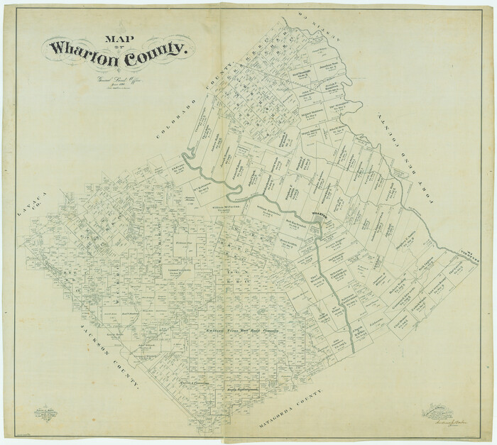
Print $40.00
- Digital $50.00
Map of Wharton County
1895
Size 48.2 x 53.8 inches
Map/Doc 82055
Brewster County Working Sketch 87

Print $40.00
- Digital $50.00
Brewster County Working Sketch 87
1973
Size 37.4 x 56.6 inches
Map/Doc 67687
Burleson County Working Sketch 10

Print $3.00
- Digital $50.00
Burleson County Working Sketch 10
1980
Size 15.1 x 9.7 inches
Map/Doc 67729
Crockett County Rolled Sketch 60

Print $20.00
- Digital $50.00
Crockett County Rolled Sketch 60
Size 18.7 x 18.9 inches
Map/Doc 5603
Coke County Rolled Sketch 19A

Print $20.00
- Digital $50.00
Coke County Rolled Sketch 19A
1954
Size 19.9 x 24.8 inches
Map/Doc 5520
General Highway Map, Randall County, Texas

Print $20.00
General Highway Map, Randall County, Texas
1940
Size 18.3 x 25.0 inches
Map/Doc 79224
Lavaca County Working Sketch 25

Print $20.00
- Digital $50.00
Lavaca County Working Sketch 25
1986
Size 33.3 x 29.9 inches
Map/Doc 70378
Crockett County Sketch File 95

Print $24.00
- Digital $50.00
Crockett County Sketch File 95
Size 11.2 x 8.9 inches
Map/Doc 19952
Hale County Boundary File 10

Print $62.00
- Digital $50.00
Hale County Boundary File 10
Size 37.9 x 9.4 inches
Map/Doc 54145
