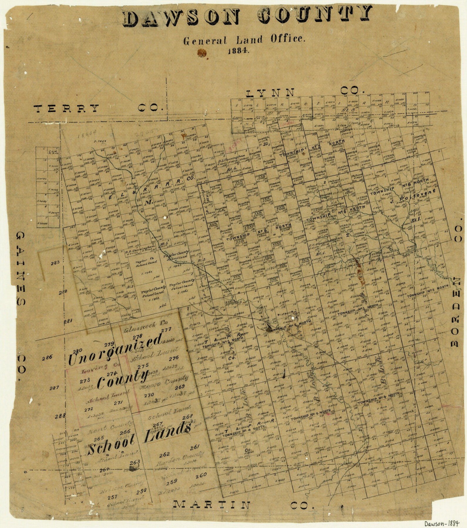
Dawson County
-
Map/Doc
3469
-
Collection
General Map Collection
-
Object Dates
1884 (Creation Date)
-
Counties
Dawson
-
Subjects
County
-
Height x Width
21.8 x 19.4 inches
55.4 x 49.3 cm
-
Features
Sulphur Springs Creek
Manie's [sic] Spring Creek
Colorado River
Part of: General Map Collection
Flight Mission No. DAG-21K, Frame 96, Matagorda County

Print $20.00
- Digital $50.00
Flight Mission No. DAG-21K, Frame 96, Matagorda County
1952
Size 18.4 x 22.4 inches
Map/Doc 86425
Henderson County Sketch File 22

Print $14.00
- Digital $50.00
Henderson County Sketch File 22
1942
Size 14.2 x 8.9 inches
Map/Doc 26365
Pecos County Working Sketch 48

Print $20.00
- Digital $50.00
Pecos County Working Sketch 48
1947
Size 35.0 x 27.7 inches
Map/Doc 71520
Sutton County Working Sketch 65

Print $20.00
- Digital $50.00
Sutton County Working Sketch 65
1963
Size 20.4 x 39.5 inches
Map/Doc 62408
Sherman County Boundary File 2

Print $34.00
- Digital $50.00
Sherman County Boundary File 2
Size 13.0 x 9.0 inches
Map/Doc 58761
Flight Mission No. CRE-1R, Frame 123, Jackson County

Print $20.00
- Digital $50.00
Flight Mission No. CRE-1R, Frame 123, Jackson County
1956
Size 16.0 x 16.0 inches
Map/Doc 85334

Liberty County Sketch File 6

Print $6.00
- Digital $50.00
Liberty County Sketch File 6
1856
Size 12.1 x 7.7 inches
Map/Doc 29893
Fractional Township No. 8 South Range No. 1 East of the Indian Meridian, Indian Territory

Print $20.00
- Digital $50.00
Fractional Township No. 8 South Range No. 1 East of the Indian Meridian, Indian Territory
1898
Size 19.3 x 24.3 inches
Map/Doc 75200
Maps & Lists Showing Prison Lands (Oil & Gas) Leased as of June 1955

Digital $50.00
Maps & Lists Showing Prison Lands (Oil & Gas) Leased as of June 1955
1930
Size 24.4 x 26.8 inches
Map/Doc 62876
Pecos County Rolled Sketch 51

Print $20.00
- Digital $50.00
Pecos County Rolled Sketch 51
1914
Size 8.6 x 35.5 inches
Map/Doc 7227
Bandera County Sketch File 20

Print $40.00
- Digital $50.00
Bandera County Sketch File 20
Size 18.7 x 13.6 inches
Map/Doc 10894
You may also like
Val Verde County Working Sketch 117

Print $20.00
- Digital $50.00
Val Verde County Working Sketch 117
1993
Size 13.5 x 36.7 inches
Map/Doc 82847
The Sunshine Special - Quickest of 'em all - Hosuton to St. Louis leaves Houston 12:45 p.m. San Antonio 9 a.m.

Print $20.00
- Digital $50.00
The Sunshine Special - Quickest of 'em all - Hosuton to St. Louis leaves Houston 12:45 p.m. San Antonio 9 a.m.
1925
Size 9.0 x 7.7 inches
Map/Doc 95780
Wise County Working Sketch 1

Print $20.00
- Digital $50.00
Wise County Working Sketch 1
1929
Size 22.4 x 19.4 inches
Map/Doc 72615
Buchanan Dam Reservoir Clearing

Print $20.00
- Digital $50.00
Buchanan Dam Reservoir Clearing
1935
Size 21.8 x 40.4 inches
Map/Doc 60393
Map of Briscoe County

Print $20.00
- Digital $50.00
Map of Briscoe County
1901
Size 41.4 x 38.0 inches
Map/Doc 4893
Presidio County Rolled Sketch 66

Print $20.00
- Digital $50.00
Presidio County Rolled Sketch 66
1920
Size 19.4 x 37.5 inches
Map/Doc 7357
Liberty County Sketch File 10

Print $4.00
- Digital $50.00
Liberty County Sketch File 10
1858
Size 9.5 x 8.9 inches
Map/Doc 29903
General Highway Map, Rains County, Wood County, Texas

Print $20.00
General Highway Map, Rains County, Wood County, Texas
1939
Size 18.2 x 24.8 inches
Map/Doc 79223
Brooks County Working Sketch 10

Print $20.00
- Digital $50.00
Brooks County Working Sketch 10
1939
Size 32.1 x 32.8 inches
Map/Doc 67794
Flight Mission No. BRA-7M, Frame 130, Jefferson County

Print $20.00
- Digital $50.00
Flight Mission No. BRA-7M, Frame 130, Jefferson County
1953
Size 16.2 x 16.0 inches
Map/Doc 85524
Young County Working Sketch 20

Print $20.00
- Digital $50.00
Young County Working Sketch 20
1961
Size 25.5 x 23.2 inches
Map/Doc 62043
Lamar County State Real Property Sketch 1

Print $20.00
- Digital $50.00
Lamar County State Real Property Sketch 1
2013
Size 24.0 x 36.0 inches
Map/Doc 93658