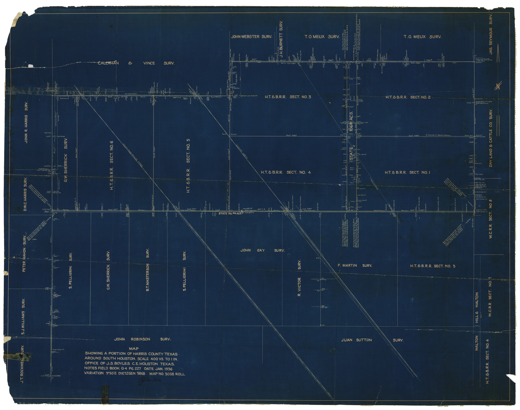
Harris County Rolled Sketch 63
Map showing a portion of Harris County, Texas around south Houston
-
Map/Doc
9120
-
Collection
General Map Collection
-
Object Dates
1936 (Creation Date)
-
People and Organizations
J.S. Boyles (Surveyor/Engineer)
-
Counties
Harris
-
Subjects
Surveying Rolled Sketch
-
Height x Width
41.4 x 52.5 inches
105.2 x 133.4 cm
-
Medium
blueprint/diazo
-
Scale
1" = 400 varas
Part of: General Map Collection
Territory served by the Galveston Bay Ports, Tex.

Print $20.00
- Digital $50.00
Territory served by the Galveston Bay Ports, Tex.
Size 17.1 x 16.0 inches
Map/Doc 97165
Bandera County Boundary File 4

Print $18.00
- Digital $50.00
Bandera County Boundary File 4
Size 8.9 x 7.7 inches
Map/Doc 50267
Presidio County Working Sketch 56

Print $20.00
- Digital $50.00
Presidio County Working Sketch 56
1955
Size 13.9 x 22.0 inches
Map/Doc 71733
Grant of Miguel Rabago

Print $2.00
- Digital $50.00
Grant of Miguel Rabago
Size 8.6 x 8.4 inches
Map/Doc 76047
[Surveys in the Nacogdoches District, from the Sabine River to Cowleach Fork]
![282, [Surveys in the Nacogdoches District, from the Sabine River to Cowleach Fork], General Map Collection](https://historictexasmaps.com/wmedia_w700/maps/282.tif.jpg)
Print $3.00
- Digital $50.00
[Surveys in the Nacogdoches District, from the Sabine River to Cowleach Fork]
Size 15.6 x 11.5 inches
Map/Doc 282
Cooke County Sketch File 12

Print $4.00
- Digital $50.00
Cooke County Sketch File 12
Size 10.1 x 8.3 inches
Map/Doc 19246
Johnson County Sketch File 22

Print $20.00
- Digital $50.00
Johnson County Sketch File 22
1873
Size 18.8 x 16.2 inches
Map/Doc 11891
University Land, Block 48, Culberson County, Texas

Print $20.00
- Digital $50.00
University Land, Block 48, Culberson County, Texas
1938
Size 28.1 x 21.7 inches
Map/Doc 2411
Johnson County Working Sketch 31

Print $20.00
- Digital $50.00
Johnson County Working Sketch 31
2007
Size 21.2 x 22.0 inches
Map/Doc 87499
McMullen County Sketch File 6

Print $4.00
- Digital $50.00
McMullen County Sketch File 6
Size 7.1 x 5.4 inches
Map/Doc 31345
[Location Survey of the Southern Kansas Railway, Kiowa Extension from a point in Drake's Location, in Indian Territory 100 miles from south line of Kansas, continuing up Wolf Creek and South Canadian River to Cottonwood Creek in Hutchinson County]
![88840, [Location Survey of the Southern Kansas Railway, Kiowa Extension from a point in Drake's Location, in Indian Territory 100 miles from south line of Kansas, continuing up Wolf Creek and South Canadian River to Cottonwood Creek in Hutchinson County], General Map Collection](https://historictexasmaps.com/wmedia_w700/maps/88840.tif.jpg)
Print $20.00
- Digital $50.00
[Location Survey of the Southern Kansas Railway, Kiowa Extension from a point in Drake's Location, in Indian Territory 100 miles from south line of Kansas, continuing up Wolf Creek and South Canadian River to Cottonwood Creek in Hutchinson County]
1886
Size 39.1 x 38.0 inches
Map/Doc 88840
[Right of Way & Track Map, The Texas & Pacific Ry. Co. Main Line]
![64659, [Right of Way & Track Map, The Texas & Pacific Ry. Co. Main Line], General Map Collection](https://historictexasmaps.com/wmedia_w700/maps/64659.tif.jpg)
Print $20.00
- Digital $50.00
[Right of Way & Track Map, The Texas & Pacific Ry. Co. Main Line]
Size 11.0 x 18.4 inches
Map/Doc 64659
You may also like
Val Verde County Rolled Sketch 61

Print $20.00
- Digital $50.00
Val Verde County Rolled Sketch 61
1938
Size 27.3 x 24.2 inches
Map/Doc 8128
Parker County Sketch File 3a

Print $40.00
- Digital $50.00
Parker County Sketch File 3a
Size 12.7 x 12.8 inches
Map/Doc 33523
Flight Mission No. BQY-4M, Frame 55, Harris County

Print $20.00
- Digital $50.00
Flight Mission No. BQY-4M, Frame 55, Harris County
1953
Size 18.5 x 22.3 inches
Map/Doc 85264
Rains County Rolled Sketch 2

Print $41.00
- Digital $50.00
Rains County Rolled Sketch 2
1958
Size 10.4 x 15.4 inches
Map/Doc 48829
Travis County Sketch File 13

Print $4.00
- Digital $50.00
Travis County Sketch File 13
1858
Size 8.2 x 6.5 inches
Map/Doc 38306
Concho County Sketch File 31

Print $30.00
- Digital $50.00
Concho County Sketch File 31
1911
Size 11.2 x 9.0 inches
Map/Doc 19175
Swisher County Sketch File 7

Print $32.00
- Digital $50.00
Swisher County Sketch File 7
1904
Size 9.0 x 8.4 inches
Map/Doc 37622
Southern Part of Laguna Madre

Print $20.00
- Digital $50.00
Southern Part of Laguna Madre
1972
Size 44.3 x 35.6 inches
Map/Doc 73542
[Blk. B, part of Blk. M, and north line of Morris County School Land]
![90359, [Blk. B, part of Blk. M, and north line of Morris County School Land], Twichell Survey Records](https://historictexasmaps.com/wmedia_w700/maps/90359-1.tif.jpg)
Print $20.00
- Digital $50.00
[Blk. B, part of Blk. M, and north line of Morris County School Land]
Size 23.9 x 22.7 inches
Map/Doc 90359
Kleberg County Boundary File 2c

Print $40.00
- Digital $50.00
Kleberg County Boundary File 2c
Size 8.8 x 49.6 inches
Map/Doc 64979
Refugio County Rolled Sketch 6

Print $20.00
- Digital $50.00
Refugio County Rolled Sketch 6
1892
Size 28.7 x 29.2 inches
Map/Doc 7507
Wood County Sketch File 2

Print $4.00
- Digital $50.00
Wood County Sketch File 2
1848
Size 8.3 x 6.4 inches
Map/Doc 40631