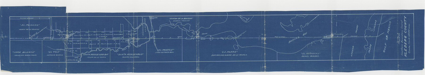
Kleberg County Boundary File 2c
Map of the Southern Boundary line of Kleberg County
-
Map/Doc
64979
-
Collection
General Map Collection
-
Counties
Kleberg
-
Subjects
County Boundaries
-
Height x Width
8.8 x 49.6 inches
22.4 x 126.0 cm
Part of: General Map Collection
Reeves County Working Sketch 27

Print $20.00
- Digital $50.00
Reeves County Working Sketch 27
1967
Size 40.2 x 43.0 inches
Map/Doc 63470
Eastland County Working Sketch 63

Print $20.00
- Digital $50.00
Eastland County Working Sketch 63
1997
Size 36.7 x 37.6 inches
Map/Doc 68844
Right of Way & Track Map San Antonio & Aransas Pass Railway Co.

Print $40.00
- Digital $50.00
Right of Way & Track Map San Antonio & Aransas Pass Railway Co.
1919
Size 25.8 x 57.1 inches
Map/Doc 64027
Jasper County Rolled Sketch 3

Print $20.00
- Digital $50.00
Jasper County Rolled Sketch 3
1944
Size 24.5 x 43.4 inches
Map/Doc 6350
[Sketch for Mineral Application 26501 - Sabine River, T. A. Oldhausen]
![2832, [Sketch for Mineral Application 26501 - Sabine River, T. A. Oldhausen], General Map Collection](https://historictexasmaps.com/wmedia_w700/maps/2832.tif.jpg)
Print $20.00
- Digital $50.00
[Sketch for Mineral Application 26501 - Sabine River, T. A. Oldhausen]
1931
Size 24.0 x 36.0 inches
Map/Doc 2832
Matagorda County Rolled Sketch 20

Print $20.00
- Digital $50.00
Matagorda County Rolled Sketch 20
1938
Size 25.1 x 30.6 inches
Map/Doc 6688
Map of Schleicher Co.

Print $20.00
- Digital $50.00
Map of Schleicher Co.
1891
Size 24.4 x 32.5 inches
Map/Doc 63024
Winkler County Rolled Sketch 12

Print $20.00
- Digital $50.00
Winkler County Rolled Sketch 12
1965
Size 24.9 x 18.5 inches
Map/Doc 8279
Terrell County Working Sketch 22a

Print $20.00
- Digital $50.00
Terrell County Working Sketch 22a
1939
Size 39.8 x 40.9 inches
Map/Doc 71493
[Surveys near the Medina River, Bexar District]
![230, [Surveys near the Medina River, Bexar District], General Map Collection](https://historictexasmaps.com/wmedia_w700/maps/230.tif.jpg)
Print $2.00
- Digital $50.00
[Surveys near the Medina River, Bexar District]
1847
Size 13.1 x 8.0 inches
Map/Doc 230
Flight Mission No. DAG-14K, Frame 135, Matagorda County

Print $20.00
- Digital $50.00
Flight Mission No. DAG-14K, Frame 135, Matagorda County
1952
Size 17.7 x 17.5 inches
Map/Doc 86306
Reeves County Working Sketch 52

Print $40.00
- Digital $50.00
Reeves County Working Sketch 52
1977
Size 60.3 x 41.9 inches
Map/Doc 63495
You may also like
[Rio Grande & Eagle Pass - Stockdale to Cuero]
![64049, [Rio Grande & Eagle Pass - Stockdale to Cuero], General Map Collection](https://historictexasmaps.com/wmedia_w700/maps/64049.tif.jpg)
Print $40.00
- Digital $50.00
[Rio Grande & Eagle Pass - Stockdale to Cuero]
Size 19.1 x 98.7 inches
Map/Doc 64049
Caldwell County

Print $20.00
- Digital $50.00
Caldwell County
1935
Size 39.6 x 43.7 inches
Map/Doc 1791
McLennan County Working Sketch 7

Print $20.00
- Digital $50.00
McLennan County Working Sketch 7
1959
Size 22.6 x 23.9 inches
Map/Doc 70700
Map of Texas with Parts of the Adjoining States

Print $20.00
Map of Texas with Parts of the Adjoining States
1836
Size 29.8 x 24.1 inches
Map/Doc 93963
Hartley County Sketch File 1

Print $40.00
- Digital $50.00
Hartley County Sketch File 1
Size 9.7 x 18.4 inches
Map/Doc 11696
![88910, Bosque Co[unty], Library of Congress](https://historictexasmaps.com/wmedia_w700/maps/88910.tif.jpg)
Leon County Working Sketch Graphic Index

Print $20.00
- Digital $50.00
Leon County Working Sketch Graphic Index
1977
Size 46.8 x 41.5 inches
Map/Doc 76618
Kerr County Working Sketch 17

Print $20.00
- Digital $50.00
Kerr County Working Sketch 17
1956
Size 20.0 x 23.7 inches
Map/Doc 70048
Starr County Rolled Sketch 40

Print $20.00
- Digital $50.00
Starr County Rolled Sketch 40
1961
Size 21.3 x 22.6 inches
Map/Doc 7834
Flight Mission No. DCL-5C, Frame 71, Kenedy County

Print $20.00
- Digital $50.00
Flight Mission No. DCL-5C, Frame 71, Kenedy County
1943
Size 18.5 x 22.2 inches
Map/Doc 85854
Harris County Working Sketch 67

Print $20.00
- Digital $50.00
Harris County Working Sketch 67
1955
Size 23.3 x 27.5 inches
Map/Doc 65959
Packery Channel

Print $20.00
- Digital $50.00
Packery Channel
1950
Size 17.2 x 17.1 inches
Map/Doc 2996