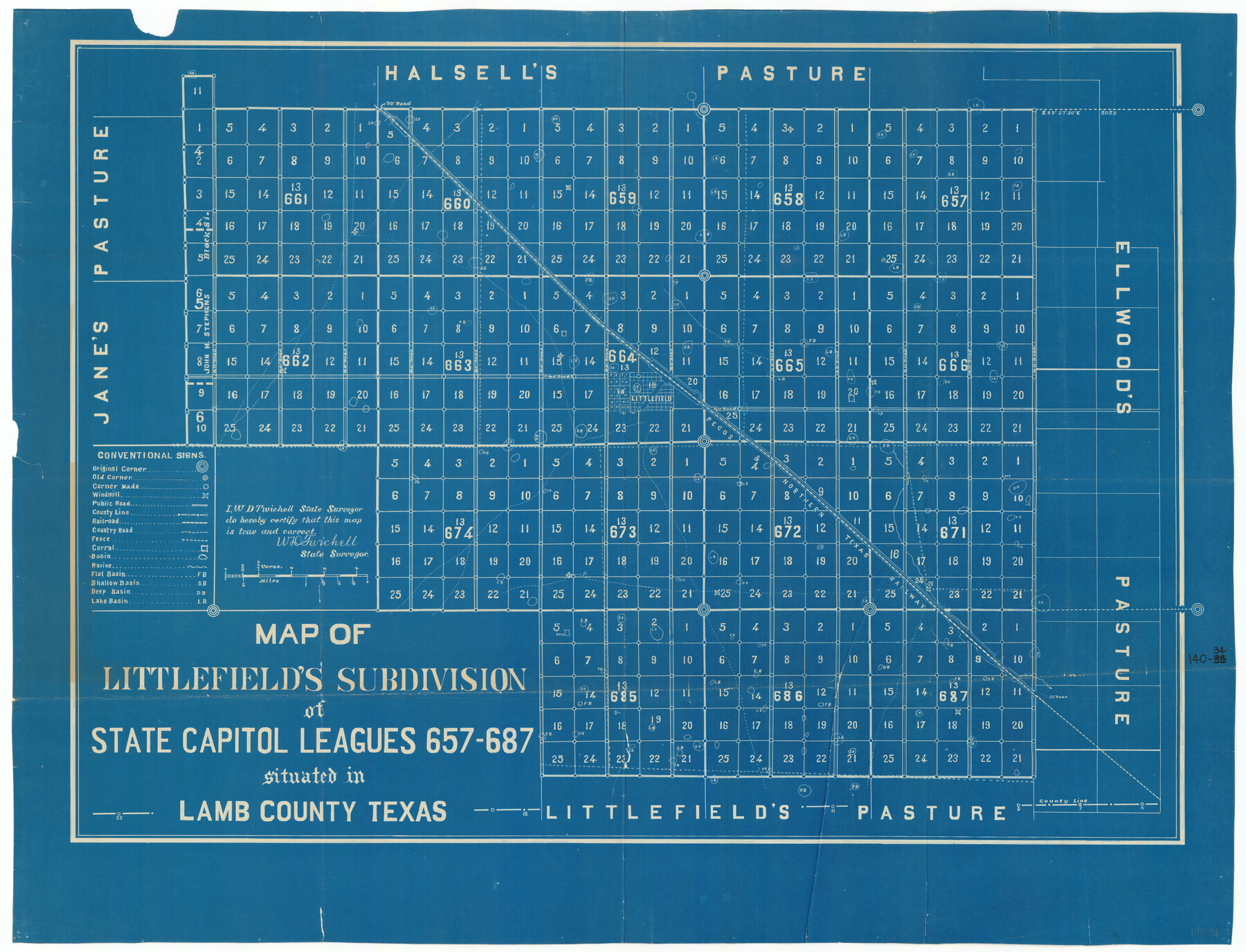
Map of Littlefield's Subdivision of State Capitol Leagues 657- 687
140-34
-
Map/Doc
91025
-
Collection
Twichell Survey Records
-
People and Organizations
W.D. Twichell (Surveyor/Engineer)
-
Counties
Lamb
-
Height x Width
38.0 x 29.2 inches
96.5 x 74.2 cm
Part of: Twichell Survey Records
[SW Corner of Lynn County]
![92903, [SW Corner of Lynn County], Twichell Survey Records](https://historictexasmaps.com/wmedia_w700/maps/92903-1.tif.jpg)
Print $20.00
- Digital $50.00
[SW Corner of Lynn County]
1954
Size 32.2 x 31.1 inches
Map/Doc 92903
[H. & T. C. Block 47 and Vicinity]
![91423, [H. & T. C. Block 47 and Vicinity], Twichell Survey Records](https://historictexasmaps.com/wmedia_w700/maps/91423-1.tif.jpg)
Print $20.00
- Digital $50.00
[H. & T. C. Block 47 and Vicinity]
1887
Size 16.3 x 18.8 inches
Map/Doc 91423
[Norwood Homestead]
![91879, [Norwood Homestead], Twichell Survey Records](https://historictexasmaps.com/wmedia_w700/maps/91879-1.tif.jpg)
Print $20.00
- Digital $50.00
[Norwood Homestead]
Size 21.1 x 21.8 inches
Map/Doc 91879
Lgs. 276 thru 280-289, 333, 336, 345, 355 thru 357, 367, Blk. K11

Print $20.00
- Digital $50.00
Lgs. 276 thru 280-289, 333, 336, 345, 355 thru 357, 367, Blk. K11
Size 28.0 x 12.3 inches
Map/Doc 91429
Map of George W. Littlefield's Ranch Located on State Capitol Leagues 657-736 Situated in Lamb and Hockley Counties, Texas

Print $20.00
- Digital $50.00
Map of George W. Littlefield's Ranch Located on State Capitol Leagues 657-736 Situated in Lamb and Hockley Counties, Texas
Size 27.9 x 37.9 inches
Map/Doc 92262
[Sketch showing H. T. & B. section 126 and B. H. Epperson]
![90932, [Sketch showing H. T. & B. section 126 and B. H. Epperson], Twichell Survey Records](https://historictexasmaps.com/wmedia_w700/maps/90932-1.tif.jpg)
Print $20.00
- Digital $50.00
[Sketch showing H. T. & B. section 126 and B. H. Epperson]
Size 23.9 x 32.5 inches
Map/Doc 90932
[Sketch showing parts of Blocks 3, 5, 22, M-20, S, T and Block BB, surveys 1, 2 and 3]
![91730, [Sketch showing parts of Blocks 3, 5, 22, M-20, S, T and Block BB, surveys 1, 2 and 3], Twichell Survey Records](https://historictexasmaps.com/wmedia_w700/maps/91730-1.tif.jpg)
Print $20.00
- Digital $50.00
[Sketch showing parts of Blocks 3, 5, 22, M-20, S, T and Block BB, surveys 1, 2 and 3]
Size 15.5 x 15.9 inches
Map/Doc 91730
[Leagues along West line of County]
![90547, [Leagues along West line of County], Twichell Survey Records](https://historictexasmaps.com/wmedia_w700/maps/90547-1.tif.jpg)
Print $2.00
- Digital $50.00
[Leagues along West line of County]
Size 5.7 x 11.6 inches
Map/Doc 90547
[North County Line]
![90521, [North County Line], Twichell Survey Records](https://historictexasmaps.com/wmedia_w700/maps/90521-1.tif.jpg)
Print $3.00
- Digital $50.00
[North County Line]
Size 17.3 x 6.6 inches
Map/Doc 90521
[Parts of Blocks M-20, 22 and S]
![91825, [Parts of Blocks M-20, 22 and S], Twichell Survey Records](https://historictexasmaps.com/wmedia_w700/maps/91825-1.tif.jpg)
Print $20.00
- Digital $50.00
[Parts of Blocks M-20, 22 and S]
1921
Size 23.3 x 18.3 inches
Map/Doc 91825
University of Texas System University Lands

Print $20.00
- Digital $50.00
University of Texas System University Lands
Size 23.1 x 17.5 inches
Map/Doc 93238
[League 27, Montgomery County School Land, William Tubbs Survey]
![91127, [League 27, Montgomery County School Land, William Tubbs Survey], Twichell Survey Records](https://historictexasmaps.com/wmedia_w700/maps/91127-1.tif.jpg)
Print $2.00
- Digital $50.00
[League 27, Montgomery County School Land, William Tubbs Survey]
Size 11.7 x 8.9 inches
Map/Doc 91127
You may also like
Travis County Sketch File ABC

Print $20.00
- Digital $50.00
Travis County Sketch File ABC
Size 23.8 x 19.0 inches
Map/Doc 12480
Fisher County Working Sketch 12

Print $20.00
- Digital $50.00
Fisher County Working Sketch 12
1956
Size 25.2 x 23.2 inches
Map/Doc 69146
Knox County Sketch File 22

Print $6.00
- Digital $50.00
Knox County Sketch File 22
1931
Size 11.2 x 8.8 inches
Map/Doc 29251
Jeff Davis County Rolled Sketch 21

Print $20.00
- Digital $50.00
Jeff Davis County Rolled Sketch 21
1946
Size 46.5 x 38.7 inches
Map/Doc 9267
Mason County Working Sketch 23

Print $20.00
- Digital $50.00
Mason County Working Sketch 23
2004
Size 17.4 x 36.9 inches
Map/Doc 83577
Zavala County Rolled Sketch 28

Print $20.00
- Digital $50.00
Zavala County Rolled Sketch 28
1956
Size 29.6 x 41.2 inches
Map/Doc 8330
[Blocks 46, XO3, and Y]
![91181, [Blocks 46, XO3, and Y], Twichell Survey Records](https://historictexasmaps.com/wmedia_w700/maps/91181-1.tif.jpg)
Print $3.00
- Digital $50.00
[Blocks 46, XO3, and Y]
Size 9.8 x 16.0 inches
Map/Doc 91181
Donley County Sketch File 5

Print $14.00
- Digital $50.00
Donley County Sketch File 5
Size 12.9 x 8.5 inches
Map/Doc 21223
Webb County Working Sketch 2

Print $20.00
- Digital $50.00
Webb County Working Sketch 2
1906
Size 11.2 x 12.5 inches
Map/Doc 72367
Presidio County Working Sketch 78

Print $20.00
- Digital $50.00
Presidio County Working Sketch 78
1965
Size 24.8 x 25.1 inches
Map/Doc 71755
Surveys in Reeves and Culberson Counties, Texas and Pacific Railroad Company, Blocks 58, 59, 60, and 61

Print $20.00
- Digital $50.00
Surveys in Reeves and Culberson Counties, Texas and Pacific Railroad Company, Blocks 58, 59, 60, and 61
1937
Size 30.7 x 25.3 inches
Map/Doc 2250
Nueces County Rolled Sketch 3
Print $20.00
- Digital $50.00
Nueces County Rolled Sketch 3
1907
Size 17.3 x 34.2 inches
Map/Doc 6866