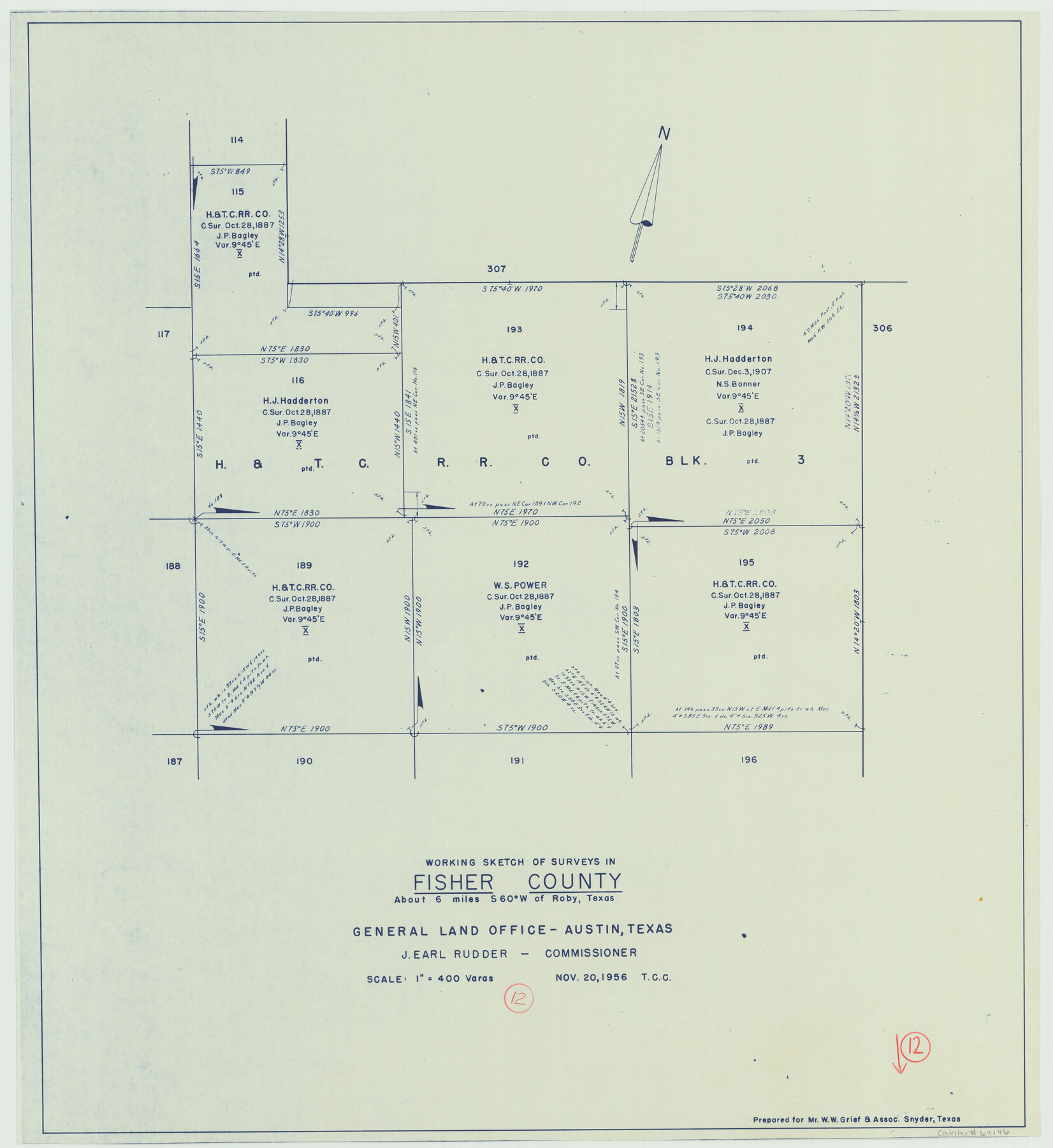
Fisher County Working Sketch 12
- 
                          Map/Doc
69146
 - 
                            Collection
General Map Collection
 - 
                            Object Dates
11/20/1956 (Creation Date)
 - 
                            Counties
Fisher
 - 
                            Subjects
Surveying Working Sketch
 - 
                            Height x Width
25.2 x 23.2 inches
64.0 x 58.9 cm
 - 
                            Scale
1" = 400 varas
 
Part of: General Map Collection
            Map of Travis County


                                            Print $20.00                    
                                             -                         Digital $50.00                                    
                Map of Travis County
1861
Size 21.2 x 25.3 inches
                                Map/Doc 4087
            
            Texas Gulf Coast from Sabine River to the Rio Grande


                                            Print $20.00                    
                                             -                         Digital $50.00                                    
                Texas Gulf Coast from Sabine River to the Rio Grande
1953
Size 45.9 x 43.6 inches
                                Map/Doc 2945
            
            Amistad International Reservoir on Rio Grande 97


                                            Print $20.00                    
                                             -                         Digital $50.00                                    
                Amistad International Reservoir on Rio Grande 97
1950
Size 28.5 x 41.1 inches
                                Map/Doc 75528
            
            Flight Mission No. DCL-6C, Frame 118, Kenedy County


                                            Print $20.00                    
                                             -                         Digital $50.00                                    
                Flight Mission No. DCL-6C, Frame 118, Kenedy County
1943
Size 18.6 x 22.4 inches
                                Map/Doc 85948
            
            Harris County Sketch File 9


                                            Print $4.00                    
                                             -                         Digital $50.00                                    
                Harris County Sketch File 9
1861
Size 6.7 x 7.3 inches
                                Map/Doc 25340
            
            Denton County Sketch File 3


                                            Print $4.00                    
                                             -                         Digital $50.00                                    
                Denton County Sketch File 3
1855
Size 12.5 x 8.2 inches
                                Map/Doc 20688
            
            Borden County Sketch File 1


                                            Print $6.00                    
                                             -                         Digital $50.00                                    
                Borden County Sketch File 1
Size 16.2 x 11.0 inches
                                Map/Doc 14701
            
            Baylor County Working Sketch 14


                                            Print $40.00                    
                                             -                         Digital $50.00                                    
                Baylor County Working Sketch 14
1982
Size 33.5 x 55.1 inches
                                Map/Doc 67299
            
            Controlled Mosaic by Jack Amman Photogrammetric Engineers, Inc - Sheet 49


                                            Print $20.00                    
                                             -                         Digital $50.00                                    
                Controlled Mosaic by Jack Amman Photogrammetric Engineers, Inc - Sheet 49
1954
Size 20.0 x 24.0 inches
                                Map/Doc 83508
            
            Flight Mission No. DCL-6C, Frame 46, Kenedy County


                                            Print $20.00                    
                                             -                         Digital $50.00                                    
                Flight Mission No. DCL-6C, Frame 46, Kenedy County
1943
Size 18.6 x 22.3 inches
                                Map/Doc 85888
            
            Throckmorton County


                                            Print $20.00                    
                                             -                         Digital $50.00                                    
                Throckmorton County
1943
Size 47.8 x 38.2 inches
                                Map/Doc 63065
            
            A Survey of Lake Champlain, including Lake George, Crown Point and St. John


                                            Print $20.00                    
                                             -                         Digital $50.00                                    
                A Survey of Lake Champlain, including Lake George, Crown Point and St. John
1762
Size 29.0 x 20.9 inches
                                Map/Doc 97404
            You may also like
            Bexar County Sketch File 58


                                            Print $4.00                    
                                             -                         Digital $50.00                                    
                Bexar County Sketch File 58
1847
Size 10.4 x 8.3 inches
                                Map/Doc 14572
            
            Montague County Sketch File 11


                                            Print $4.00                    
                                             -                         Digital $50.00                                    
                Montague County Sketch File 11
1873
Size 12.2 x 8.4 inches
                                Map/Doc 31734
            
            Flight Mission No. DAG-21K, Frame 39, Matagorda County


                                            Print $20.00                    
                                             -                         Digital $50.00                                    
                Flight Mission No. DAG-21K, Frame 39, Matagorda County
1952
Size 18.6 x 22.3 inches
                                Map/Doc 86406
            
            Southern Part of Laguna Madre


                                            Print $20.00                    
                                             -                         Digital $50.00                                    
                Southern Part of Laguna Madre
1981
Size 45.1 x 35.8 inches
                                Map/Doc 73546
            
            Glasscock County Sketch File 23


                                            Print $10.00                    
                                             -                         Digital $50.00                                    
                Glasscock County Sketch File 23
1948
Size 11.4 x 8.8 inches
                                Map/Doc 24199
            
            Mason County Boundary File 1


                                            Print $2.00                    
                                             -                         Digital $50.00                                    
                Mason County Boundary File 1
Size 12.7 x 8.2 inches
                                Map/Doc 56829
            
            Andrews County Working Sketch 31


                                            Print $20.00                    
                                             -                         Digital $50.00                                    
                Andrews County Working Sketch 31
1990
Size 42.9 x 30.0 inches
                                Map/Doc 67077
            
            Kerr County Sketch File 6b


                                            Print $4.00                    
                                             -                         Digital $50.00                                    
                Kerr County Sketch File 6b
1880
Size 8.5 x 13.6 inches
                                Map/Doc 28867
            
            Current Miscellaneous File 104


                                            Print $8.00                    
                                             -                         Digital $50.00                                    
                Current Miscellaneous File 104
1845
Size 11.0 x 16.8 inches
                                Map/Doc 74677
            
            McMullen County Working Sketch 22


                                            Print $40.00                    
                                             -                         Digital $50.00                                    
                McMullen County Working Sketch 22
1947
Size 39.1 x 53.3 inches
                                Map/Doc 70723
            
            Coryell County Working Sketch 14


                                            Print $20.00                    
                                             -                         Digital $50.00                                    
                Coryell County Working Sketch 14
1950
Size 19.4 x 17.5 inches
                                Map/Doc 68221
            
            Marion County Sketch File 2


                                            Print $4.00                    
                                             -                         Digital $50.00                                    
                Marion County Sketch File 2
1853
Size 8.3 x 14.2 inches
                                Map/Doc 30564