Zavala County Rolled Sketch 28
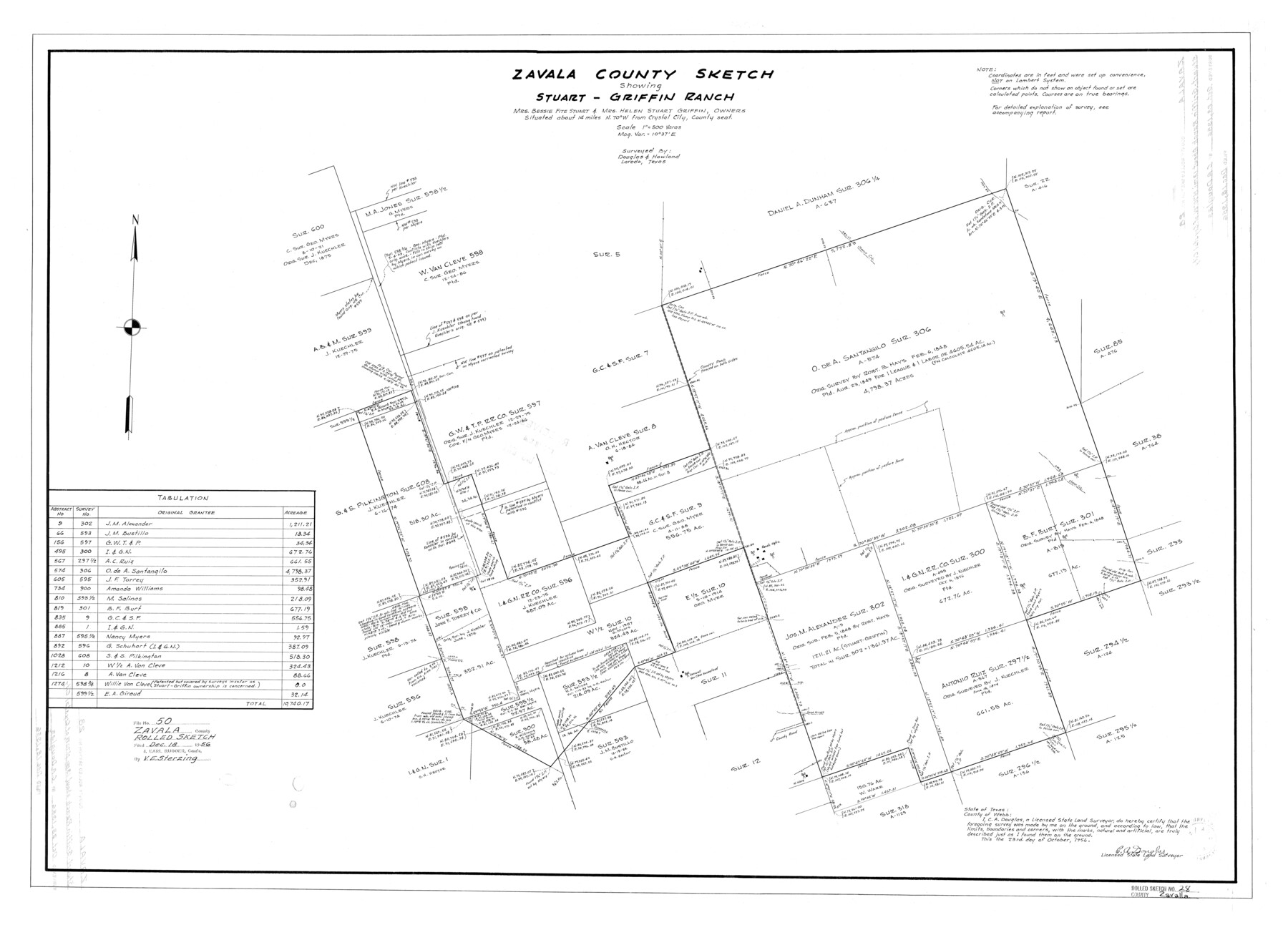
Zavala County sketch showing Stuart-Griffin Ranch, Mrs. Bessie Fite Stuart & Mrs. Helen Stuart Griffin, owners
-
Map/Doc
8330
-
Collection
General Map Collection
-
Object Dates
1956/10/23 (Creation Date)
1956/12/18 (File Date)
-
People and Organizations
C.A. Douglas (Surveyor/Engineer)
-
Counties
Zavala
-
Subjects
Surveying Rolled Sketch
-
Height x Width
29.6 x 41.2 inches
75.2 x 104.6 cm
-
Scale
1" = 500 varas
Related maps
Zavala County Sketch File 50

Print $10.00
- Digital $50.00
Zavala County Sketch File 50
1956
Size 14.6 x 9.1 inches
Map/Doc 41446
Part of: General Map Collection
Flight Mission No. DQO-1K, Frame 113, Galveston County

Print $20.00
- Digital $50.00
Flight Mission No. DQO-1K, Frame 113, Galveston County
1952
Size 18.9 x 22.7 inches
Map/Doc 84991
West Part of Jeff Davis Co.

Print $20.00
- Digital $50.00
West Part of Jeff Davis Co.
1977
Size 31.0 x 41.1 inches
Map/Doc 77328
Travis County State Real Property Sketch 3

Print $20.00
- Digital $50.00
Travis County State Real Property Sketch 3
1985
Size 34.3 x 35.9 inches
Map/Doc 61694
Edwards County Boundary File 1

Print $18.00
- Digital $50.00
Edwards County Boundary File 1
Size 15.5 x 5.5 inches
Map/Doc 52853
Travis County Working Sketch 54

Print $20.00
- Digital $50.00
Travis County Working Sketch 54
1976
Size 30.1 x 32.0 inches
Map/Doc 69438
Cottle County Working Sketch 2

Print $3.00
- Digital $50.00
Cottle County Working Sketch 2
1902
Size 9.9 x 13.2 inches
Map/Doc 68312
Brewster County Rolled Sketch 114

Print $20.00
- Digital $50.00
Brewster County Rolled Sketch 114
1964
Size 11.7 x 18.4 inches
Map/Doc 5265
Newton County Sketch File 4b

Print $22.00
- Digital $50.00
Newton County Sketch File 4b
Size 7.6 x 12.2 inches
Map/Doc 32364
Presidio County Working Sketch 22

Print $20.00
- Digital $50.00
Presidio County Working Sketch 22
1945
Size 31.7 x 21.9 inches
Map/Doc 71698
Brewster County Working Sketch 65

Print $20.00
- Digital $50.00
Brewster County Working Sketch 65
1958
Size 40.2 x 34.8 inches
Map/Doc 67666
Jefferson County Sketch File 12

Print $63.00
- Digital $50.00
Jefferson County Sketch File 12
Size 8.8 x 7.5 inches
Map/Doc 28135
San Augustine County Working Sketch 3

Print $20.00
- Digital $50.00
San Augustine County Working Sketch 3
1934
Size 22.9 x 13.6 inches
Map/Doc 63690
You may also like
Duval County Sketch File 80

Print $32.00
- Digital $50.00
Duval County Sketch File 80
Size 14.1 x 8.9 inches
Map/Doc 21492
Dickens County Sketch File 20

Print $2.00
- Digital $50.00
Dickens County Sketch File 20
1911
Size 11.5 x 8.9 inches
Map/Doc 20984
Jasper County Sketch File 33

Print $20.00
- Digital $50.00
Jasper County Sketch File 33
1938
Size 23.0 x 17.6 inches
Map/Doc 11854
El Paso County Rolled Sketch JE

Print $20.00
- Digital $50.00
El Paso County Rolled Sketch JE
1911
Size 27.4 x 45.5 inches
Map/Doc 8860
Wichita County Sketch File 30

Print $32.00
- Digital $50.00
Wichita County Sketch File 30
1930
Size 8.8 x 8.3 inches
Map/Doc 40136
Coast Chart No. 210 Aransas Pass and Corpus Christi Bay with the coast to latitude 27° 12' Texas

Print $20.00
- Digital $50.00
Coast Chart No. 210 Aransas Pass and Corpus Christi Bay with the coast to latitude 27° 12' Texas
1887
Size 27.6 x 18.3 inches
Map/Doc 72790
Flight Mission No. BQY-14M, Frame 183, Harris County

Print $20.00
- Digital $50.00
Flight Mission No. BQY-14M, Frame 183, Harris County
1953
Size 18.5 x 22.4 inches
Map/Doc 85299
Smith County Sketch File 4

Print $4.00
- Digital $50.00
Smith County Sketch File 4
1853
Size 10.3 x 8.1 inches
Map/Doc 36752
Reeves County

Print $40.00
- Digital $50.00
Reeves County
1945
Size 48.3 x 39.8 inches
Map/Doc 73273
Texas Official Highway Travel Map

Digital $50.00
Texas Official Highway Travel Map
Size 27.1 x 36.2 inches
Map/Doc 94311
Wilson County Sketch File 12

Print $8.00
- Digital $50.00
Wilson County Sketch File 12
1841
Size 14.1 x 8.6 inches
Map/Doc 40425
Reagan County Sketch File 2

Print $2.00
- Digital $50.00
Reagan County Sketch File 2
Size 10.8 x 6.6 inches
Map/Doc 34979