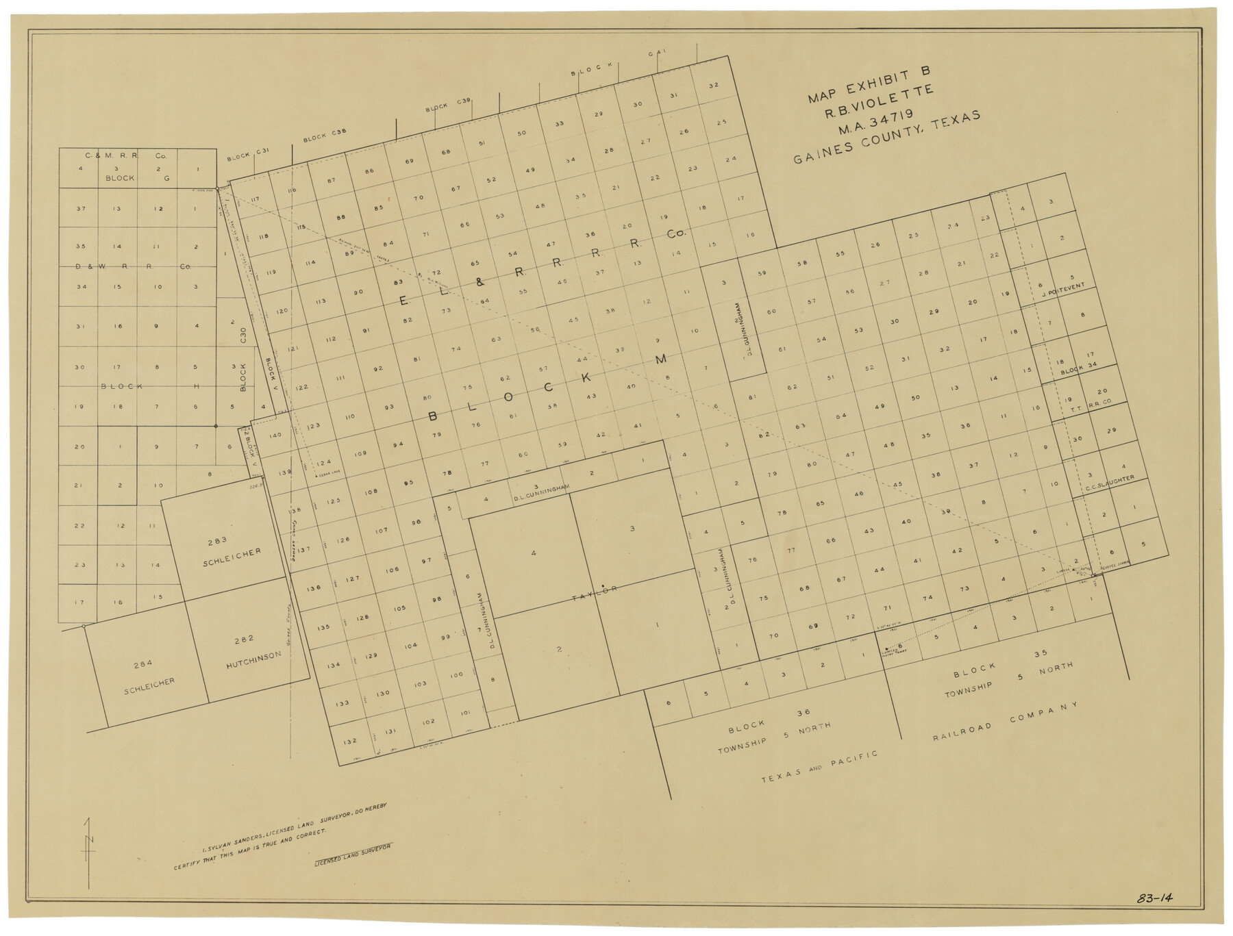
Map Exhibit B, R. B. Violette M. A. 34719, Gaines County, Texas
83-14
-
Map/Doc
90835
-
Collection
Twichell Survey Records
-
People and Organizations
Sylvan Sanders (Surveyor/Engineer)
-
Counties
Gaines
-
Height x Width
30.0 x 23.0 inches
76.2 x 58.4 cm
Part of: Twichell Survey Records
S/L Blk. 42 & H&TC Pt. of W/L[Sketch showing H. & T. C. Blocks 42 and 46]
![91765, S/L Blk. 42 & H&TC Pt. of W/L[Sketch showing H. & T. C. Blocks 42 and 46], Twichell Survey Records](https://historictexasmaps.com/wmedia_w700/maps/91765-1.tif.jpg)
Print $20.00
- Digital $50.00
S/L Blk. 42 & H&TC Pt. of W/L[Sketch showing H. & T. C. Blocks 42 and 46]
Size 35.2 x 19.3 inches
Map/Doc 91765
Subdivision of Midland County School Land, Hockley and Cochran Counties, Texas

Print $20.00
- Digital $50.00
Subdivision of Midland County School Land, Hockley and Cochran Counties, Texas
Size 30.5 x 23.3 inches
Map/Doc 92517
[North Central Part of County]
![90812, [North Central Part of County], Twichell Survey Records](https://historictexasmaps.com/wmedia_w700/maps/90812-2.tif.jpg)
Print $20.00
- Digital $50.00
[North Central Part of County]
1902
Size 21.0 x 28.3 inches
Map/Doc 90812
[Leagues 486-494, 503-539]
![93099, [Leagues 486-494, 503-539], Twichell Survey Records](https://historictexasmaps.com/wmedia_w700/maps/93099-1.tif.jpg)
Print $20.00
- Digital $50.00
[Leagues 486-494, 503-539]
Size 31.8 x 19.9 inches
Map/Doc 93099
Eastern South America Brazil, Paraguay, Uruguay, and the Guianas

Eastern South America Brazil, Paraguay, Uruguay, and the Guianas
1955
Size 29.8 x 41.2 inches
Map/Doc 92389

[Sections 158-162 and surveys to the east]
![93003, [Sections 158-162 and surveys to the east], Twichell Survey Records](https://historictexasmaps.com/wmedia_w700/maps/93003-1.tif.jpg)
Print $20.00
- Digital $50.00
[Sections 158-162 and surveys to the east]
1916
Size 7.8 x 18.9 inches
Map/Doc 93003
[Sketch of surveys in the vicinity of sections 171 and 172 along Pedernales]
![91881, [Sketch of surveys in the vicinity of sections 171 and 172 along Pedernales], Twichell Survey Records](https://historictexasmaps.com/wmedia_w700/maps/91881-1.tif.jpg)
Print $2.00
- Digital $50.00
[Sketch of surveys in the vicinity of sections 171 and 172 along Pedernales]
Size 8.6 x 14.4 inches
Map/Doc 91881
[H. & G. N. Block 28]
![90344, [H. & G. N. Block 28], Twichell Survey Records](https://historictexasmaps.com/wmedia_w700/maps/90344-1.tif.jpg)
Print $20.00
- Digital $50.00
[H. & G. N. Block 28]
Size 25.1 x 31.2 inches
Map/Doc 90344
Plat Showing Land Owned by City of Lubbock out of Section 3, Block O

Print $20.00
- Digital $50.00
Plat Showing Land Owned by City of Lubbock out of Section 3, Block O
Size 40.4 x 31.1 inches
Map/Doc 92876
[Capitol Leagues in Lamb County]
![91014, [Capitol Leagues in Lamb County], Twichell Survey Records](https://historictexasmaps.com/wmedia_w700/maps/91014-1.tif.jpg)
Print $2.00
- Digital $50.00
[Capitol Leagues in Lamb County]
1912
Size 12.7 x 8.8 inches
Map/Doc 91014
J. B. McCauley Irrigated Farm NW Quarter Section 20, Block E

Print $20.00
- Digital $50.00
J. B. McCauley Irrigated Farm NW Quarter Section 20, Block E
1944
Size 20.5 x 23.0 inches
Map/Doc 92334
You may also like
Maps of Gulf Intracoastal Waterway, Texas - Sabine River to the Rio Grande and connecting waterways including ship channels

Print $20.00
- Digital $50.00
Maps of Gulf Intracoastal Waterway, Texas - Sabine River to the Rio Grande and connecting waterways including ship channels
1966
Size 14.5 x 22.3 inches
Map/Doc 61936
Glasscock County Rolled Sketch 6

Print $20.00
- Digital $50.00
Glasscock County Rolled Sketch 6
1946
Size 19.9 x 22.5 inches
Map/Doc 6017
Coast Chart No. 208 - Pass Cavallo, Lavaca and San Antonio Bays, Texas

Print $20.00
- Digital $50.00
Coast Chart No. 208 - Pass Cavallo, Lavaca and San Antonio Bays, Texas
1888
Size 43.9 x 35.7 inches
Map/Doc 73376
Hood County Working Sketch 12

Print $40.00
- Digital $50.00
Hood County Working Sketch 12
1978
Size 25.2 x 55.5 inches
Map/Doc 66206
Presidio County Sketch File S

Print $27.00
- Digital $50.00
Presidio County Sketch File S
1917
Size 14.3 x 8.8 inches
Map/Doc 34561
Report on the Meridional Boundary between Louisiana and Texas, retracement by the Louisiana Geodetic Survey

Print $2.00
- Digital $50.00
Report on the Meridional Boundary between Louisiana and Texas, retracement by the Louisiana Geodetic Survey
Size 11.2 x 8.8 inches
Map/Doc 61174
Montgomery County Rolled Sketch 30

Print $40.00
- Digital $50.00
Montgomery County Rolled Sketch 30
1949
Size 34.6 x 51.3 inches
Map/Doc 9538
Eastland County Working Sketch 10

Print $20.00
- Digital $50.00
Eastland County Working Sketch 10
1919
Size 20.2 x 16.3 inches
Map/Doc 68791
Chart of the Rio Bravo del Norte traced from a survey made by Henry Austin by Lieut. Bowman, 3d. Infy.

Print $20.00
- Digital $50.00
Chart of the Rio Bravo del Norte traced from a survey made by Henry Austin by Lieut. Bowman, 3d. Infy.
1866
Size 18.1 x 27.2 inches
Map/Doc 72890
Calhoun County Sketch File 8

Print $12.00
- Digital $50.00
Calhoun County Sketch File 8
1948
Size 14.2 x 9.0 inches
Map/Doc 35930
Titus County Boundary File 3

Print $6.00
- Digital $50.00
Titus County Boundary File 3
Size 7.6 x 6.9 inches
Map/Doc 59300
Presidio County Sketch File 118

Print $16.00
- Digital $50.00
Presidio County Sketch File 118
Size 14.3 x 8.9 inches
Map/Doc 34919