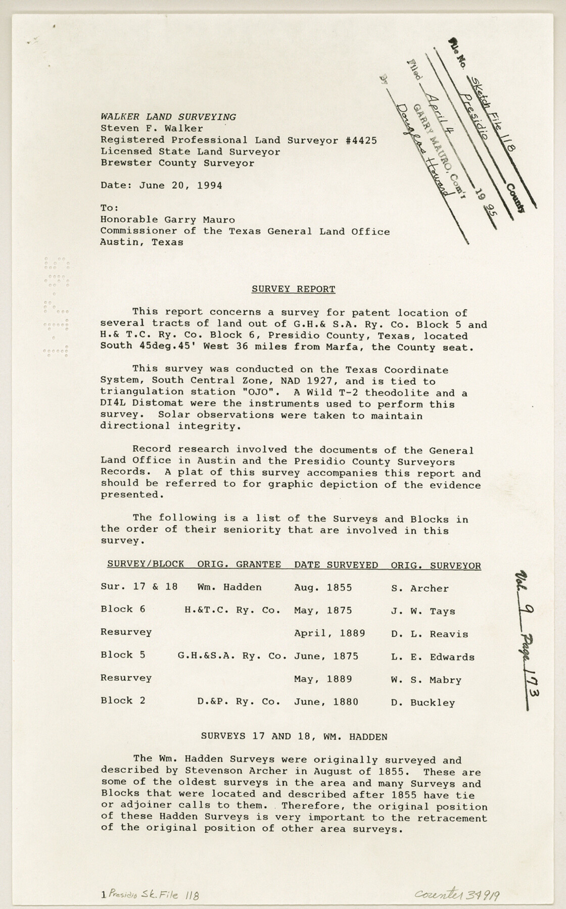
Presidio County Sketch File 118
[Survey report concerning survey for patent location of several tracts of land out of G. H. & S. A. R.R. Co. Block 5 and H. & T. C. R.R. Co. Block 6]
-
Map/Doc
34919
-
Collection
General Map Collection
-
Object Dates
4/4/1995 (File Date)
6/20/1994 (Correspondence Date)
-
People and Organizations
Steven F. Walker (Surveyor/Engineer)
Stevenson Archer (Surveyor/Engineer)
J.W. Tays (Surveyor/Engineer)
D.L. Reavis (Surveyor/Engineer)
L.E. Edwards (Surveyor/Engineer)
W.S. Mabry (Surveyor/Engineer)
Dan Buckley (Surveyor/Engineer)
Malcolm L. Bamburg (Surveyor/Engineer)
R.E. Booker (Surveyor/Engineer)
J.P. Dod (Surveyor/Engineer)
F.W. Cook (Surveyor/Engineer)
W.J. Hurd (Surveyor/Engineer)
William H. Rhoome (Surveyor/Engineer)
-
Counties
Presidio
-
Subjects
Surveying Sketch File
-
Height x Width
14.3 x 8.9 inches
36.3 x 22.6 cm
-
Medium
paper, print
-
Comments
See Presidio County Rolled Sketch 134 (7401) for sketch.
-
Features
Chinati Peak
Related maps
Presidio County Rolled Sketch 134

Print $20.00
- Digital $50.00
Presidio County Rolled Sketch 134
Size 26.6 x 39.6 inches
Map/Doc 7401
Part of: General Map Collection
Moore County Rolled Sketch 11

Print $20.00
- Digital $50.00
Moore County Rolled Sketch 11
Size 34.1 x 43.0 inches
Map/Doc 9549
[Surveys in Austin's Colony along the San Bernardo River, West Bernardo River, and Lone Tree Creek]
![194, [Surveys in Austin's Colony along the San Bernardo River, West Bernardo River, and Lone Tree Creek], General Map Collection](https://historictexasmaps.com/wmedia_w700/maps/194-1.tif.jpg)
Print $20.00
- Digital $50.00
[Surveys in Austin's Colony along the San Bernardo River, West Bernardo River, and Lone Tree Creek]
1830
Size 28.3 x 17.8 inches
Map/Doc 194
Val Verde County Working Sketch 17

Print $20.00
- Digital $50.00
Val Verde County Working Sketch 17
1926
Size 16.5 x 27.8 inches
Map/Doc 72152
Flight Mission No. DQO-8K, Frame 80, Galveston County

Print $20.00
- Digital $50.00
Flight Mission No. DQO-8K, Frame 80, Galveston County
1952
Size 18.8 x 22.5 inches
Map/Doc 85184
Nueces County Rolled Sketch 46

Print $45.00
- Digital $50.00
Nueces County Rolled Sketch 46
Size 10.2 x 15.1 inches
Map/Doc 47859
Terry County Sketch File 19

Print $6.00
- Digital $50.00
Terry County Sketch File 19
1998
Size 11.2 x 8.9 inches
Map/Doc 38047
[Sketch for Mineral Application 26501 - Sabine River, T. A. Oldhausen]
![2834, [Sketch for Mineral Application 26501 - Sabine River, T. A. Oldhausen], General Map Collection](https://historictexasmaps.com/wmedia_w700/maps/2834.tif.jpg)
Print $20.00
- Digital $50.00
[Sketch for Mineral Application 26501 - Sabine River, T. A. Oldhausen]
1931
Size 23.9 x 36.0 inches
Map/Doc 2834
Harris County Working Sketch 75

Print $20.00
- Digital $50.00
Harris County Working Sketch 75
1964
Size 29.7 x 32.3 inches
Map/Doc 65967
Bandera County Working Sketch 18

Print $20.00
- Digital $50.00
Bandera County Working Sketch 18
1946
Size 25.6 x 26.5 inches
Map/Doc 67614
Presidio County Sketch File 37A

Print $18.00
- Digital $50.00
Presidio County Sketch File 37A
Size 11.4 x 8.8 inches
Map/Doc 34499
Edwards County Working Sketch 18

Print $20.00
- Digital $50.00
Edwards County Working Sketch 18
1931
Size 34.3 x 37.0 inches
Map/Doc 68894
Jeff Davis County Sketch File 41

Print $40.00
- Digital $50.00
Jeff Davis County Sketch File 41
1959
Size 13.3 x 13.4 inches
Map/Doc 28064
You may also like
[Surveys in Austin's Colony at Carancahua Bay]
![172, [Surveys in Austin's Colony at Carancahua Bay], General Map Collection](https://historictexasmaps.com/wmedia_w700/maps/172.tif.jpg)
Print $20.00
- Digital $50.00
[Surveys in Austin's Colony at Carancahua Bay]
Size 22.5 x 17.4 inches
Map/Doc 172
Van Zandt County Sketch File 47

Print $7.00
- Digital $50.00
Van Zandt County Sketch File 47
Size 10.0 x 8.1 inches
Map/Doc 39504
Flight Mission No. CRC-2R, Frame 183, Chambers County

Print $20.00
- Digital $50.00
Flight Mission No. CRC-2R, Frame 183, Chambers County
1956
Size 18.7 x 22.3 inches
Map/Doc 84761
Eastland County Working Sketch 1

Print $3.00
- Digital $50.00
Eastland County Working Sketch 1
1907
Size 13.8 x 11.0 inches
Map/Doc 68782
Harris County Working Sketch 3

Print $20.00
- Digital $50.00
Harris County Working Sketch 3
Size 14.7 x 22.4 inches
Map/Doc 65895
Brown County Sketch File 11a

Print $6.00
- Digital $50.00
Brown County Sketch File 11a
1872
Size 6.6 x 3.6 inches
Map/Doc 16599
Flight Mission No. DQN-2K, Frame 144, Calhoun County

Print $20.00
- Digital $50.00
Flight Mission No. DQN-2K, Frame 144, Calhoun County
1953
Size 18.7 x 22.4 inches
Map/Doc 84313

General Highway Map, Hardeman County, Texas

Print $20.00
General Highway Map, Hardeman County, Texas
1961
Size 24.6 x 18.1 inches
Map/Doc 79498
[Coleman County Sections 359, 360, and 361]
![92552, [Coleman County Sections 359, 360, and 361], Twichell Survey Records](https://historictexasmaps.com/wmedia_w700/maps/92552-1.tif.jpg)
Print $20.00
- Digital $50.00
[Coleman County Sections 359, 360, and 361]
1946
Size 17.6 x 22.6 inches
Map/Doc 92552
San Patricio County Rolled Sketch 33

Print $141.00
- Digital $50.00
San Patricio County Rolled Sketch 33
Size 10.2 x 15.0 inches
Map/Doc 48874
Hansford County

Print $20.00
- Digital $50.00
Hansford County
1889
Size 22.9 x 18.5 inches
Map/Doc 3624