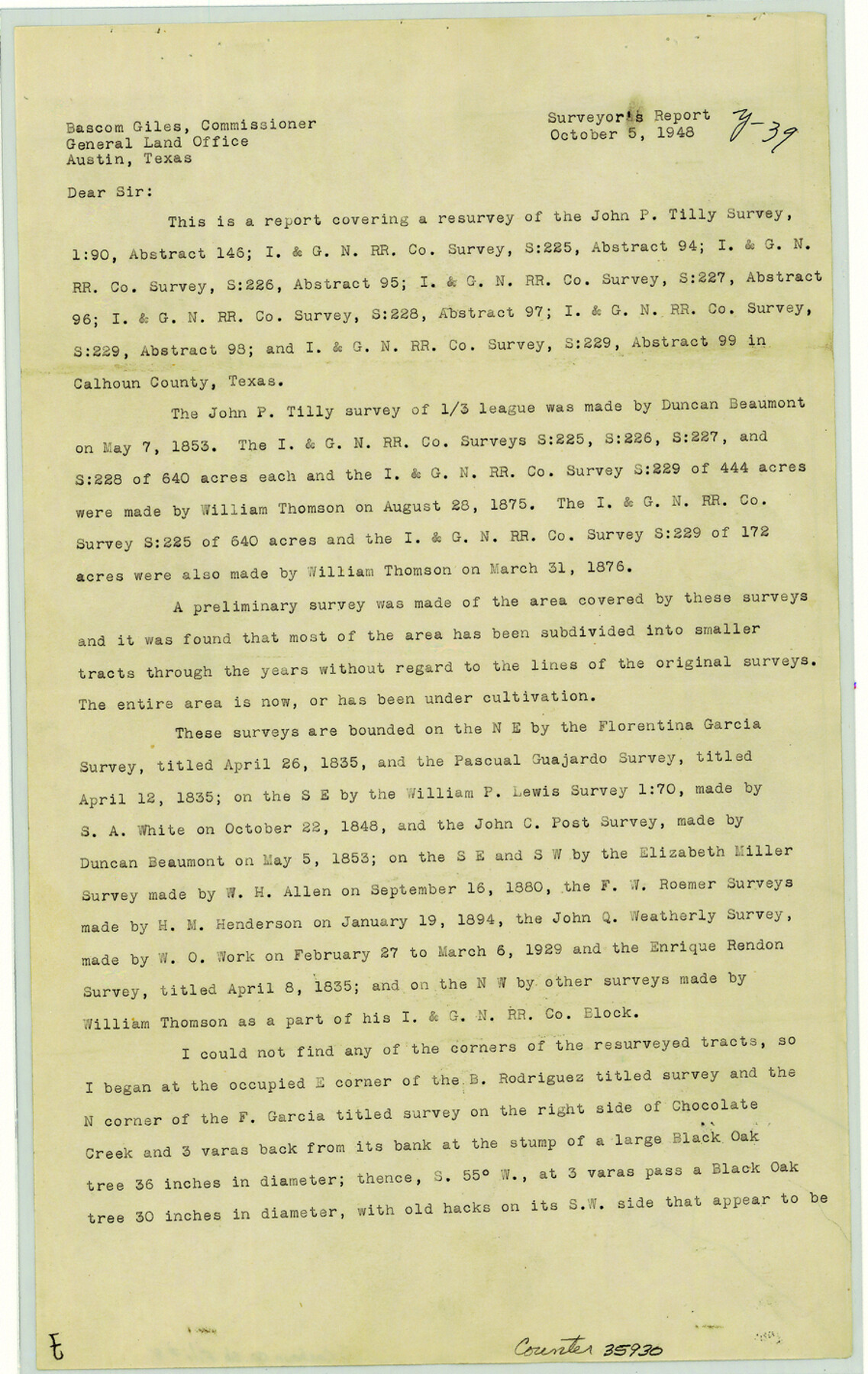
Calhoun County Sketch File 8
[Surveyor's report of a resurvey of John P. Tilly survey and I. & G. N. R.R. Co. surveys adjoining southwest of Port Lavaca]
-
Map/Doc
35930
-
Collection
General Map Collection
-
Object Dates
1948/10/5 (Creation Date)
1948/11/9 (File Date)
-
People and Organizations
Phillip G. Young (Surveyor/Engineer)
-
Counties
Calhoun
-
Subjects
Surveying Sketch File
-
Height x Width
14.2 x 9.0 inches
36.1 x 22.9 cm
-
Medium
paper, print
-
Features
Chocolate Creek
Powderhorn Bayou
Port La Vaca [sic]
Part of: General Map Collection
Lynn County Boundary File 4a

Print $6.00
- Digital $50.00
Lynn County Boundary File 4a
Size 14.3 x 8.8 inches
Map/Doc 56627
Cottle County Working Sketch 1

Print $20.00
- Digital $50.00
Cottle County Working Sketch 1
1895
Size 27.0 x 21.7 inches
Map/Doc 68311
Bailey County Sketch File 14

Print $4.00
- Digital $50.00
Bailey County Sketch File 14
Size 12.2 x 8.7 inches
Map/Doc 13973
Jones County Sketch File 21

Print $56.00
- Digital $50.00
Jones County Sketch File 21
2010
Map/Doc 93292

Roberts County Boundary File 2

Print $12.00
- Digital $50.00
Roberts County Boundary File 2
Size 9.9 x 6.4 inches
Map/Doc 58333
Galveston Bay Entrance - Galveston and Texas City Harbors

Print $40.00
- Digital $50.00
Galveston Bay Entrance - Galveston and Texas City Harbors
1973
Size 37.0 x 53.0 inches
Map/Doc 69863
Val Verde County Sketch File Z6

Print $20.00
- Digital $50.00
Val Verde County Sketch File Z6
Size 29.3 x 26.2 inches
Map/Doc 10425
[Sketch for Mineral Application 27670 - Strip between Simon Sanchez leagues and Trinity River]
![2862, [Sketch for Mineral Application 27670 - Strip between Simon Sanchez leagues and Trinity River], General Map Collection](https://historictexasmaps.com/wmedia_w700/maps/2862-1.tif.jpg)
Print $20.00
- Digital $50.00
[Sketch for Mineral Application 27670 - Strip between Simon Sanchez leagues and Trinity River]
1934
Size 25.7 x 39.9 inches
Map/Doc 2862
Harris County Working Sketch 73

Print $20.00
- Digital $50.00
Harris County Working Sketch 73
1959
Size 33.5 x 38.1 inches
Map/Doc 65965
Denton County Working Sketch 29

Print $40.00
- Digital $50.00
Denton County Working Sketch 29
1987
Size 49.7 x 36.8 inches
Map/Doc 68634

You may also like
Zavala Empresario Colony. March 12, 1829

Print $20.00
Zavala Empresario Colony. March 12, 1829
2020
Size 24.7 x 21.7 inches
Map/Doc 96012
Bowles's New Pocket Map of North America, divided into it's Provinces, Colonies, &c.

Print $20.00
- Digital $50.00
Bowles's New Pocket Map of North America, divided into it's Provinces, Colonies, &c.
1776
Size 21.8 x 29.0 inches
Map/Doc 93732
Galveston County Rolled Sketch 44

Print $20.00
- Digital $50.00
Galveston County Rolled Sketch 44
1991
Size 25.7 x 37.3 inches
Map/Doc 5975
Oldham County

Print $20.00
- Digital $50.00
Oldham County
1888
Size 19.6 x 16.5 inches
Map/Doc 93018
Webb County Rolled Sketch 59

Print $20.00
- Digital $50.00
Webb County Rolled Sketch 59
1947
Size 15.3 x 26.7 inches
Map/Doc 8210
General Highway Map, Randall County, Texas

Print $20.00
General Highway Map, Randall County, Texas
1940
Size 18.3 x 25.0 inches
Map/Doc 79224
Calhoun County Sketch File 6

Print $34.00
- Digital $50.00
Calhoun County Sketch File 6
1942
Size 9.3 x 9.0 inches
Map/Doc 35908

Lampasas County Sketch File 7

Print $4.00
- Digital $50.00
Lampasas County Sketch File 7
1871
Size 8.4 x 8.2 inches
Map/Doc 29402
Falls County Sketch File 25

Print $7.00
- Digital $50.00
Falls County Sketch File 25
1968
Size 10.4 x 8.2 inches
Map/Doc 22430
Flight Mission No. BRA-16M, Frame 180, Jefferson County

Print $20.00
- Digital $50.00
Flight Mission No. BRA-16M, Frame 180, Jefferson County
1953
Size 18.5 x 22.4 inches
Map/Doc 85778
Childress County Sketch File 18a

Print $4.00
- Digital $50.00
Childress County Sketch File 18a
1935
Size 11.3 x 7.1 inches
Map/Doc 18364