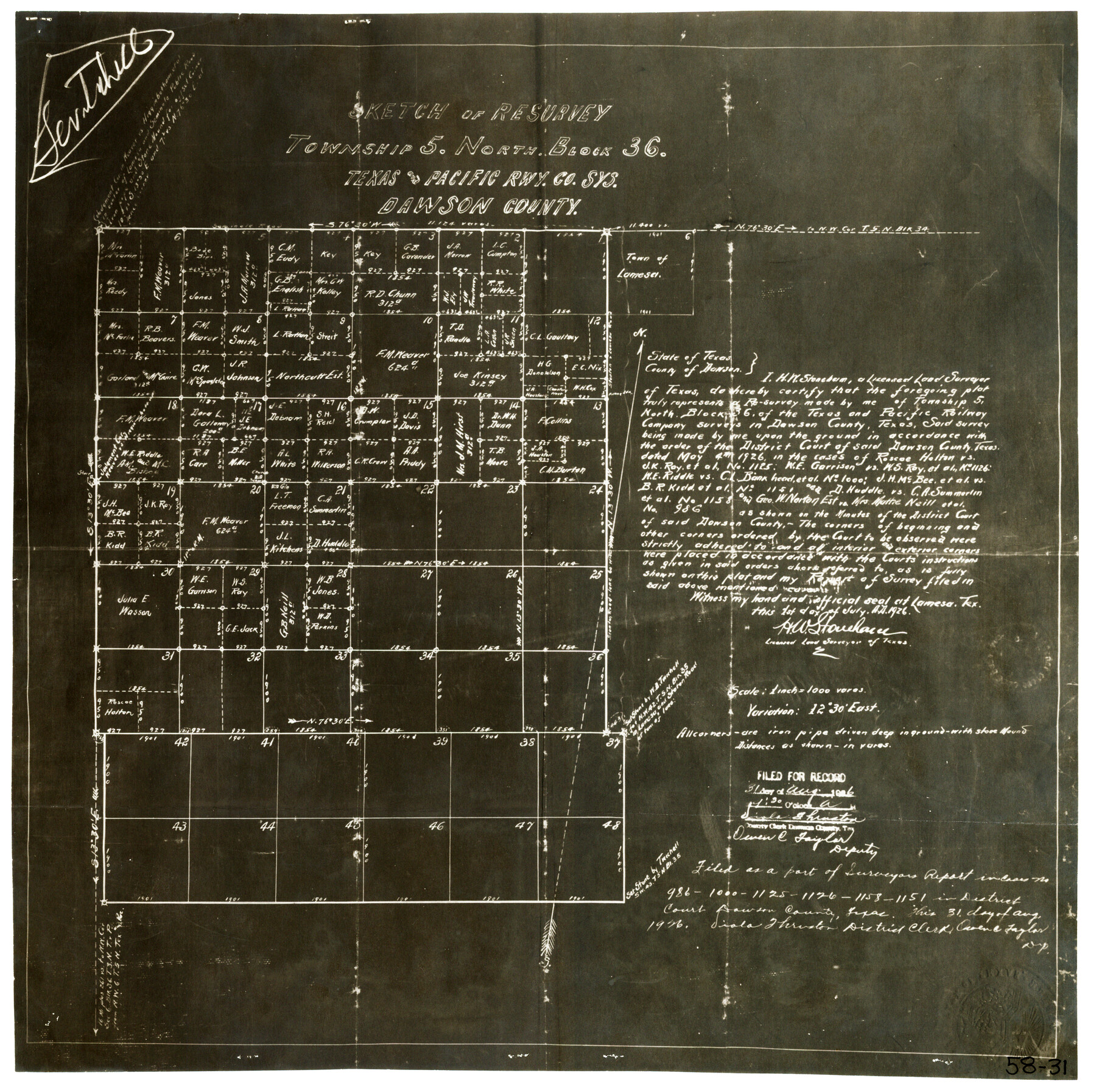
Sketch of Resurvey Township 5 North Block 36, Texas and Pacific Rwy. Co. Sys. Dawson County
58-31
-
Map/Doc
90544
-
Collection
Twichell Survey Records
-
Object Dates
7/1/1926 (Creation Date)
-
People and Organizations
H.W. Stoneham (Surveyor/Engineer)
-
Counties
Dawson
-
Height x Width
12.1 x 12.0 inches
30.7 x 30.5 cm
Part of: Twichell Survey Records
Town of Ropes Hockley County, Texas

Print $20.00
- Digital $50.00
Town of Ropes Hockley County, Texas
Size 29.5 x 29.8 inches
Map/Doc 92223

General Highway Map Moore County

Print $3.00
- Digital $50.00
General Highway Map Moore County
Size 14.4 x 10.3 inches
Map/Doc 92289

[PSL Blocks A, 38, 40, 51-57, B-1 and C and T. & P. Block 46, Township 1N]
![93149, [PSL Blocks A, 38, 40, 51-57, B-1 and C and T. & P. Block 46, Township 1N], Twichell Survey Records](https://historictexasmaps.com/wmedia_w700/maps/93149-1.tif.jpg)
Print $40.00
- Digital $50.00
[PSL Blocks A, 38, 40, 51-57, B-1 and C and T. & P. Block 46, Township 1N]
Size 23.8 x 84.4 inches
Map/Doc 93149

[John S. Stephens Blk. S2, Lgs. 174-177, 186-193, 201-209]
![89984, [John S. Stephens Blk. S2, Lgs. 174-177, 186-193, 201-209], Twichell Survey Records](https://historictexasmaps.com/wmedia_w700/maps/89984-1.tif.jpg)
Print $2.00
- Digital $50.00
[John S. Stephens Blk. S2, Lgs. 174-177, 186-193, 201-209]
1912
Size 11.4 x 8.8 inches
Map/Doc 89984
Block D14 Terry County

Print $20.00
- Digital $50.00
Block D14 Terry County
Size 17.0 x 17.7 inches
Map/Doc 92416
Public School Land Leagues 1 through 63]
![92487, Public School Land Leagues 1 through 63], Twichell Survey Records](https://historictexasmaps.com/wmedia_w700/maps/92487-1.tif.jpg)
Print $20.00
- Digital $50.00
Public School Land Leagues 1 through 63]
Size 23.9 x 16.8 inches
Map/Doc 92487
[Block C-41, Section 37, Dawson County, Texas]
![92629, [Block C-41, Section 37, Dawson County, Texas], Twichell Survey Records](https://historictexasmaps.com/wmedia_w700/maps/92629-1.tif.jpg)
Print $20.00
- Digital $50.00
[Block C-41, Section 37, Dawson County, Texas]
1950
Size 14.3 x 12.6 inches
Map/Doc 92629
Map Showing a Resurvey of Part of Blk. I, H. &. G. N. Ry. Co. Pecos County, Texas, following field notes copied from Jacob Kuechler's field book of his original survey made in October and November 1876

Print $20.00
- Digital $50.00
Map Showing a Resurvey of Part of Blk. I, H. &. G. N. Ry. Co. Pecos County, Texas, following field notes copied from Jacob Kuechler's field book of his original survey made in October and November 1876
1930
Size 19.7 x 14.8 inches
Map/Doc 91571
Revised Map of Pendleton-Baxter-Addition to Shamrock Located on N.E. 1/4 Section 37, Block 17 H. & G.N.RR.Co., Wheeler County, Texas

Print $20.00
- Digital $50.00
Revised Map of Pendleton-Baxter-Addition to Shamrock Located on N.E. 1/4 Section 37, Block 17 H. & G.N.RR.Co., Wheeler County, Texas
Size 16.7 x 18.8 inches
Map/Doc 92123
You may also like
Presidio County Rolled Sketch 131B

Print $20.00
- Digital $50.00
Presidio County Rolled Sketch 131B
1993
Size 33.4 x 46.7 inches
Map/Doc 9803
[G. & M. Block 5]
![91793, [G. & M. Block 5], Twichell Survey Records](https://historictexasmaps.com/wmedia_w700/maps/91793-1.tif.jpg)
Print $20.00
- Digital $50.00
[G. & M. Block 5]
Size 34.9 x 17.2 inches
Map/Doc 91793
Nueces County NRC Article 33.136 Sketch 3

Print $68.00
- Digital $50.00
Nueces County NRC Article 33.136 Sketch 3
2002
Size 24.7 x 36.5 inches
Map/Doc 87922
Hardin County Rolled Sketch WS

Print $20.00
- Digital $50.00
Hardin County Rolled Sketch WS
1936
Size 25.4 x 43.9 inches
Map/Doc 9104
Brewster County Working Sketch 107

Print $20.00
- Digital $50.00
Brewster County Working Sketch 107
1981
Size 34.7 x 37.1 inches
Map/Doc 67707
Crosby County Sketch File 2

Print $22.00
- Digital $50.00
Crosby County Sketch File 2
Size 8.5 x 9.9 inches
Map/Doc 19991
Stonewall County Boundary File 4a

Print $18.00
- Digital $50.00
Stonewall County Boundary File 4a
Size 14.2 x 8.8 inches
Map/Doc 58984
Hutchinson County Rolled Sketch 23

Print $20.00
- Digital $50.00
Hutchinson County Rolled Sketch 23
1913
Size 29.7 x 25.6 inches
Map/Doc 6288
Starr County Sketch File 9

Print $22.00
- Digital $50.00
Starr County Sketch File 9
Size 9.1 x 7.9 inches
Map/Doc 36861
[Blocks JK, JK4, JD, A1, and A2]
![90748, [Blocks JK, JK4, JD, A1, and A2], Twichell Survey Records](https://historictexasmaps.com/wmedia_w700/maps/90748-1.tif.jpg)
Print $20.00
- Digital $50.00
[Blocks JK, JK4, JD, A1, and A2]
Size 12.5 x 28.8 inches
Map/Doc 90748
Duval County Rolled Sketch 19

Print $4.00
- Digital $50.00
Duval County Rolled Sketch 19
1940
Size 20.2 x 15.1 inches
Map/Doc 5740
Part of Laguna Madre in Nueces and Kleberg Counties, showing Subdivision for Mineral Development

Print $20.00
- Digital $50.00
Part of Laguna Madre in Nueces and Kleberg Counties, showing Subdivision for Mineral Development
1948
Size 42.0 x 30.3 inches
Map/Doc 1921