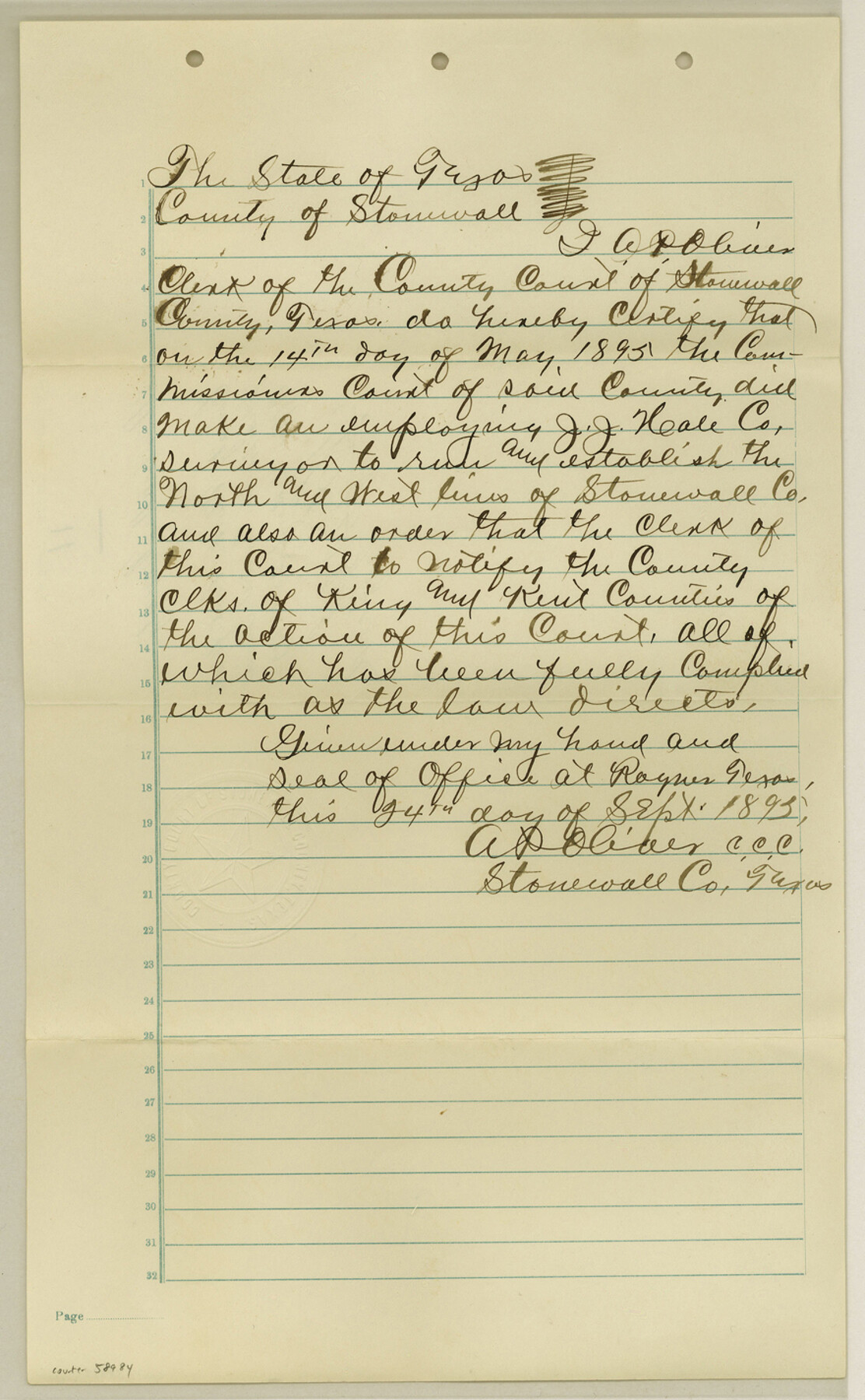
Stonewall County Boundary File 4a
Letter of explanation; Copy of the order of the County Commissioners Court; Surveyor's Certificate; County Clerk's Certificate
-
Map/Doc
58984
-
Collection
General Map Collection
-
Counties
Stonewall
-
Subjects
County Boundaries
-
Height x Width
14.2 x 8.8 inches
36.1 x 22.4 cm
Part of: General Map Collection
Shackelford County

Print $20.00
- Digital $50.00
Shackelford County
1920
Size 44.6 x 37.1 inches
Map/Doc 16813
Gregg County Rolled Sketch 20

Print $20.00
- Digital $50.00
Gregg County Rolled Sketch 20
1957
Size 34.6 x 44.7 inches
Map/Doc 6478
Harris County Sketch File H

Print $4.00
- Digital $50.00
Harris County Sketch File H
1860
Size 8.2 x 5.5 inches
Map/Doc 25321
Angelina County Working Sketch 32b

Print $20.00
- Digital $50.00
Angelina County Working Sketch 32b
1955
Size 23.0 x 28.6 inches
Map/Doc 67115
Duval County Sketch File 15

Print $4.00
- Digital $50.00
Duval County Sketch File 15
Size 12.0 x 9.0 inches
Map/Doc 21309
Loving County Rolled Sketch 2

Print $40.00
- Digital $50.00
Loving County Rolled Sketch 2
1952
Size 42.4 x 70.4 inches
Map/Doc 9462
Galveston County NRC Article 33.136 Sketch 45

Print $21.00
- Digital $50.00
Galveston County NRC Article 33.136 Sketch 45
2007
Size 18.7 x 23.4 inches
Map/Doc 87365
Zapata County Sketch File 13a

Print $20.00
- Digital $50.00
Zapata County Sketch File 13a
1935
Size 21.4 x 16.0 inches
Map/Doc 12722
Upshur County Working Sketch 4

Print $20.00
- Digital $50.00
Upshur County Working Sketch 4
1939
Size 21.6 x 15.3 inches
Map/Doc 69560
Ochiltree County State of Texas

Print $20.00
- Digital $50.00
Ochiltree County State of Texas
1889
Size 25.5 x 19.0 inches
Map/Doc 4609
Kenedy County Sketch File 2

Print $130.00
- Digital $50.00
Kenedy County Sketch File 2
1995
Size 11.2 x 8.7 inches
Map/Doc 28773
Map of Dickens County

Print $20.00
- Digital $50.00
Map of Dickens County
1899
Size 41.1 x 37.7 inches
Map/Doc 4933
You may also like
No. 2 Chart of Corpus Christi Pass, Texas

Print $20.00
- Digital $50.00
No. 2 Chart of Corpus Christi Pass, Texas
1878
Size 18.4 x 27.5 inches
Map/Doc 73023
Harris County Rolled Sketch 97

Print $20.00
- Digital $50.00
Harris County Rolled Sketch 97
Size 18.8 x 23.6 inches
Map/Doc 6135
[Surveys in the Travis District along the Colorado River]
![118, [Surveys in the Travis District along the Colorado River], General Map Collection](https://historictexasmaps.com/wmedia_w700/maps/118.tif.jpg)
Print $2.00
- Digital $50.00
[Surveys in the Travis District along the Colorado River]
1841
Size 8.6 x 15.3 inches
Map/Doc 118
San Patricio County Rolled Sketch 46N

Print $3.00
- Digital $50.00
San Patricio County Rolled Sketch 46N
1983
Size 12.2 x 9.3 inches
Map/Doc 8385

Nueces County Rolled Sketch 19

Print $20.00
- Digital $50.00
Nueces County Rolled Sketch 19
1920
Size 22.5 x 32.7 inches
Map/Doc 6872
Webb County Rolled Sketch 14

Print $20.00
- Digital $50.00
Webb County Rolled Sketch 14
1915
Size 12.6 x 28.5 inches
Map/Doc 8178
Fort Bend County

Print $20.00
- Digital $50.00
Fort Bend County
1892
Size 29.3 x 25.7 inches
Map/Doc 3551
Reeves County

Print $40.00
- Digital $50.00
Reeves County
1903
Size 48.7 x 36.5 inches
Map/Doc 16798
[Part of T. & N. O. RR. Co Block 2 and area around Jasper Hays survey]
![90850, [Part of T. & N. O. RR. Co Block 2 and area around Jasper Hays survey], Twichell Survey Records](https://historictexasmaps.com/wmedia_w700/maps/90850-2.tif.jpg)
Print $20.00
- Digital $50.00
[Part of T. & N. O. RR. Co Block 2 and area around Jasper Hays survey]
1907
Size 13.3 x 28.4 inches
Map/Doc 90850
San Antonio, Texas - The Great Winter Resort of the South

San Antonio, Texas - The Great Winter Resort of the South
1930
Size 6.6 x 3.5 inches
Map/Doc 97046
Deaf Smith County Rolled Sketch 2

Print $20.00
- Digital $50.00
Deaf Smith County Rolled Sketch 2
1976
Size 42.7 x 14.4 inches
Map/Doc 5699