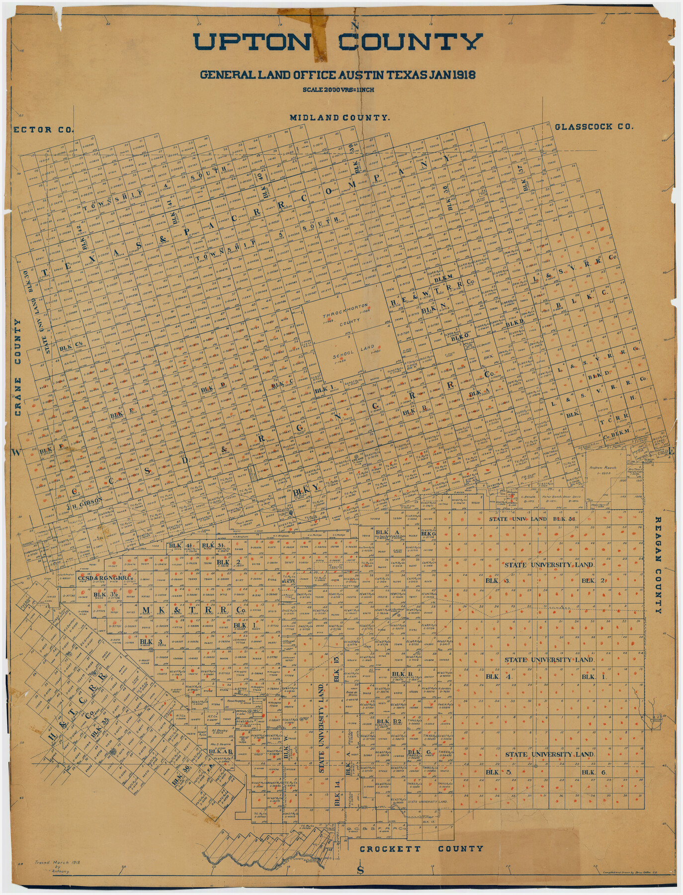
Upton County
-
Map/Doc
89891
-
Collection
Twichell Survey Records
-
Object Dates
1/1918 (Creation Date)
-
People and Organizations
Tom Atlee (Draftsman)
Tom Atlee (Compiler)
-
Counties
Upton
-
Subjects
County
-
Height x Width
42.1 x 54.8 inches
106.9 x 139.2 cm
Part of: Twichell Survey Records
[Part of Blocks 34 and 35, Township 3 North]
![91287, [Part of Blocks 34 and 35, Township 3 North], Twichell Survey Records](https://historictexasmaps.com/wmedia_w700/maps/91287-1.tif.jpg)
Print $20.00
- Digital $50.00
[Part of Blocks 34 and 35, Township 3 North]
Size 12.7 x 13.5 inches
Map/Doc 91287
Martin County Sketch

Print $20.00
- Digital $50.00
Martin County Sketch
1924
Size 14.3 x 17.2 inches
Map/Doc 92269
[Sketch showing B. S. & F. Block 9 and vicinity]
![89786, [Sketch showing B. S. & F. Block 9 and vicinity], Twichell Survey Records](https://historictexasmaps.com/wmedia_w700/maps/89786-1.tif.jpg)
Print $20.00
- Digital $50.00
[Sketch showing B. S. & F. Block 9 and vicinity]
Size 39.0 x 47.6 inches
Map/Doc 89786
Working Sketch in Stephens-Palo Pinto Cos.

Print $20.00
- Digital $50.00
Working Sketch in Stephens-Palo Pinto Cos.
1919
Size 21.7 x 13.2 inches
Map/Doc 91887
[Panhandle Counties]
![89951, [Panhandle Counties], Twichell Survey Records](https://historictexasmaps.com/wmedia_w700/maps/89951-1.tif.jpg)
Print $20.00
- Digital $50.00
[Panhandle Counties]
Size 41.8 x 43.2 inches
Map/Doc 89951
Sketch of Roll Number for Copy of Original Field Notes Texas & Pacific Railway Reservation

Print $3.00
- Digital $50.00
Sketch of Roll Number for Copy of Original Field Notes Texas & Pacific Railway Reservation
Size 17.4 x 10.0 inches
Map/Doc 92026
[Map showing State Capitol Lands]
![93143, [Map showing State Capitol Lands], Twichell Survey Records](https://historictexasmaps.com/wmedia_w700/maps/93143-1.tif.jpg)
Print $40.00
- Digital $50.00
[Map showing State Capitol Lands]
Size 50.6 x 65.3 inches
Map/Doc 93143
[Blocks C31, C32, C36-C39]
![91867, [Blocks C31, C32, C36-C39], Twichell Survey Records](https://historictexasmaps.com/wmedia_w700/maps/91867-1.tif.jpg)
Print $20.00
- Digital $50.00
[Blocks C31, C32, C36-C39]
Size 15.6 x 16.0 inches
Map/Doc 91867
[PSL Block B1 and T. & P. Blocks 45 and 46, Township 1N]
![91967, [PSL Block B1 and T. & P. Blocks 45 and 46, Township 1N], Twichell Survey Records](https://historictexasmaps.com/wmedia_w700/maps/91967-1.tif.jpg)
Print $20.00
- Digital $50.00
[PSL Block B1 and T. & P. Blocks 45 and 46, Township 1N]
Size 40.8 x 10.6 inches
Map/Doc 91967
[Surveys just south of Runnels County School Land Survey No. 3]
![91552, [Surveys just south of Runnels County School Land Survey No. 3], Twichell Survey Records](https://historictexasmaps.com/wmedia_w700/maps/91552-1.tif.jpg)
Print $20.00
- Digital $50.00
[Surveys just south of Runnels County School Land Survey No. 3]
1926
Size 19.4 x 13.1 inches
Map/Doc 91552
[Subdivision plat of Crockett County School Land Leagues 214-217 and adjacent leagues]
![90245, [Subdivision plat of Crockett County School Land Leagues 214-217 and adjacent leagues], Twichell Survey Records](https://historictexasmaps.com/wmedia_w700/maps/90245-1.tif.jpg)
Print $20.00
- Digital $50.00
[Subdivision plat of Crockett County School Land Leagues 214-217 and adjacent leagues]
Size 26.8 x 18.8 inches
Map/Doc 90245
[H. & T. C. Block 47 and Vicinity]
![91423, [H. & T. C. Block 47 and Vicinity], Twichell Survey Records](https://historictexasmaps.com/wmedia_w700/maps/91423-1.tif.jpg)
Print $20.00
- Digital $50.00
[H. & T. C. Block 47 and Vicinity]
1887
Size 16.3 x 18.8 inches
Map/Doc 91423
You may also like
Flight Mission No. CRE-1R, Frame 197, Jackson County

Print $20.00
- Digital $50.00
Flight Mission No. CRE-1R, Frame 197, Jackson County
1956
Size 18.5 x 22.4 inches
Map/Doc 85351
Atascosa County Working Sketch 1a

Print $20.00
- Digital $50.00
Atascosa County Working Sketch 1a
1908
Size 35.8 x 40.2 inches
Map/Doc 67194
[E.L.R.R.R.R.Co. Blocks A-1, 1, H, Y, Public School Land Blocks C-40, C-41, C-39, C-42]
![92904, [E.L.R.R.R.R.Co. Blocks A-1, 1, H, Y, Public School Land Blocks C-40, C-41, C-39, C-42], Twichell Survey Records](https://historictexasmaps.com/wmedia_w700/maps/92904-1.tif.jpg)
Print $20.00
- Digital $50.00
[E.L.R.R.R.R.Co. Blocks A-1, 1, H, Y, Public School Land Blocks C-40, C-41, C-39, C-42]
Size 21.6 x 21.2 inches
Map/Doc 92904
Kent County Working Sketch 10

Print $20.00
- Digital $50.00
Kent County Working Sketch 10
Size 34.1 x 43.0 inches
Map/Doc 70017
Gonzales County Rolled Sketch 3

Print $20.00
- Digital $50.00
Gonzales County Rolled Sketch 3
2021
Size 24.4 x 35.6 inches
Map/Doc 96582
[Sabine County School Land and Blocks A4, W, and DT]
![92697, [Sabine County School Land and Blocks A4, W, and DT], Twichell Survey Records](https://historictexasmaps.com/wmedia_w700/maps/92697-1.tif.jpg)
Print $20.00
- Digital $50.00
[Sabine County School Land and Blocks A4, W, and DT]
Size 18.9 x 15.6 inches
Map/Doc 92697
Map of Kimble County

Print $20.00
- Digital $50.00
Map of Kimble County
1878
Size 19.7 x 29.0 inches
Map/Doc 3766
[H. & G. N. Blocks 1-4 and Blocks C-19, C-20, 54, 55 and 56]
![91781, [H. & G. N. Blocks 1-4 and Blocks C-19, C-20, 54, 55 and 56], Twichell Survey Records](https://historictexasmaps.com/wmedia_w700/maps/91781-1.tif.jpg)
Print $20.00
- Digital $50.00
[H. & G. N. Blocks 1-4 and Blocks C-19, C-20, 54, 55 and 56]
Size 23.3 x 29.3 inches
Map/Doc 91781
Reagan County Rolled Sketch 21

Print $20.00
- Digital $50.00
Reagan County Rolled Sketch 21
1950
Size 32.5 x 42.2 inches
Map/Doc 9815
Frio County Rolled Sketch 22

Print $20.00
- Digital $50.00
Frio County Rolled Sketch 22
1962
Size 16.4 x 24.6 inches
Map/Doc 5923
Kinney County Working Sketch 34

Print $20.00
- Digital $50.00
Kinney County Working Sketch 34
1963
Size 23.0 x 26.9 inches
Map/Doc 70216
Donley County Boundary File 1

Print $12.00
- Digital $50.00
Donley County Boundary File 1
Size 11.1 x 8.6 inches
Map/Doc 52613