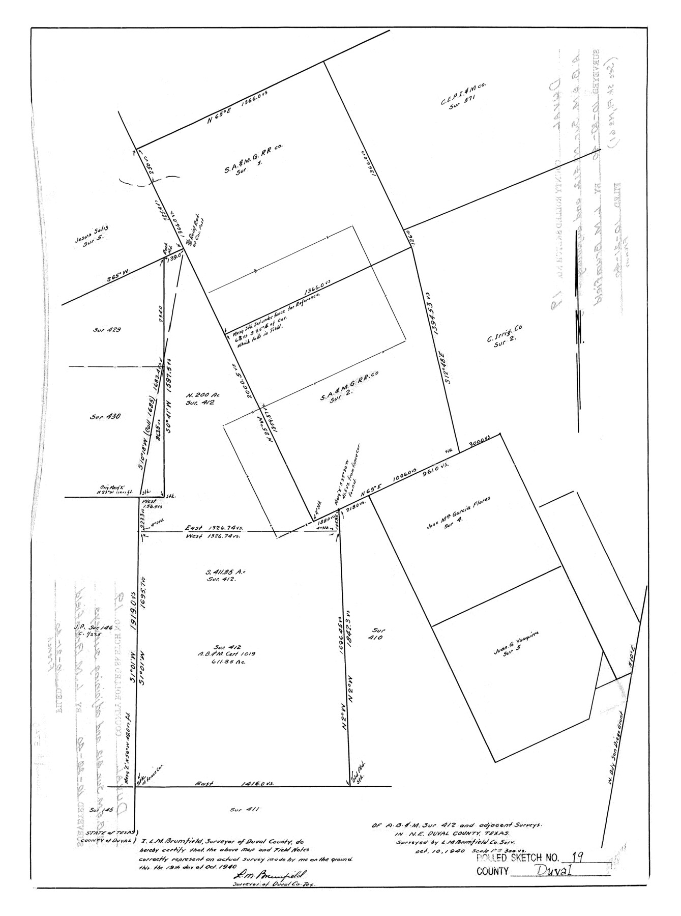
Duval County Rolled Sketch 19
[Sketch] of A. B. & M. sur. 412 and adjacent surveys in NE Duval County, Texas
-
Map/Doc
5740
-
Collection
General Map Collection
-
Object Dates
1940/10/19 (Creation Date)
1940/10/21 (File Date)
-
People and Organizations
L.M. Brumfield (Surveyor/Engineer)
-
Counties
Duval
-
Subjects
Surveying Rolled Sketch
-
Height x Width
20.2 x 15.1 inches
51.3 x 38.4 cm
-
Scale
1" = 300 varas
Part of: General Map Collection
Culberson County Rolled Sketch 63

Print $20.00
- Digital $50.00
Culberson County Rolled Sketch 63
1986
Size 19.4 x 24.3 inches
Map/Doc 5679

Upton County Rolled Sketch 48

Print $20.00
- Digital $50.00
Upton County Rolled Sketch 48
1958
Size 27.8 x 27.9 inches
Map/Doc 10694
Fractional Township No. 10 South Range No. 9 East of the Indian Meridian, Indian Territory

Print $20.00
- Digital $50.00
Fractional Township No. 10 South Range No. 9 East of the Indian Meridian, Indian Territory
1898
Size 19.3 x 24.4 inches
Map/Doc 75217
Calhoun County Rolled Sketch 14

Print $20.00
- Digital $50.00
Calhoun County Rolled Sketch 14
Size 22.3 x 40.8 inches
Map/Doc 5456
Willacy County Boundary File 2

Print $16.00
- Digital $50.00
Willacy County Boundary File 2
Size 11.0 x 8.7 inches
Map/Doc 59967
Upshur County Working Sketch 5

Print $20.00
- Digital $50.00
Upshur County Working Sketch 5
1941
Size 15.0 x 20.6 inches
Map/Doc 69561
Brazoria County Working Sketch 48

Print $20.00
- Digital $50.00
Brazoria County Working Sketch 48
1990
Size 25.2 x 29.5 inches
Map/Doc 67533
Goliad County Working Sketch 3

Print $40.00
- Digital $50.00
Goliad County Working Sketch 3
1916
Size 42.8 x 76.4 inches
Map/Doc 63193
Township 10 South Range 13 West, South Western District, Louisiana

Print $20.00
- Digital $50.00
Township 10 South Range 13 West, South Western District, Louisiana
1876
Size 19.5 x 24.6 inches
Map/Doc 65853
Limestone County Sketch File 26

Print $12.00
- Digital $50.00
Limestone County Sketch File 26
Size 14.3 x 8.7 inches
Map/Doc 30210
Brewster County Rolled Sketch 82

Print $20.00
- Digital $50.00
Brewster County Rolled Sketch 82
1945
Size 20.3 x 23.3 inches
Map/Doc 5245
You may also like
Map of the Survey of the Parallel 36 1/2 Degrees North Latitude, Commencing at the 100th and Running to the 103rd Degree of Longitude West of Greenwich

Print $40.00
- Digital $50.00
Map of the Survey of the Parallel 36 1/2 Degrees North Latitude, Commencing at the 100th and Running to the 103rd Degree of Longitude West of Greenwich
1862
Size 115.6 x 14.9 inches
Map/Doc 73566
Plat showing proposed Water Permit on Cow Bayou in Orange County, Texas

Print $20.00
- Digital $50.00
Plat showing proposed Water Permit on Cow Bayou in Orange County, Texas
1922
Size 24.3 x 16.4 inches
Map/Doc 93017
Jackson County Sketch File 8

Print $20.00
- Digital $50.00
Jackson County Sketch File 8
Size 30.5 x 35.7 inches
Map/Doc 10503
Walker County Working Sketch 1

Print $20.00
- Digital $50.00
Walker County Working Sketch 1
1912
Size 20.1 x 18.4 inches
Map/Doc 72281
Zavala County Sketch File 40

Print $20.00
- Digital $50.00
Zavala County Sketch File 40
1901
Size 14.4 x 8.9 inches
Map/Doc 41406
Starr County Working Sketch 19

Print $20.00
- Digital $50.00
Starr County Working Sketch 19
1982
Size 27.3 x 33.9 inches
Map/Doc 63935
Bastrop County Rolled Sketch 1

Print $20.00
- Digital $50.00
Bastrop County Rolled Sketch 1
Size 30.0 x 23.9 inches
Map/Doc 5121
[Anderson County]
![5051, [Anderson County], General Map Collection](https://historictexasmaps.com/wmedia_w700/maps/5051-GC.tif.jpg)
Print $20.00
- Digital $50.00
[Anderson County]
1848
Size 26.0 x 19.9 inches
Map/Doc 5051
Ochiltree County Working Sketch 1

Print $20.00
- Digital $50.00
Ochiltree County Working Sketch 1
1954
Size 16.7 x 11.6 inches
Map/Doc 71314
Flight Mission No. CRC-3R, Frame 211, Chambers County

Print $20.00
- Digital $50.00
Flight Mission No. CRC-3R, Frame 211, Chambers County
1956
Size 18.6 x 22.2 inches
Map/Doc 84866
Calhoun County Sketch File 19

Print $70.00
- Digital $50.00
Calhoun County Sketch File 19
1998
Size 11.1 x 8.1 inches
Map/Doc 35992
La Salle County Sketch File 7

Print $22.00
- Digital $50.00
La Salle County Sketch File 7
Size 8.0 x 12.3 inches
Map/Doc 29456