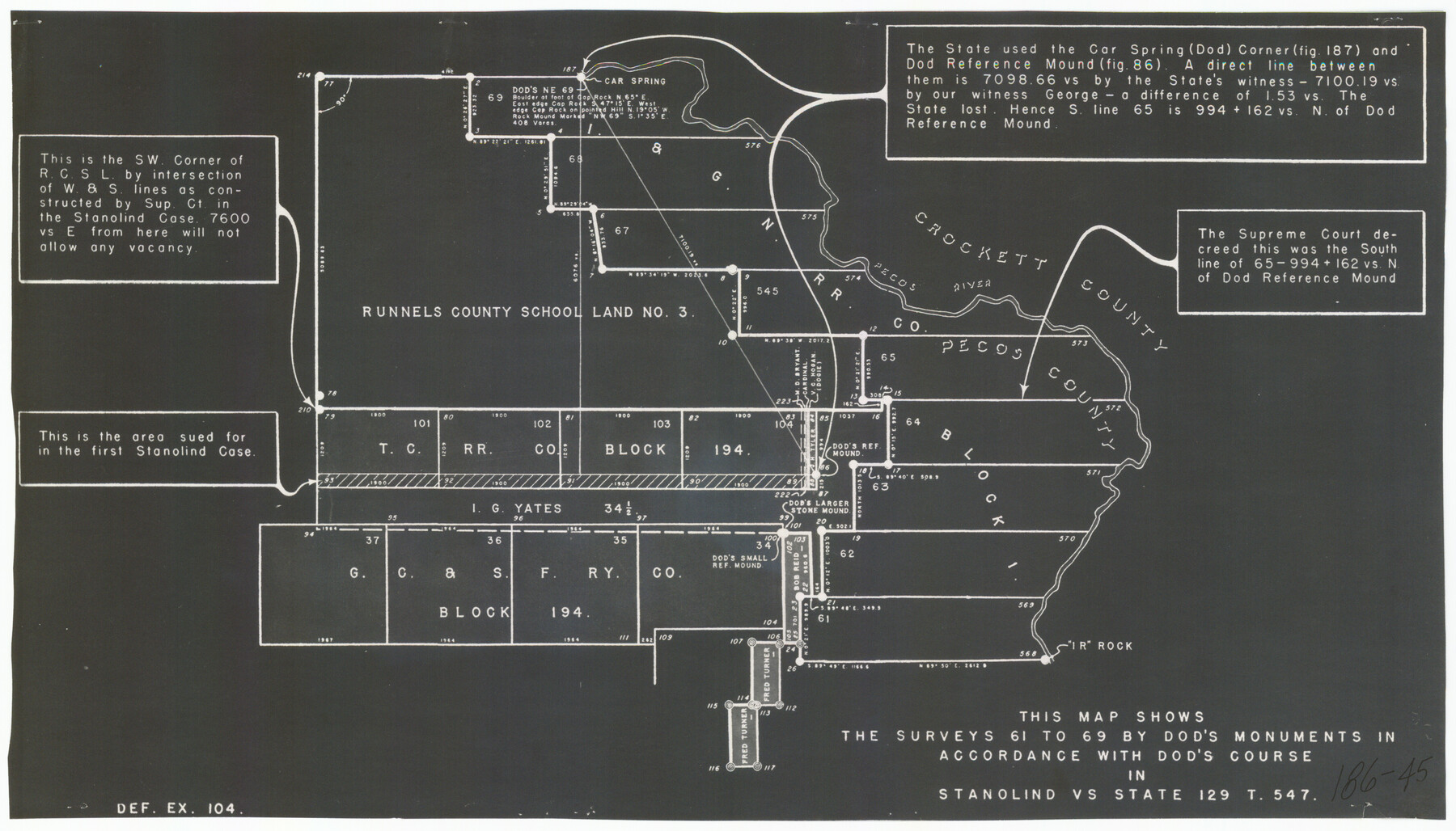
This Map Shows the Surveys 61 to 69 by Dod's Monuments in Accordance with Dod's Course in Stanolind vs. State
186-45
-
Map/Doc
91687
-
Collection
Twichell Survey Records
-
Counties
Pecos
-
Height x Width
15.7 x 9.0 inches
39.9 x 22.9 cm
Part of: Twichell Survey Records
[R. T. Bucy's Survey 3, League 321]
![91295, [R. T. Bucy's Survey 3, League 321], Twichell Survey Records](https://historictexasmaps.com/wmedia_w700/maps/91295-1.tif.jpg)
Print $20.00
- Digital $50.00
[R. T. Bucy's Survey 3, League 321]
Size 12.2 x 18.7 inches
Map/Doc 91295
Seagraves, Gaines County, Texas, Located in Surveys 10 and 15, Block C-34

Print $20.00
- Digital $50.00
Seagraves, Gaines County, Texas, Located in Surveys 10 and 15, Block C-34
Size 33.3 x 23.8 inches
Map/Doc 92687
[School Leagues 245-260, 320-322, 325]
![91342, [School Leagues 245-260, 320-322, 325], Twichell Survey Records](https://historictexasmaps.com/wmedia_w700/maps/91342-1.tif.jpg)
Print $20.00
- Digital $50.00
[School Leagues 245-260, 320-322, 325]
Size 23.3 x 41.4 inches
Map/Doc 91342
Ellwood Place, Installment No. 3

Print $20.00
- Digital $50.00
Ellwood Place, Installment No. 3
Size 17.8 x 24.9 inches
Map/Doc 92791
[Garza County School Land and Vicinity]
![91294, [Garza County School Land and Vicinity], Twichell Survey Records](https://historictexasmaps.com/wmedia_w700/maps/91294-1.tif.jpg)
Print $3.00
- Digital $50.00
[Garza County School Land and Vicinity]
Size 13.4 x 11.9 inches
Map/Doc 91294
Official Map, City of Lubbock, Lubbock County, Texas

Print $20.00
- Digital $50.00
Official Map, City of Lubbock, Lubbock County, Texas
1927
Size 24.1 x 32.9 inches
Map/Doc 91329
[Eastern Texas RR. Co. Block 1]
![91922, [Eastern Texas RR. Co. Block 1], Twichell Survey Records](https://historictexasmaps.com/wmedia_w700/maps/91922-1.tif.jpg)
Print $20.00
- Digital $50.00
[Eastern Texas RR. Co. Block 1]
Size 34.7 x 31.0 inches
Map/Doc 91922
[Texas and Pacific Railway Company, Block 44, Township One South]
![89845, [Texas and Pacific Railway Company, Block 44, Township One South], Twichell Survey Records](https://historictexasmaps.com/wmedia_w700/maps/89845-1.tif.jpg)
Print $40.00
- Digital $50.00
[Texas and Pacific Railway Company, Block 44, Township One South]
Size 42.0 x 59.2 inches
Map/Doc 89845
[East Line, Hemphill County]
![90725, [East Line, Hemphill County], Twichell Survey Records](https://historictexasmaps.com/wmedia_w700/maps/90725-1.tif.jpg)
Print $2.00
- Digital $50.00
[East Line, Hemphill County]
Size 5.4 x 15.0 inches
Map/Doc 90725
John N. Jane's Subdivision of Sterling County School Lands Lamb County, Texas

Print $20.00
- Digital $50.00
John N. Jane's Subdivision of Sterling County School Lands Lamb County, Texas
Size 19.9 x 23.0 inches
Map/Doc 92179
[Map showing J. H. Gibson Blocks D and DD]
![92006, [Map showing J. H. Gibson Blocks D and DD], Twichell Survey Records](https://historictexasmaps.com/wmedia_w700/maps/92006-1.tif.jpg)
Print $20.00
- Digital $50.00
[Map showing J. H. Gibson Blocks D and DD]
Size 31.5 x 22.0 inches
Map/Doc 92006
Map Showing Parallel 35°12' North Latitude from the 42nd Mile Post on the 100th Meridian to the Southeast Corner of Texas

Print $20.00
- Digital $50.00
Map Showing Parallel 35°12' North Latitude from the 42nd Mile Post on the 100th Meridian to the Southeast Corner of Texas
1890
Size 24.7 x 27.7 inches
Map/Doc 89840
You may also like
Subdivisions of Hall County School Land situated in Bailey and Cockran (sic) Counties, Texas owned by G. T. Oliver, Amarillo, Tex.

Print $2.00
- Digital $50.00
Subdivisions of Hall County School Land situated in Bailey and Cockran (sic) Counties, Texas owned by G. T. Oliver, Amarillo, Tex.
1907
Size 8.3 x 15.8 inches
Map/Doc 90442
Flight Mission No. BRA-16M, Frame 150, Jefferson County

Print $20.00
- Digital $50.00
Flight Mission No. BRA-16M, Frame 150, Jefferson County
1953
Size 18.5 x 22.3 inches
Map/Doc 85756
[Section 34, Block 194 G. C. & S. F.]
![91672, [Section 34, Block 194 G. C. & S. F.], Twichell Survey Records](https://historictexasmaps.com/wmedia_w700/maps/91672-1.tif.jpg)
Print $2.00
- Digital $50.00
[Section 34, Block 194 G. C. & S. F.]
1927
Size 7.5 x 5.9 inches
Map/Doc 91672
PSL Field Notes for Blocks A42 through A55 in Andrews County

PSL Field Notes for Blocks A42 through A55 in Andrews County
Map/Doc 81644
Wheeler County Sketch File 7

Print $20.00
- Digital $50.00
Wheeler County Sketch File 7
Size 38.1 x 47.7 inches
Map/Doc 10431
[Sketch for Mineral Applications 7410, 7411, 7412, 7413, 7712 - Kleberg County]
![65624, [Sketch for Mineral Applications 7410, 7411, 7412, 7413, 7712 - Kleberg County], General Map Collection](https://historictexasmaps.com/wmedia_w700/maps/65624-1.tif.jpg)
Print $40.00
- Digital $50.00
[Sketch for Mineral Applications 7410, 7411, 7412, 7413, 7712 - Kleberg County]
1977
Size 91.9 x 44.5 inches
Map/Doc 65624
Erath County Working Sketch 15

Print $20.00
- Digital $50.00
Erath County Working Sketch 15
1961
Size 19.8 x 15.4 inches
Map/Doc 69096
Liberty County Sketch File 30

Print $6.00
- Digital $50.00
Liberty County Sketch File 30
Size 10.5 x 11.3 inches
Map/Doc 29957
Cass County, Texas

Print $20.00
- Digital $50.00
Cass County, Texas
1879
Size 18.4 x 20.8 inches
Map/Doc 652
Caldwell County Working Sketch 7

Print $20.00
- Digital $50.00
Caldwell County Working Sketch 7
1958
Size 29.7 x 37.2 inches
Map/Doc 67837
Edwards County Working Sketch 61

Print $20.00
- Digital $50.00
Edwards County Working Sketch 61
1954
Size 21.0 x 40.3 inches
Map/Doc 68937
Colton's New Map of the State of Texas Compiled from J. De Cordova's Large Map

Print $20.00
- Digital $50.00
Colton's New Map of the State of Texas Compiled from J. De Cordova's Large Map
1858
Size 18.0 x 28.4 inches
Map/Doc 89225