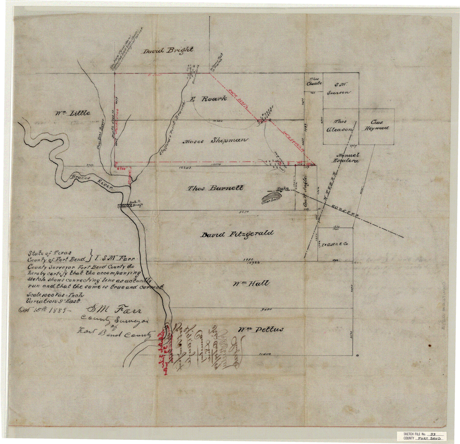
Fort Bend County Sketch File 33
Connecting Line
-
Map/Doc
11513
-
Collection
General Map Collection
-
Object Dates
1889/10/15 (Creation Date)
1889/10/19 (File Date)
-
People and Organizations
S.M. Farr (Surveyor/Engineer)
-
Counties
Fort Bend
-
Subjects
Surveying Sketch File
-
Height x Width
23.6 x 24.5 inches
59.9 x 62.2 cm
-
Medium
paper, manuscript
-
Scale
1" = 1000 varas
-
Features
Steep Bank Bayou
Brazos River
Stafford's Point Branch of Brazos River
Clear Lake
Duke
H&TB
GC&SF
Santa Fe Bridge
Part of: General Map Collection
Harris County Rolled Sketch 88

Print $20.00
- Digital $50.00
Harris County Rolled Sketch 88
1937
Size 34.9 x 22.7 inches
Map/Doc 6126
Outer Continental Shelf Leasing Maps (Louisiana Offshore Operations)

Print $20.00
- Digital $50.00
Outer Continental Shelf Leasing Maps (Louisiana Offshore Operations)
1955
Size 11.2 x 7.4 inches
Map/Doc 76087
Webb County Rolled Sketch 57

Print $20.00
- Digital $50.00
Webb County Rolled Sketch 57
Size 23.5 x 32.2 inches
Map/Doc 8209
Maps of Gulf Intracoastal Waterway, Texas - Sabine River to the Rio Grande and connecting waterways including ship channels

Print $20.00
- Digital $50.00
Maps of Gulf Intracoastal Waterway, Texas - Sabine River to the Rio Grande and connecting waterways including ship channels
1966
Size 14.6 x 22.4 inches
Map/Doc 61924

Jeff Davis County Rolled Sketch 24

Print $20.00
- Digital $50.00
Jeff Davis County Rolled Sketch 24
1953
Size 23.2 x 32.5 inches
Map/Doc 6372
Morris County Rolled Sketch 2A

Print $20.00
- Digital $50.00
Morris County Rolled Sketch 2A
Size 24.0 x 18.8 inches
Map/Doc 10257

Crosby County Sketch File 24

Print $4.00
- Digital $50.00
Crosby County Sketch File 24
Size 7.3 x 8.8 inches
Map/Doc 20091
Stephens County Sketch File 12

Print $8.00
- Digital $50.00
Stephens County Sketch File 12
1884
Size 10.8 x 8.3 inches
Map/Doc 37057
Refugio County, Texas

Print $20.00
- Digital $50.00
Refugio County, Texas
1896
Size 22.6 x 28.8 inches
Map/Doc 5024
Palo Pinto County

Print $20.00
- Digital $50.00
Palo Pinto County
1898
Size 46.3 x 39.1 inches
Map/Doc 66965
You may also like
Flight Mission No. DAH-17M, Frame 62, Orange County

Print $20.00
- Digital $50.00
Flight Mission No. DAH-17M, Frame 62, Orange County
1953
Size 18.5 x 22.6 inches
Map/Doc 86896
General Highway Map, Jim Hogg County, Texas

Print $20.00
General Highway Map, Jim Hogg County, Texas
1940
Size 24.8 x 18.5 inches
Map/Doc 79146
Nueces County Sketch File 49

Print $20.00
- Digital $50.00
Nueces County Sketch File 49
1956
Size 32.4 x 17.1 inches
Map/Doc 42193
Highway Map State of Texas

Print $20.00
Highway Map State of Texas
1919
Size 31.9 x 33.1 inches
Map/Doc 76291
Roberts County Working Sketch 13

Print $20.00
- Digital $50.00
Roberts County Working Sketch 13
1971
Size 20.2 x 16.0 inches
Map/Doc 63539
Culberson County Sketch File 32

Print $22.00
- Digital $50.00
Culberson County Sketch File 32
1952
Size 11.2 x 8.7 inches
Map/Doc 20285
A Map of Mexico, Louisiana and the Missouri Territory, including also the State of Mississippi, Alabama Territory, East & West Florida, Georgia, South Carolina & part of the Island of Cuba

Print $40.00
A Map of Mexico, Louisiana and the Missouri Territory, including also the State of Mississippi, Alabama Territory, East & West Florida, Georgia, South Carolina & part of the Island of Cuba
Size 66.9 x 64.2 inches
Map/Doc 95312
Grayson County Working Sketch 6

Print $20.00
- Digital $50.00
Grayson County Working Sketch 6
1940
Size 28.6 x 40.5 inches
Map/Doc 63245
General Highway Map, Jim Wells County, Texas

Print $20.00
General Highway Map, Jim Wells County, Texas
1961
Size 18.1 x 24.7 inches
Map/Doc 79542
Calhoun County Rolled Sketch 30

Print $20.00
- Digital $50.00
Calhoun County Rolled Sketch 30
1974
Size 18.6 x 27.2 inches
Map/Doc 5497
Hardeman County Sketch File 3

Print $8.00
- Digital $50.00
Hardeman County Sketch File 3
1880
Size 14.2 x 8.8 inches
Map/Doc 24987
Jim Hogg County Rolled Sketch EJF

Print $20.00
- Digital $50.00
Jim Hogg County Rolled Sketch EJF
1937
Size 36.0 x 32.4 inches
Map/Doc 9320