El Paso County Boundary File 8
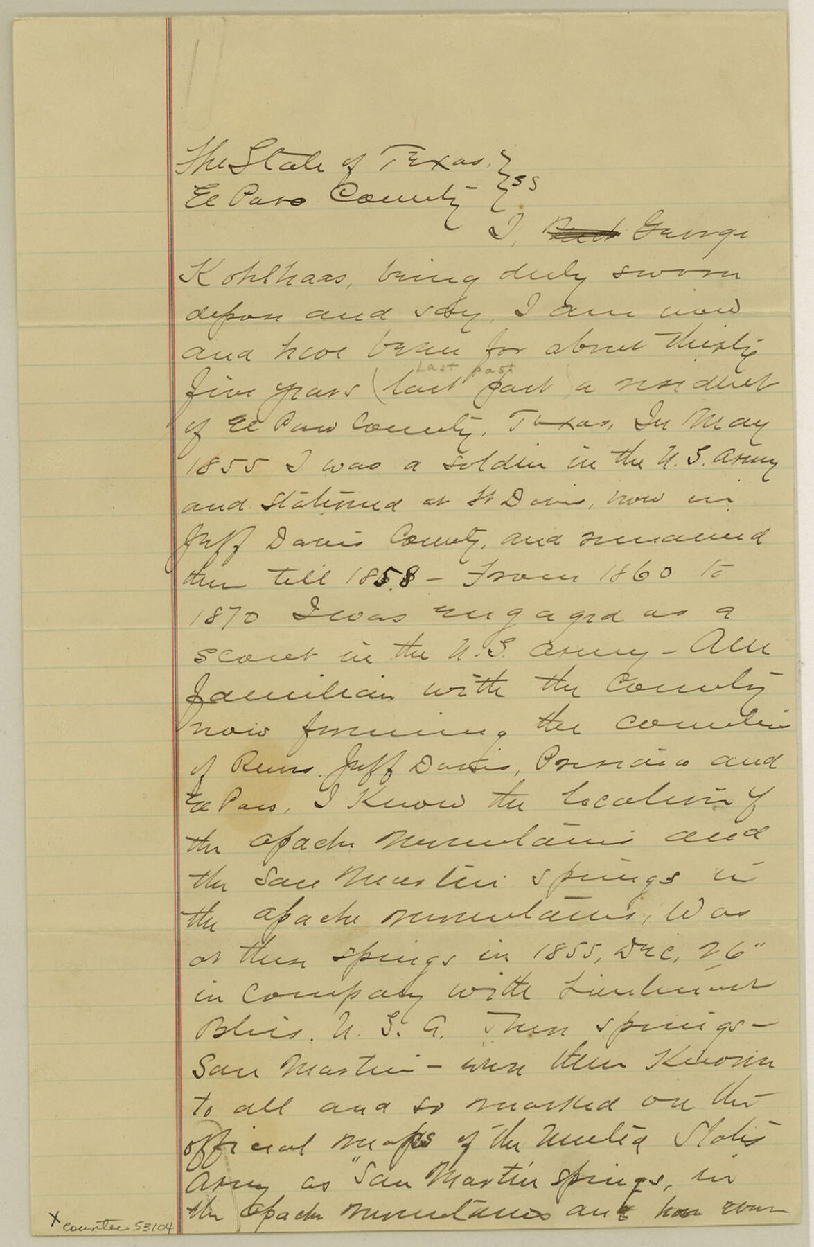
Affidavit of Kohlhass statement of two Springs of same name (Martin) & thirty-five miles apart
-
Map/Doc
53104
-
Collection
General Map Collection
-
Counties
El Paso
-
Subjects
County Boundaries
-
Height x Width
12.8 x 8.3 inches
32.5 x 21.1 cm
Part of: General Map Collection
Donley County Sketch File 1a

Print $20.00
- Digital $50.00
Donley County Sketch File 1a
Size 23.6 x 16.6 inches
Map/Doc 11362
Cochran County Sketch File A

Print $20.00
- Digital $50.00
Cochran County Sketch File A
1923
Size 21.2 x 12.5 inches
Map/Doc 11102
Nacogdoches County Boundary File 1a

Print $20.00
- Digital $50.00
Nacogdoches County Boundary File 1a
Size 4.7 x 30.5 inches
Map/Doc 57581
Key to Photo Index Sheets of Texas Coast Portion

Print $20.00
- Digital $50.00
Key to Photo Index Sheets of Texas Coast Portion
1954
Size 20.0 x 24.0 inches
Map/Doc 83437
Brazos River, Brazos River Sheet 3

Print $20.00
- Digital $50.00
Brazos River, Brazos River Sheet 3
1926
Size 27.4 x 39.7 inches
Map/Doc 69667
Wichita County Sketch File 30

Print $32.00
- Digital $50.00
Wichita County Sketch File 30
1930
Size 8.8 x 8.3 inches
Map/Doc 40136
Flight Mission No. DQN-3K, Frame 71, Calhoun County

Print $20.00
- Digital $50.00
Flight Mission No. DQN-3K, Frame 71, Calhoun County
1953
Size 18.7 x 22.3 inches
Map/Doc 84362
McCulloch County

Print $20.00
- Digital $50.00
McCulloch County
1949
Size 41.0 x 31.1 inches
Map/Doc 77361
Harris County Sketch File 73

Print $6.00
- Digital $50.00
Harris County Sketch File 73
1942
Size 11.3 x 8.9 inches
Map/Doc 25539
Irion County Rolled Sketch 18A

Print $20.00
- Digital $50.00
Irion County Rolled Sketch 18A
Size 45.5 x 29.8 inches
Map/Doc 6327
Red River County Working Sketch 34

Print $20.00
- Digital $50.00
Red River County Working Sketch 34
1963
Size 25.8 x 33.1 inches
Map/Doc 72017
Hutchinson County Rolled Sketch 43

Print $40.00
- Digital $50.00
Hutchinson County Rolled Sketch 43
1992
Size 40.4 x 49.4 inches
Map/Doc 6313
You may also like

Bird's Eye View of the City of Waco

Print $20.00
Bird's Eye View of the City of Waco
1873
Size 19.6 x 24.0 inches
Map/Doc 89211
Corpus Christi Pass, Texas

Print $20.00
- Digital $50.00
Corpus Christi Pass, Texas
1871
Size 26.2 x 18.3 inches
Map/Doc 72979
Liberty County Sketch File 14

Print $4.00
- Digital $50.00
Liberty County Sketch File 14
1858
Size 12.9 x 8.1 inches
Map/Doc 29915
Parker County Sketch File 34

Print $20.00
- Digital $50.00
Parker County Sketch File 34
1878
Size 21.3 x 13.6 inches
Map/Doc 12148
Terry County Working Sketch 2

Print $20.00
- Digital $50.00
Terry County Working Sketch 2
1952
Size 19.3 x 19.3 inches
Map/Doc 62107
Coast Chart No. 106 - Oyster Bay to Matagorda Bay, Texas

Print $20.00
- Digital $50.00
Coast Chart No. 106 - Oyster Bay to Matagorda Bay, Texas
1878
Size 24.7 x 30.0 inches
Map/Doc 69928
Flight Mission No. DQO-8K, Frame 42, Galveston County

Print $20.00
- Digital $50.00
Flight Mission No. DQO-8K, Frame 42, Galveston County
1952
Size 18.5 x 22.3 inches
Map/Doc 85149
Newton County Rolled Sketch 18

Print $40.00
- Digital $50.00
Newton County Rolled Sketch 18
1955
Size 41.6 x 59.2 inches
Map/Doc 9580
Crockett County Rolled Sketch 21

Print $20.00
- Digital $50.00
Crockett County Rolled Sketch 21
Size 33.0 x 24.4 inches
Map/Doc 5582
Ward County Sketch File 10

Print $6.00
- Digital $50.00
Ward County Sketch File 10
1936
Size 11.2 x 8.9 inches
Map/Doc 39635
Hansford County Sketch File 2

Print $13.00
- Digital $50.00
Hansford County Sketch File 2
1901
Size 76.7 x 25.5 inches
Map/Doc 10476