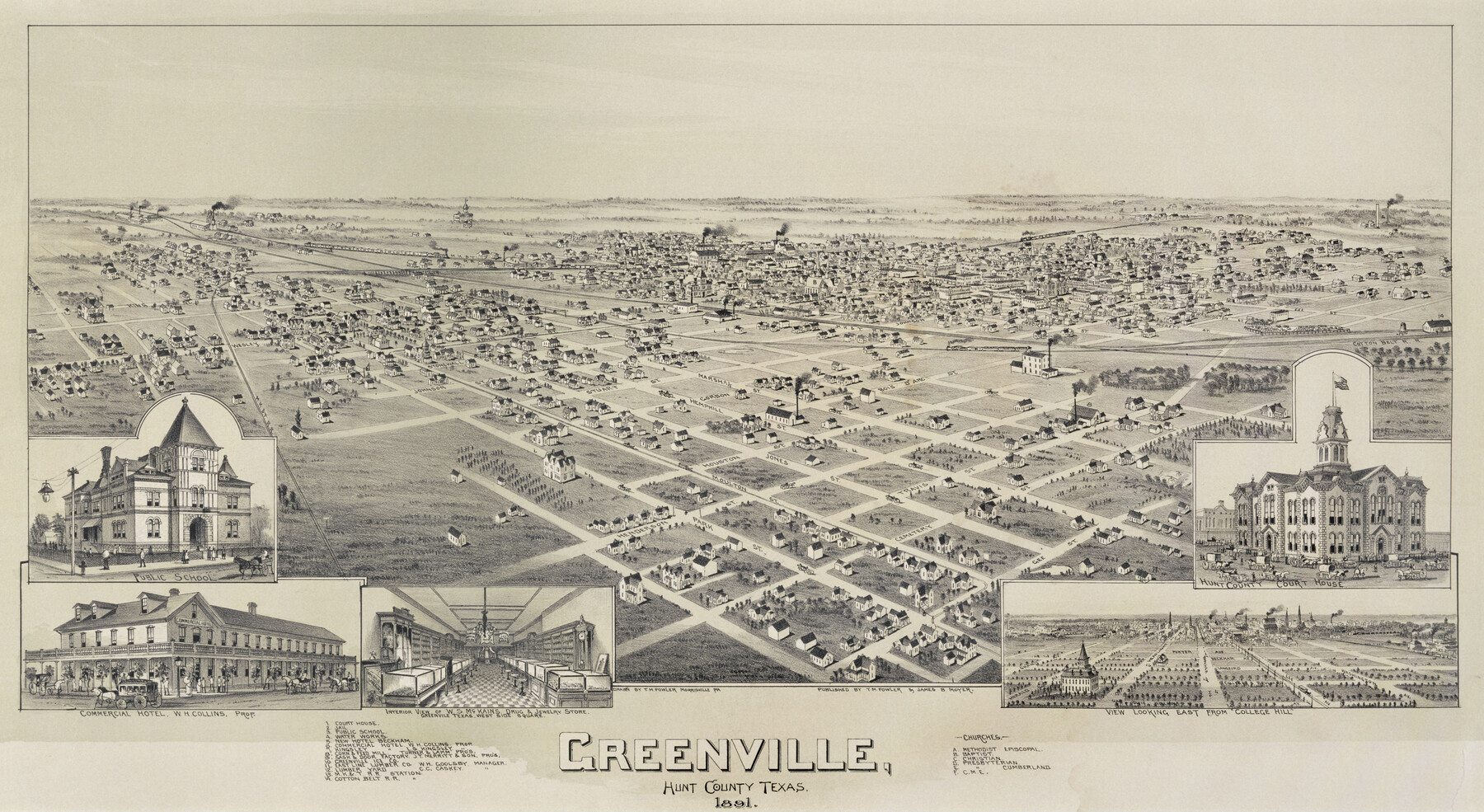
Greenville, Hunt County Texas
-
Map/Doc
89090
-
Collection
Non-GLO Digital Images
-
Object Dates
1891 (Creation Date)
-
People and Organizations
T. M. Fowler, James B. Moyer (Publisher)
Thaddeus Mortimer Fowler (Draftsman)
-
Counties
Hunt
-
Subjects
Bird's Eye View City Pictorial
-
Height x Width
16.4 x 30.0 inches
41.7 x 76.2 cm
-
Comments
Bird's Eye View map. Public Domain image obtained from Wikimedia Commons.
Part of: Non-GLO Digital Images
Plano de la Villa y Presidio de S. Antonio de Vejar situado en la Provincia de Tejas en 29 grad. y 52 minutos de latitud bor. y 275° y 57' de long. contados desde de Meridiano d. Tenerife

Plano de la Villa y Presidio de S. Antonio de Vejar situado en la Provincia de Tejas en 29 grad. y 52 minutos de latitud bor. y 275° y 57' de long. contados desde de Meridiano d. Tenerife
1768
Size 16.8 x 21.2 inches
Map/Doc 96564
County Map of Texas, and Indian Territory

Print $20.00
County Map of Texas, and Indian Territory
1872
Size 18.9 x 16.1 inches
Map/Doc 88820
Paris, Texas, County Seat of Lamar County

Print $20.00
Paris, Texas, County Seat of Lamar County
1885
Size 17.8 x 23.8 inches
Map/Doc 89201
City of Round Rock, Texas

Print $20.00
City of Round Rock, Texas
1958
Size 25.3 x 31.5 inches
Map/Doc 87359
Carta geográfica que comprende en su extensión mucha parte del arzobispado de México, y alguna de los obispados de Puebla, Valladolid de Michoacán, Guadalajara y Durango, confinantes entre si

Carta geográfica que comprende en su extensión mucha parte del arzobispado de México, y alguna de los obispados de Puebla, Valladolid de Michoacán, Guadalajara y Durango, confinantes entre si
1779
Size 33.9 x 22.0 inches
Map/Doc 97079
Map of Colorado City on the west bank of the Colorado River at the La Bahia crossing

Print $20.00
Map of Colorado City on the west bank of the Colorado River at the La Bahia crossing
1841
Size 24.4 x 32.5 inches
Map/Doc 94750
[Movements & Objectives of the 143rd & 144th Infantry on October 12-13, 1918] - Verso
![94136, [Movements & Objectives of the 143rd & 144th Infantry on October 12-13, 1918] - Verso, Non-GLO Digital Images](https://historictexasmaps.com/wmedia_w700/maps/94136-1.tif.jpg)
Print $20.00
[Movements & Objectives of the 143rd & 144th Infantry on October 12-13, 1918] - Verso
1918
Size 42.4 x 30.0 inches
Map/Doc 94136
The Official Map of the City of El Paso, State of Texas

Print $20.00
The Official Map of the City of El Paso, State of Texas
1889
Size 41.9 x 46.2 inches
Map/Doc 89618
Amérique Septentrionale

Print $20.00
Amérique Septentrionale
1845
Size 13.8 x 20.3 inches
Map/Doc 94571
[Movements & Objectives of the 143rd & 144th Infantry on October 9-11, 1918, Appendix E, Nos.2 and 3]
![94131, [Movements & Objectives of the 143rd & 144th Infantry on October 9-11, 1918, Appendix E, Nos.2 and 3], Non-GLO Digital Images](https://historictexasmaps.com/wmedia_w700/maps/94131-1.tif.jpg)
Print $20.00
[Movements & Objectives of the 143rd & 144th Infantry on October 9-11, 1918, Appendix E, Nos.2 and 3]
1918
Size 41.6 x 19.9 inches
Map/Doc 94131

Plan of New Orleans

Print $20.00
- Digital $50.00
Plan of New Orleans
1860
Size 12.8 x 15.7 inches
Map/Doc 95910
You may also like
[Map of Matagorda County]
![3841, [Map of Matagorda County], General Map Collection](https://historictexasmaps.com/wmedia_w700/maps/3841-1.tif.jpg)
Print $20.00
- Digital $50.00
[Map of Matagorda County]
Size 24.4 x 25.6 inches
Map/Doc 3841
Knox County Working Sketch 12

Print $20.00
- Digital $50.00
Knox County Working Sketch 12
1951
Size 26.2 x 23.5 inches
Map/Doc 70254
Coryell County Working Sketch 18

Print $20.00
- Digital $50.00
Coryell County Working Sketch 18
1965
Size 24.6 x 34.3 inches
Map/Doc 68225
Reeves County Working Sketch 33

Print $20.00
- Digital $50.00
Reeves County Working Sketch 33
1970
Size 39.9 x 45.7 inches
Map/Doc 63476

Garza County Rolled Sketch R-2

Print $40.00
- Digital $50.00
Garza County Rolled Sketch R-2
Size 36.0 x 50.2 inches
Map/Doc 9046
Frio County Working Sketch 15

Print $20.00
- Digital $50.00
Frio County Working Sketch 15
1961
Size 31.2 x 43.5 inches
Map/Doc 69289
Galveston County Rolled Sketch DB

Print $20.00
- Digital $50.00
Galveston County Rolled Sketch DB
Size 37.0 x 47.5 inches
Map/Doc 9854
[Area north of Leagues 1 & 4, Morris County School Land]
![90353, [Area north of Leagues 1 & 4, Morris County School Land], Twichell Survey Records](https://historictexasmaps.com/wmedia_w700/maps/90353-1.tif.jpg)
Print $20.00
- Digital $50.00
[Area north of Leagues 1 & 4, Morris County School Land]
Size 21.3 x 16.0 inches
Map/Doc 90353
Lamar County Sketch File 12

Print $20.00
- Digital $50.00
Lamar County Sketch File 12
Size 19.5 x 23.3 inches
Map/Doc 11967
Concho County Working Sketch 18
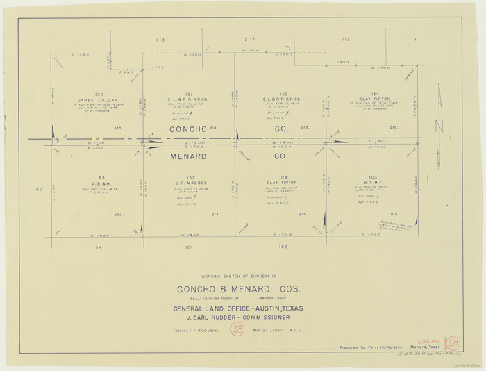
Print $20.00
- Digital $50.00
Concho County Working Sketch 18
1957
Size 19.2 x 25.2 inches
Map/Doc 68200
San Patricio County Sketch File 17

Print $20.00
San Patricio County Sketch File 17
1873
Size 12.0 x 19.0 inches
Map/Doc 12284