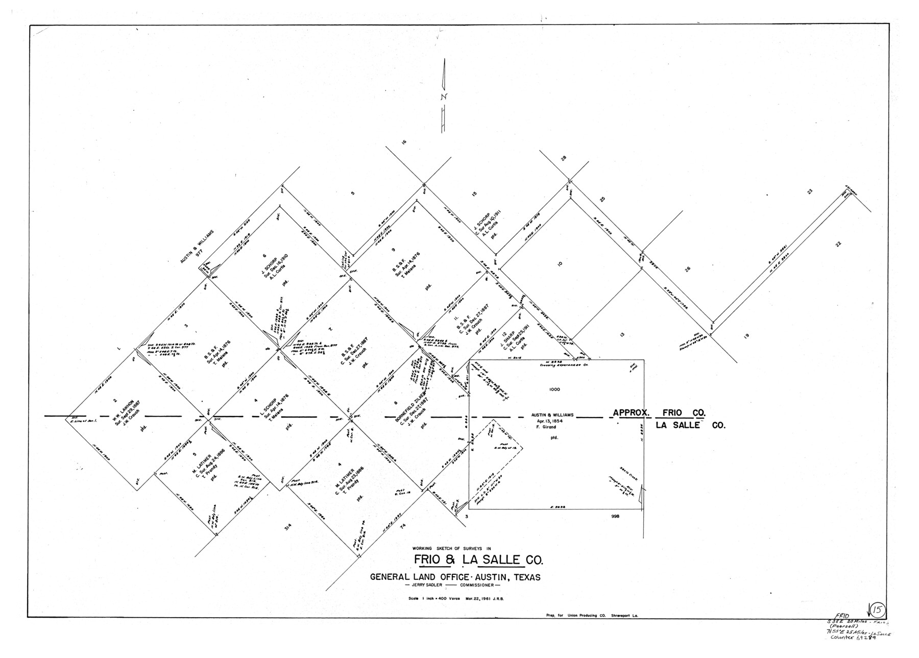
Frio County Working Sketch 15
-
Map/Doc
69289
-
Collection
General Map Collection
-
Object Dates
3/22/1961 (Creation Date)
-
Counties
Frio La Salle
-
Subjects
Surveying Working Sketch
-
Height x Width
31.2 x 43.5 inches
79.3 x 110.5 cm
-
Scale
1" = 400 varas
Part of: General Map Collection
Loving County Sketch File 4

Print $40.00
- Digital $50.00
Loving County Sketch File 4
1961
Size 20.6 x 24.7 inches
Map/Doc 12014
Dallas/Fort Worth Street Map & Visitor Guide

Dallas/Fort Worth Street Map & Visitor Guide
2000
Size 35.6 x 23.2 inches
Map/Doc 94295
Map of the United States and Mexico showing the Trans-Union and Tehuantepec route between Europe and Asia

Print $20.00
- Digital $50.00
Map of the United States and Mexico showing the Trans-Union and Tehuantepec route between Europe and Asia
1851
Size 20.3 x 23.7 inches
Map/Doc 94851
Bailey County

Print $20.00
- Digital $50.00
Bailey County
1956
Size 47.0 x 30.0 inches
Map/Doc 77206
Travis County Sketch File 16

Print $4.00
- Digital $50.00
Travis County Sketch File 16
Size 12.7 x 8.4 inches
Map/Doc 38312
Brazoria County Rolled Sketch 49

Print $20.00
- Digital $50.00
Brazoria County Rolled Sketch 49
1948
Size 23.8 x 36.2 inches
Map/Doc 5184
Webb County Rolled Sketch 46

Print $20.00
- Digital $50.00
Webb County Rolled Sketch 46
1942
Size 25.8 x 27.6 inches
Map/Doc 8202
Flight Mission No. DAG-24K, Frame 53, Matagorda County

Print $20.00
- Digital $50.00
Flight Mission No. DAG-24K, Frame 53, Matagorda County
1953
Size 18.5 x 22.3 inches
Map/Doc 86540
Pecos County Sketch File 48

Print $4.00
- Digital $50.00
Pecos County Sketch File 48
1935
Size 14.3 x 8.8 inches
Map/Doc 33762
Atascosa County

Print $20.00
- Digital $50.00
Atascosa County
1948
Size 47.6 x 44.9 inches
Map/Doc 77204
Layout of the porciones as described in the Visita General of Mier, 1767

Layout of the porciones as described in the Visita General of Mier, 1767
2009
Size 11.0 x 8.5 inches
Map/Doc 94043
Webb County Working Sketch 44

Print $20.00
- Digital $50.00
Webb County Working Sketch 44
1943
Size 26.0 x 27.4 inches
Map/Doc 72409
You may also like
Working Sketch in Archer County

Print $20.00
- Digital $50.00
Working Sketch in Archer County
1924
Size 30.8 x 42.3 inches
Map/Doc 90175
Jefferson County Sketch File 52

Print $2.00
- Digital $50.00
Jefferson County Sketch File 52
1985
Size 9.1 x 14.4 inches
Map/Doc 28254

Lee County Sketch File 10

Print $10.00
- Digital $50.00
Lee County Sketch File 10
2009
Size 11.0 x 8.5 inches
Map/Doc 89289
[Map of Matagorda County Showing Abandoned Surveys]
![2066, [Map of Matagorda County Showing Abandoned Surveys], General Map Collection](https://historictexasmaps.com/wmedia_w700/maps/2066.tif.jpg)
Print $40.00
- Digital $50.00
[Map of Matagorda County Showing Abandoned Surveys]
1920
Size 50.3 x 40.2 inches
Map/Doc 2066
Hopkins County Sketch File 2a

Print $4.00
- Digital $50.00
Hopkins County Sketch File 2a
Size 13.6 x 8.6 inches
Map/Doc 26683
Flight Mission No. CUG-2P, Frame 83, Kleberg County

Print $20.00
- Digital $50.00
Flight Mission No. CUG-2P, Frame 83, Kleberg County
1956
Size 18.5 x 22.3 inches
Map/Doc 86215
Map of part of Waller County

Print $20.00
- Digital $50.00
Map of part of Waller County
Size 16.3 x 13.5 inches
Map/Doc 685
Brown County Sketch File 16

Print $6.00
- Digital $50.00
Brown County Sketch File 16
1872
Size 10.8 x 10.1 inches
Map/Doc 16612
Armstrong County Rolled Sketch OS

Print $20.00
- Digital $50.00
Armstrong County Rolled Sketch OS
1902
Size 17.5 x 32.4 inches
Map/Doc 5086
Corpus Christi Bay

Print $20.00
- Digital $50.00
Corpus Christi Bay
1971
Size 36.4 x 47.4 inches
Map/Doc 73472
Kinney County Sketch File B

Print $8.00
- Digital $50.00
Kinney County Sketch File B
1873
Size 11.9 x 8.1 inches
Map/Doc 29119